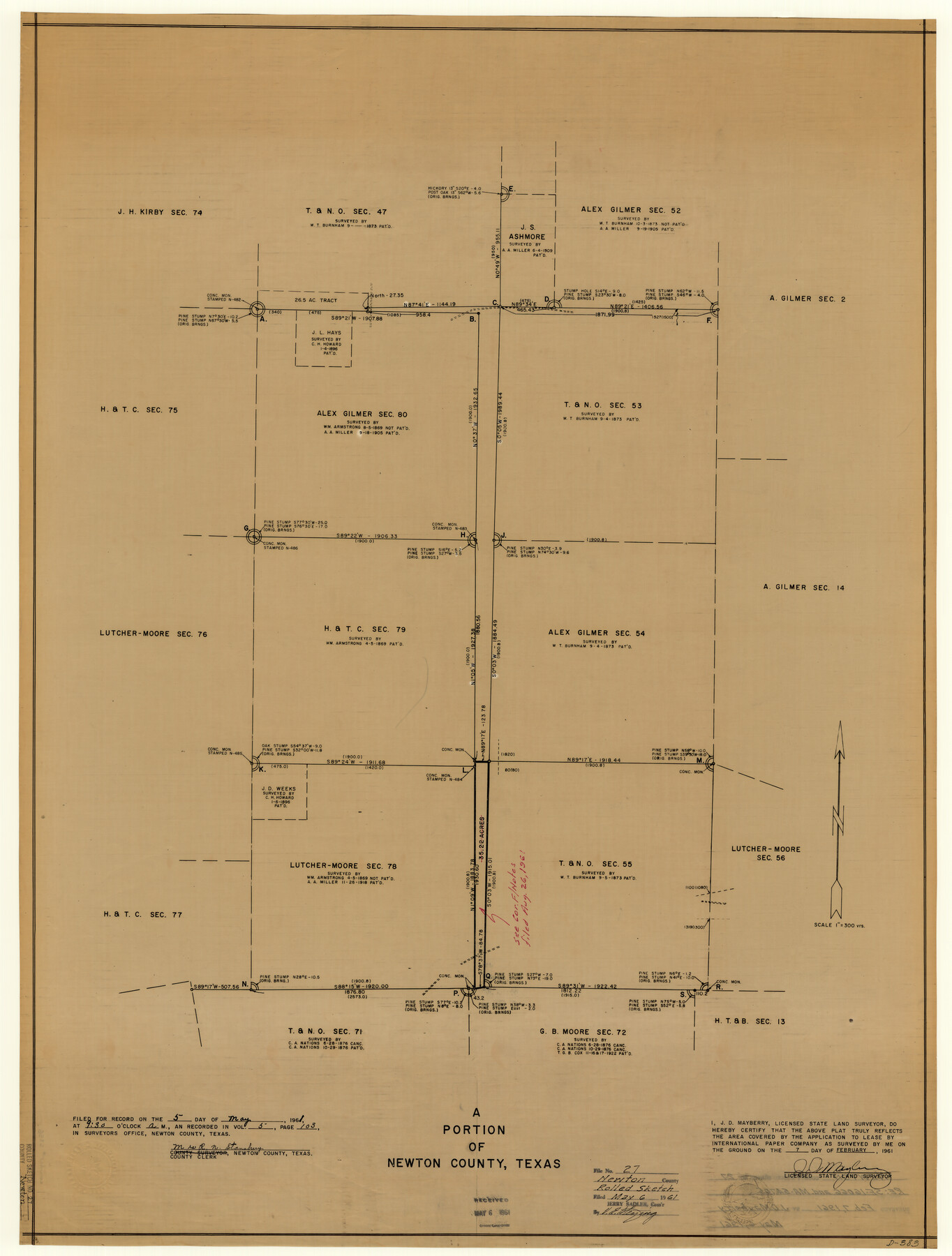
Newton County Rolled Sketch 27
A portion of Newton County, Texas
-
Map/Doc
6856
-
Collection
General Map Collection
-
Object Dates
1961/2/7 (Creation Date)
1961/5/6 (File Date)
-
People and Organizations
J.D. Mayberry (Surveyor/Engineer)
-
Counties
Newton
-
Subjects
Surveying Rolled Sketch
-
Height x Width
36.0 x 27.3 inches
91.4 x 69.3 cm
-
Medium
blueprint/diazo
-
Scale
1" = 300 varas
Part of: General Map Collection
Starr County Working Sketch 20

Print $20.00
- Digital $50.00
Starr County Working Sketch 20
1982
Size 29.5 x 35.2 inches
Map/Doc 63936
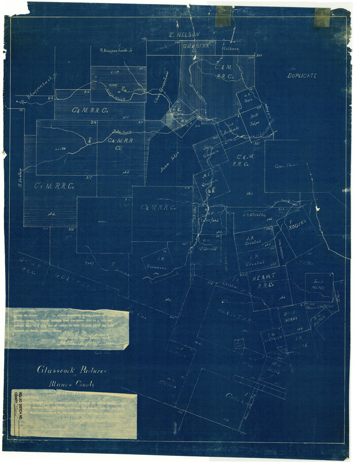
Blanco County Rolled Sketch 7
Print $20.00
- Digital $50.00
Blanco County Rolled Sketch 7
Size 31.0 x 23.8 inches
Map/Doc 5144
Titus County Sketch File 3

Print $40.00
- Digital $50.00
Titus County Sketch File 3
1852
Size 19.9 x 8.4 inches
Map/Doc 38134
Crockett County Rolled Sketch 31

Print $40.00
- Digital $50.00
Crockett County Rolled Sketch 31
Size 58.1 x 50.0 inches
Map/Doc 8716
Fractional Township No. 11 South Range No. 27 East of the Indian Meridian, Indian Territory

Print $20.00
- Digital $50.00
Fractional Township No. 11 South Range No. 27 East of the Indian Meridian, Indian Territory
1897
Size 19.2 x 24.3 inches
Map/Doc 75247
San Patricio County Rolled Sketch BB

Print $40.00
- Digital $50.00
San Patricio County Rolled Sketch BB
1936
Size 25.0 x 49.0 inches
Map/Doc 9889
Johnson County Working Sketch 7

Print $20.00
- Digital $50.00
Johnson County Working Sketch 7
1951
Size 23.0 x 21.3 inches
Map/Doc 66620
Flight Mission No. CRE-1R, Frame 125, Jackson County

Print $20.00
- Digital $50.00
Flight Mission No. CRE-1R, Frame 125, Jackson County
1956
Size 17.5 x 22.3 inches
Map/Doc 85336
Nueces County NRC Article 33.136 Sketch 1

Print $274.00
- Digital $50.00
Nueces County NRC Article 33.136 Sketch 1
2002
Size 24.5 x 36.3 inches
Map/Doc 87920
Webb County Rolled Sketch 35

Print $20.00
- Digital $50.00
Webb County Rolled Sketch 35
1939
Size 23.1 x 12.7 inches
Map/Doc 8190
Flight Mission No. DQN-7K, Frame 37, Calhoun County

Print $20.00
- Digital $50.00
Flight Mission No. DQN-7K, Frame 37, Calhoun County
1953
Size 18.4 x 22.1 inches
Map/Doc 84475
Menard County Working Sketch 30

Print $20.00
- Digital $50.00
Menard County Working Sketch 30
1974
Size 47.9 x 38.8 inches
Map/Doc 70977
You may also like
Sutton County Working Sketch 23

Print $20.00
- Digital $50.00
Sutton County Working Sketch 23
1981
Size 17.3 x 27.1 inches
Map/Doc 62366
Liberty County Rolled Sketch JP

Print $40.00
- Digital $50.00
Liberty County Rolled Sketch JP
Size 43.6 x 70.1 inches
Map/Doc 9566
General Highway Map, Walker County, Texas

Print $20.00
General Highway Map, Walker County, Texas
1940
Size 24.9 x 18.4 inches
Map/Doc 79269
Flight Mission No. DAH-9M, Frame 84, Orange County

Print $20.00
- Digital $50.00
Flight Mission No. DAH-9M, Frame 84, Orange County
1953
Size 18.7 x 22.5 inches
Map/Doc 86848
Potter County Boundary File 4b

Print $20.00
- Digital $50.00
Potter County Boundary File 4b
Size 9.2 x 32.9 inches
Map/Doc 58012
Gregg County Rolled Sketch 17

Print $20.00
- Digital $50.00
Gregg County Rolled Sketch 17
1933
Size 14.2 x 27.5 inches
Map/Doc 6041
Coleman County Sketch File 28

Print $6.00
- Digital $50.00
Coleman County Sketch File 28
1873
Size 10.2 x 15.8 inches
Map/Doc 18716
Frio County Rolled Sketch 12

Print $20.00
- Digital $50.00
Frio County Rolled Sketch 12
1948
Size 36.5 x 45.5 inches
Map/Doc 8904
Val Verde County Working Sketch 23

Print $20.00
- Digital $50.00
Val Verde County Working Sketch 23
1932
Size 29.6 x 24.9 inches
Map/Doc 72158
Stephens County Working Sketch 20

Print $20.00
- Digital $50.00
Stephens County Working Sketch 20
1972
Size 26.7 x 30.6 inches
Map/Doc 63963
Flight Mission No. BRE-1P, Frame 124, Nueces County

Print $20.00
- Digital $50.00
Flight Mission No. BRE-1P, Frame 124, Nueces County
1956
Size 18.6 x 22.7 inches
Map/Doc 86690
'The Cradle of Texas' - San Augustine

Print $20.00
- Digital $50.00
'The Cradle of Texas' - San Augustine
Size 19.3 x 25.3 inches
Map/Doc 94441