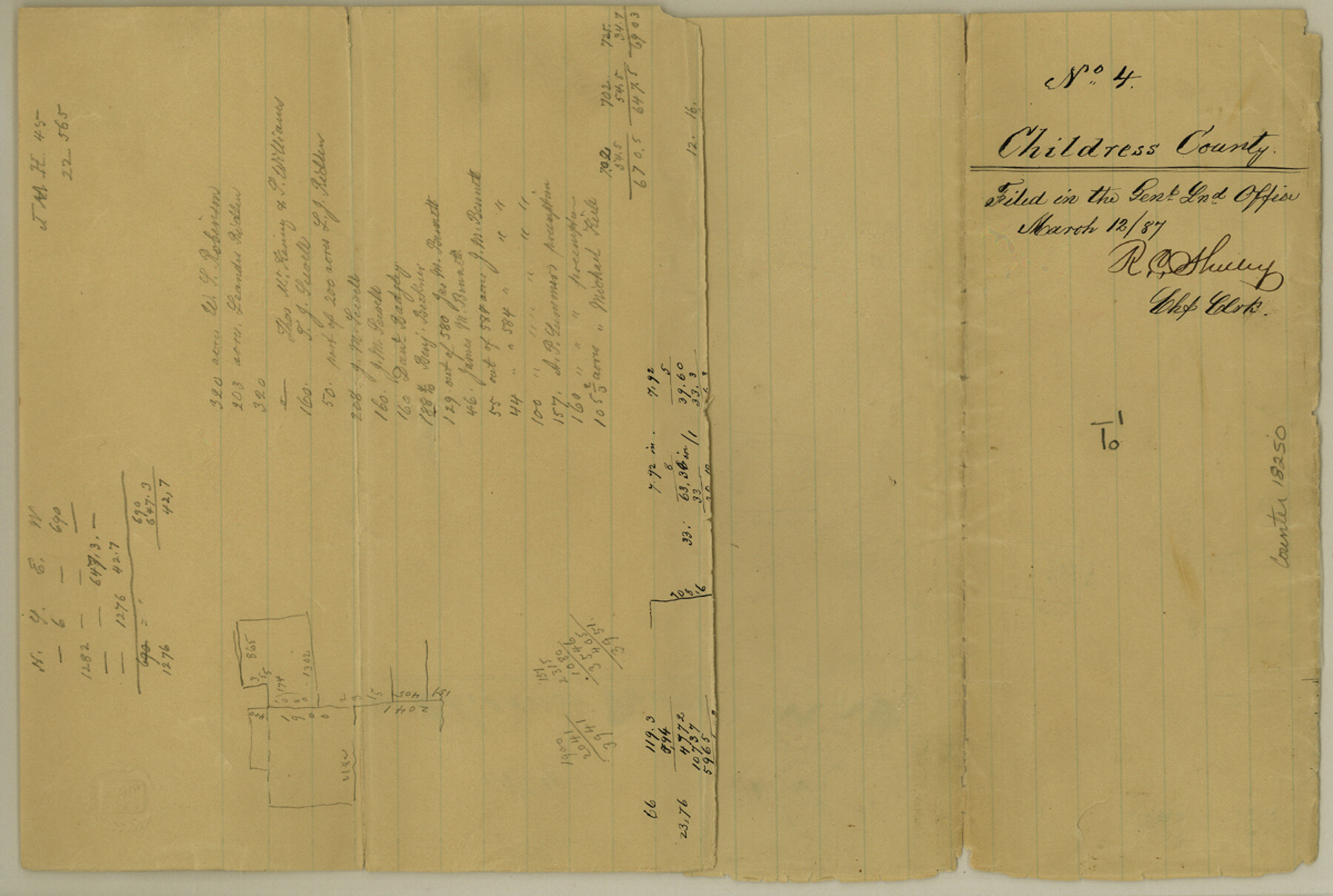
Childress County Sketch File 4
Sketch of Childress County showing location of homestead & pre-emption surveys [north of the Prairie Dog Town Fork of Red River]
-
Map/Doc
18250
-
Collection
General Map Collection
-
Object Dates
1887/3/7 (Creation Date)
1887/3/12 (File Date)
-
People and Organizations
T.S. McClelland (Surveyor/Engineer)
-
Counties
Childress
-
Subjects
Surveying Sketch File
-
Height x Width
8.1 x 12.0 inches
20.6 x 30.5 cm
-
Medium
paper, manuscript
-
Features
Red River
Part of: General Map Collection
Coke County Rolled Sketch 13

Print $40.00
- Digital $50.00
Coke County Rolled Sketch 13
Size 44.5 x 69.9 inches
Map/Doc 8627
Sutton County Sketch File 5

Print $40.00
- Digital $50.00
Sutton County Sketch File 5
Size 14.0 x 17.3 inches
Map/Doc 37356
Hill County Boundary File 45c

Print $64.00
- Digital $50.00
Hill County Boundary File 45c
Size 14.5 x 8.8 inches
Map/Doc 54784
Pecos County Rolled Sketch 134

Print $20.00
- Digital $50.00
Pecos County Rolled Sketch 134
1952
Size 35.9 x 27.0 inches
Map/Doc 7270
Flight Mission No. BRE-1P, Frame 96, Nueces County

Print $20.00
- Digital $50.00
Flight Mission No. BRE-1P, Frame 96, Nueces County
1956
Size 18.5 x 22.2 inches
Map/Doc 86667
Flight Mission No. CGI-3N, Frame 107, Cameron County

Print $20.00
- Digital $50.00
Flight Mission No. CGI-3N, Frame 107, Cameron County
1954
Size 18.6 x 22.3 inches
Map/Doc 84587
Pecos County Sketch File 36

Print $20.00
- Digital $50.00
Pecos County Sketch File 36
Size 24.9 x 35.3 inches
Map/Doc 12176
Floyd County Sketch File 13

Print $36.00
- Digital $50.00
Floyd County Sketch File 13
1913
Size 11.4 x 9.0 inches
Map/Doc 22713
Comanche County Working Sketch 6

Print $20.00
- Digital $50.00
Comanche County Working Sketch 6
1935
Size 26.4 x 17.8 inches
Map/Doc 68140
Dimmit County Sketch File 25

Print $4.00
- Digital $50.00
Dimmit County Sketch File 25
1885
Size 12.9 x 8.6 inches
Map/Doc 21142
Flight Mission No. DIX-10P, Frame 175, Aransas County

Print $20.00
- Digital $50.00
Flight Mission No. DIX-10P, Frame 175, Aransas County
1956
Size 18.6 x 22.2 inches
Map/Doc 83965
Bowie County Working Sketch 21

Print $20.00
- Digital $50.00
Bowie County Working Sketch 21
1968
Size 35.9 x 36.3 inches
Map/Doc 67425
You may also like
Treaty to Resolve Pending Boundary Differences and Maintain the Rio Grande and Colorado River as the International Boundary Between the United States of American and Mexico

Print $4.00
- Digital $50.00
Treaty to Resolve Pending Boundary Differences and Maintain the Rio Grande and Colorado River as the International Boundary Between the United States of American and Mexico
1970
Size 10.9 x 18.1 inches
Map/Doc 83101
Falls County Boundary File 3

Print $15.00
- Digital $50.00
Falls County Boundary File 3
Size 8.6 x 3.8 inches
Map/Doc 53266
Gillespie County Sketch File 2

Print $40.00
- Digital $50.00
Gillespie County Sketch File 2
1847
Size 12.8 x 15.5 inches
Map/Doc 24127
Jasper County Sketch File 1a

Print $8.00
- Digital $50.00
Jasper County Sketch File 1a
1859
Size 12.1 x 7.7 inches
Map/Doc 27765
Guadalupe County Sketch File 7b

Print $4.00
- Digital $50.00
Guadalupe County Sketch File 7b
Size 7.3 x 10.9 inches
Map/Doc 24670
Concho County Sketch File 17

Print $20.00
- Digital $50.00
Concho County Sketch File 17
1896
Size 10.2 x 20.9 inches
Map/Doc 11152
Austin County Boundary File 5

Print $6.00
- Digital $50.00
Austin County Boundary File 5
Size 14.3 x 8.5 inches
Map/Doc 50249
Anderson County Working Sketch 9

Print $20.00
- Digital $50.00
Anderson County Working Sketch 9
1929
Size 30.7 x 22.1 inches
Map/Doc 67008
Brewster County Working Sketch Graphic Index, North Part, Sheet 2 (Sketches 87 to Most Recent)

Print $20.00
- Digital $50.00
Brewster County Working Sketch Graphic Index, North Part, Sheet 2 (Sketches 87 to Most Recent)
1956
Size 41.8 x 39.5 inches
Map/Doc 76474
Clay County Sketch File 29

Print $16.00
- Digital $50.00
Clay County Sketch File 29
Size 11.3 x 8.7 inches
Map/Doc 18448
[Map of Hunt County]
![3691, [Map of Hunt County], General Map Collection](https://historictexasmaps.com/wmedia_w700/maps/3691-1.tif.jpg)
Print $20.00
- Digital $50.00
[Map of Hunt County]
1851
Size 21.6 x 19.1 inches
Map/Doc 3691
Flight Mission No. CUG-3P, Frame 171, Kleberg County

Print $20.00
- Digital $50.00
Flight Mission No. CUG-3P, Frame 171, Kleberg County
1956
Size 18.4 x 22.3 inches
Map/Doc 86291