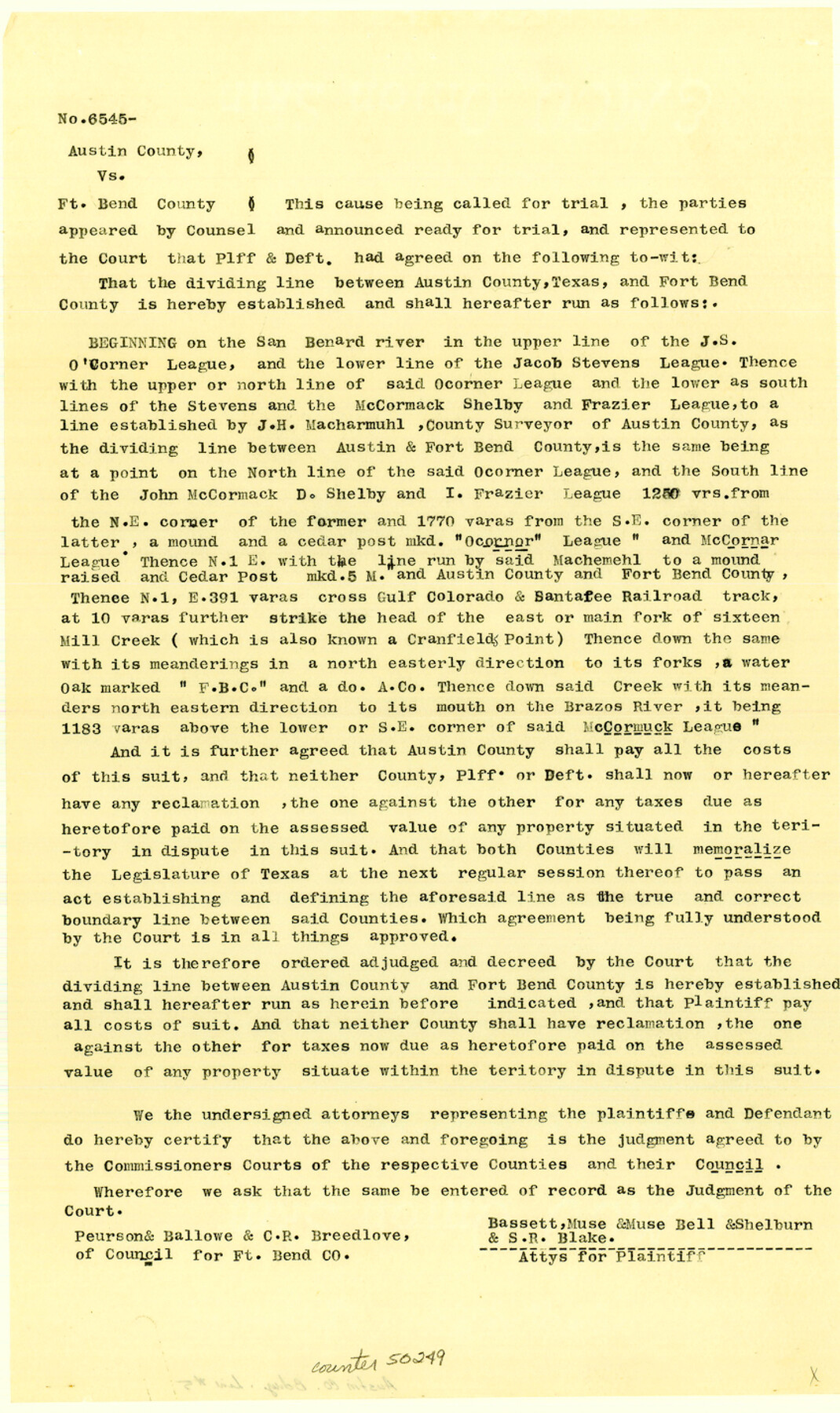
Austin County Boundary File 5
Austin County vs. Fort Bend County Certified copy of Agreed Judgment, No. 6545
-
Map/Doc
50249
-
Collection
General Map Collection
-
Counties
Austin
-
Subjects
County Boundaries
-
Height x Width
14.3 x 8.5 inches
36.3 x 21.6 cm
Part of: General Map Collection
Sabine County Boundary File 1

Print $96.00
- Digital $50.00
Sabine County Boundary File 1
Size 14.4 x 8.8 inches
Map/Doc 58530
Flight Mission No. BRA-7M, Frame 87, Jefferson County

Print $20.00
- Digital $50.00
Flight Mission No. BRA-7M, Frame 87, Jefferson County
1953
Size 18.5 x 22.3 inches
Map/Doc 85509
Presidio County Sketch File 57

Print $8.00
- Digital $50.00
Presidio County Sketch File 57
1938
Size 14.3 x 8.9 inches
Map/Doc 34624
McLennan County Sketch File 17

Print $4.00
- Digital $50.00
McLennan County Sketch File 17
1876
Size 7.9 x 12.7 inches
Map/Doc 31278
Hale County Working Sketch 7

Print $20.00
- Digital $50.00
Hale County Working Sketch 7
1963
Size 24.4 x 20.6 inches
Map/Doc 63327
Castro County Sketch File 10

Print $6.00
- Digital $50.00
Castro County Sketch File 10
1916
Size 8.2 x 5.4 inches
Map/Doc 17501

Flight Mission No. CRC-2R, Frame 199, Chambers County

Print $20.00
- Digital $50.00
Flight Mission No. CRC-2R, Frame 199, Chambers County
1956
Size 18.6 x 22.4 inches
Map/Doc 84777
Terry County Sketch File 4

Print $20.00
- Digital $50.00
Terry County Sketch File 4
1913
Size 14.4 x 8.7 inches
Map/Doc 38016
Winkler County

Print $20.00
- Digital $50.00
Winkler County
1932
Size 39.4 x 39.5 inches
Map/Doc 63132
Chart of the Harbour of San [Luis]
![72762, Chart of the Harbour of San [Luis], General Map Collection](https://historictexasmaps.com/wmedia_w700/maps/72762.tif.jpg)
Print $20.00
- Digital $50.00
Chart of the Harbour of San [Luis]
1846
Size 27.2 x 18.2 inches
Map/Doc 72762
Bee County Working Sketch 30

Print $20.00
- Digital $50.00
Bee County Working Sketch 30
1950
Size 12.7 x 15.7 inches
Map/Doc 67281
You may also like
General Highway Map, Borden County, Texas

Print $20.00
General Highway Map, Borden County, Texas
1961
Size 18.3 x 25.0 inches
Map/Doc 79377
Andrews County Sketch File 3

Print $46.00
- Digital $50.00
Andrews County Sketch File 3
1928
Size 33.0 x 36.6 inches
Map/Doc 10317
Crockett County Rolled Sketch 23

Print $20.00
- Digital $50.00
Crockett County Rolled Sketch 23
1924
Size 34.2 x 26.6 inches
Map/Doc 5583
Howard County Rolled Sketch 7

Print $20.00
- Digital $50.00
Howard County Rolled Sketch 7
Size 12.0 x 16.7 inches
Map/Doc 6236
Williamson County Working Sketch 9

Print $20.00
- Digital $50.00
Williamson County Working Sketch 9
1954
Size 31.2 x 30.0 inches
Map/Doc 72569

Dallas County

Print $20.00
- Digital $50.00
Dallas County
1942
Size 45.1 x 37.1 inches
Map/Doc 77258
Flight Mission No. BQR-14K, Frame 40, Brazoria County

Print $20.00
- Digital $50.00
Flight Mission No. BQR-14K, Frame 40, Brazoria County
1952
Size 18.7 x 22.3 inches
Map/Doc 84097
Runnels County Sketch File 29

Print $20.00
Runnels County Sketch File 29
1950
Size 23.8 x 18.0 inches
Map/Doc 12261

Uvalde County Working Sketch 51

Print $20.00
- Digital $50.00
Uvalde County Working Sketch 51
1981
Size 34.7 x 37.7 inches
Map/Doc 72121
Matagorda County Rolled Sketch 18A

Print $20.00
- Digital $50.00
Matagorda County Rolled Sketch 18A
1838
Size 35.4 x 30.1 inches
Map/Doc 6686