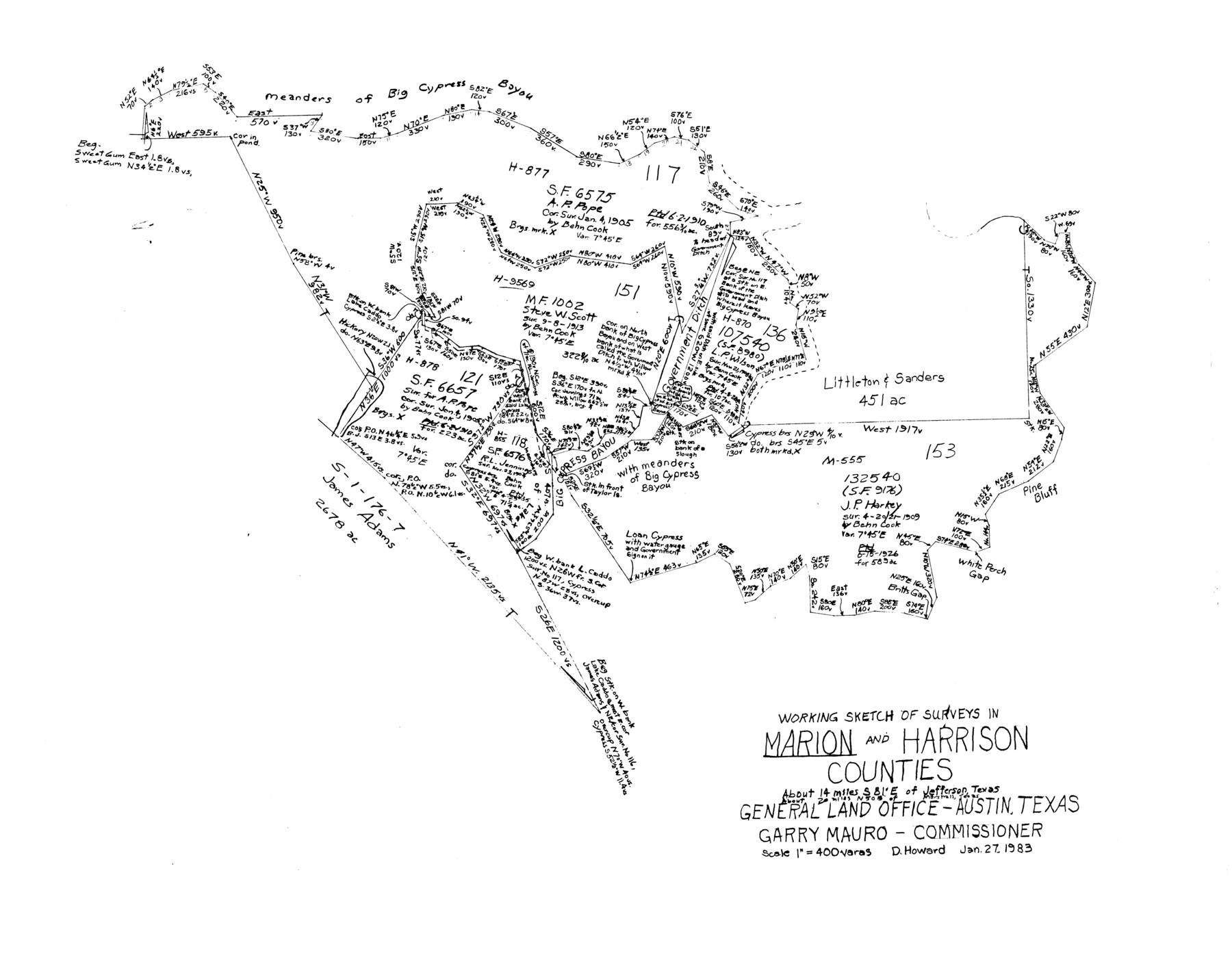
Marion County Working Sketch 33
-
Map/Doc
70809
-
Collection
General Map Collection
-
Object Dates
1/27/1983 (Creation Date)
-
People and Organizations
Douglas Howard (Draftsman)
-
Counties
Marion Harrison
-
Subjects
Surveying Working Sketch
-
Height x Width
16.0 x 20.7 inches
40.6 x 52.6 cm
-
Scale
1" = 400 varas
Part of: General Map Collection
Matagorda County Rolled Sketch 13

Print $20.00
- Digital $50.00
Matagorda County Rolled Sketch 13
1917
Size 11.3 x 37.1 inches
Map/Doc 7590
Brazos River, Brazos River Sheet 5

Print $20.00
- Digital $50.00
Brazos River, Brazos River Sheet 5
1926
Size 27.4 x 21.7 inches
Map/Doc 69669
Upshur County Sketch File 18

Print $39.00
- Digital $50.00
Upshur County Sketch File 18
Size 11.4 x 8.9 inches
Map/Doc 38773
Aransas County NRC Article 33.136 Sketch 14

Print $36.00
- Digital $50.00
Aransas County NRC Article 33.136 Sketch 14
2016
Size 18.0 x 24.0 inches
Map/Doc 94795
Flight Mission No. CLL-1N, Frame 82, Willacy County

Print $20.00
- Digital $50.00
Flight Mission No. CLL-1N, Frame 82, Willacy County
1954
Size 18.3 x 22.1 inches
Map/Doc 87028
Nacogdoches County Sketch File 2

Print $4.00
- Digital $50.00
Nacogdoches County Sketch File 2
1852
Size 8.0 x 6.4 inches
Map/Doc 32235
Andrews County Rolled Sketch 42

Print $20.00
- Digital $50.00
Andrews County Rolled Sketch 42
Size 27.3 x 36.0 inches
Map/Doc 77182
Eastland County Rolled Sketch 25

Print $20.00
- Digital $50.00
Eastland County Rolled Sketch 25
1990
Size 36.9 x 47.7 inches
Map/Doc 8831
Maps of Gulf Intracoastal Waterway, Texas - Sabine River to the Rio Grande and connecting waterways including ship channels

Print $20.00
- Digital $50.00
Maps of Gulf Intracoastal Waterway, Texas - Sabine River to the Rio Grande and connecting waterways including ship channels
1966
Size 14.6 x 22.3 inches
Map/Doc 61950
Flight Mission No. CRC-5R, Frame 31, Chambers County

Print $20.00
- Digital $50.00
Flight Mission No. CRC-5R, Frame 31, Chambers County
1956
Size 18.5 x 22.4 inches
Map/Doc 84950
Bosque County Sketch File 19

Print $4.00
- Digital $50.00
Bosque County Sketch File 19
1863
Size 12.9 x 6.2 inches
Map/Doc 14794
[Maps of surveys in Reeves & Culberson Cos]
![61146, [Maps of surveys in Reeves & Culberson Cos], General Map Collection](https://historictexasmaps.com/wmedia_w700/maps/61146.tif.jpg)
Print $20.00
- Digital $50.00
[Maps of surveys in Reeves & Culberson Cos]
1937
Size 30.8 x 24.9 inches
Map/Doc 61146
You may also like
Duval County Rolled Sketch 37

Print $20.00
- Digital $50.00
Duval County Rolled Sketch 37
Size 19.8 x 16.5 inches
Map/Doc 5754
Texas Aerial Photo-Illustrated Map

Texas Aerial Photo-Illustrated Map
Size 21.3 x 28.3 inches
Map/Doc 94398
Platte (sic) of the unorganized County School Lands in the District of Young

Print $20.00
- Digital $50.00
Platte (sic) of the unorganized County School Lands in the District of Young
Size 16.0 x 12.3 inches
Map/Doc 90453
Knox County Boundary File 1

Print $24.00
- Digital $50.00
Knox County Boundary File 1
Size 14.2 x 8.6 inches
Map/Doc 64998
Flight Mission No. BQR-3K, Frame 159, Brazoria County

Print $20.00
- Digital $50.00
Flight Mission No. BQR-3K, Frame 159, Brazoria County
1952
Size 18.6 x 22.3 inches
Map/Doc 83986
Sherman County Boundary File 2

Print $34.00
- Digital $50.00
Sherman County Boundary File 2
Size 13.0 x 9.0 inches
Map/Doc 58761
Callahan County Sketch File 10

Print $40.00
- Digital $50.00
Callahan County Sketch File 10
Size 21.7 x 24.7 inches
Map/Doc 11039
San Augustine County Sketch File 13

Print $4.00
San Augustine County Sketch File 13
1875
Size 11.4 x 7.6 inches
Map/Doc 35658
Zavala County Sketch File 44

Print $25.00
- Digital $50.00
Zavala County Sketch File 44
1915
Size 10.1 x 14.3 inches
Map/Doc 41416
Denton County Sketch File 19

Print $10.00
- Digital $50.00
Denton County Sketch File 19
Size 10.0 x 7.3 inches
Map/Doc 20733
Waco, Tex., County Seat of McLennan Co.

Print $20.00
Waco, Tex., County Seat of McLennan Co.
1886
Size 23.1 x 32.7 inches
Map/Doc 89212
Duval County Rolled Sketch WSR

Print $20.00
- Digital $50.00
Duval County Rolled Sketch WSR
1938
Size 39.2 x 26.8 inches
Map/Doc 5772