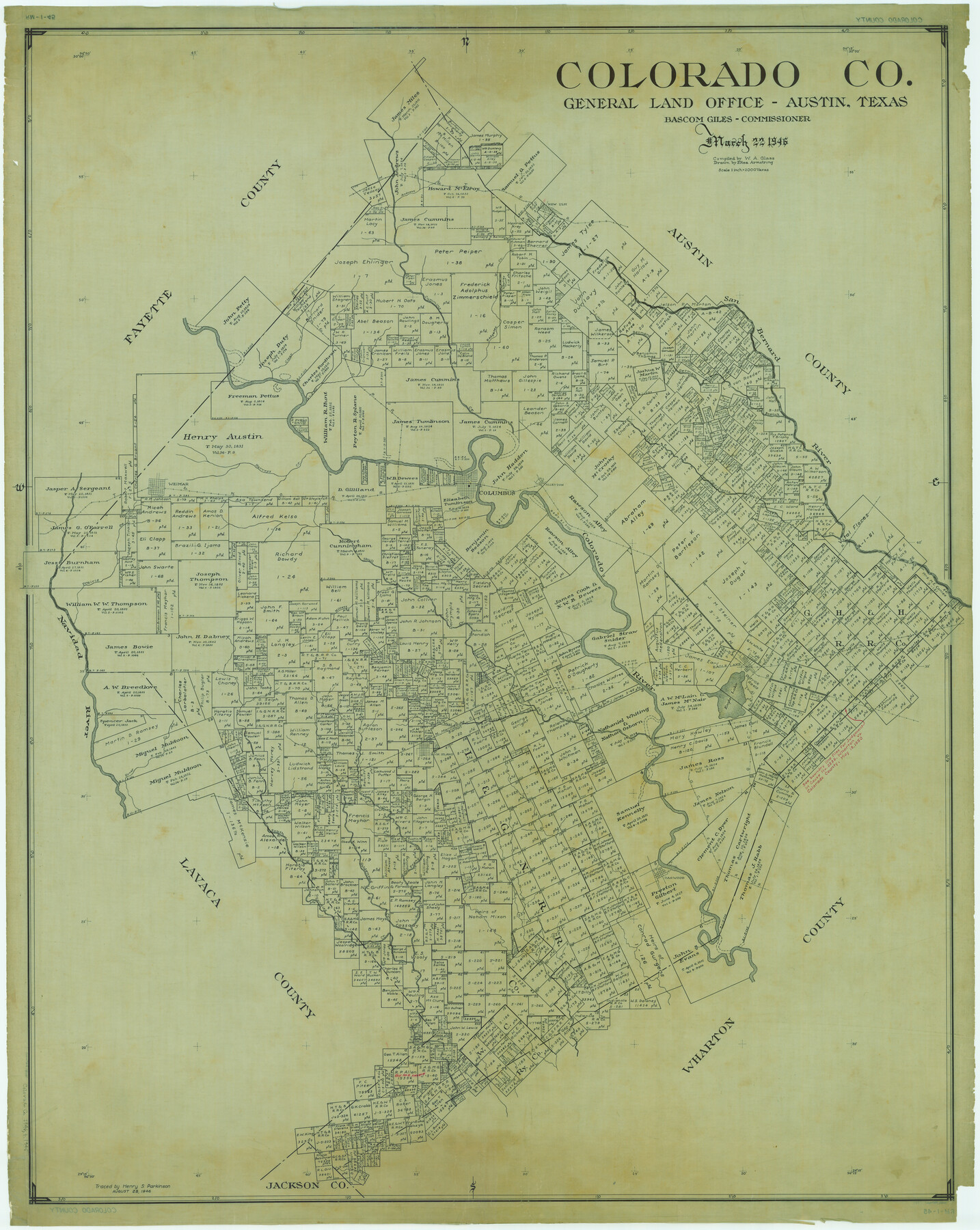
Colorado Co.
RM-1-45
-
Map/Doc
1805
-
Collection
General Map Collection
-
Object Dates
1946/3/22 (Creation Date)
-
People and Organizations
Texas General Land Office (Publisher)
Eltea Armstrong (Draftsman)
Bascom Giles (GLO Commissioner)
W.A. Glass (Compiler)
-
Counties
Colorado
-
Subjects
County
-
Height x Width
53.7 x 42.8 inches
136.4 x 108.7 cm
-
Comments
Traced August 28, 1946 by Henry S. Parkinson.
Part of: General Map Collection
Val Verde County Sketch File Z4

Print $8.00
- Digital $50.00
Val Verde County Sketch File Z4
1885
Size 14.3 x 8.9 inches
Map/Doc 39134
Flight Mission No. BQY-4M, Frame 122, Harris County

Print $20.00
- Digital $50.00
Flight Mission No. BQY-4M, Frame 122, Harris County
1953
Size 18.6 x 22.4 inches
Map/Doc 85290
Flight Mission No. BQR-4K, Frame 58, Brazoria County

Print $20.00
- Digital $50.00
Flight Mission No. BQR-4K, Frame 58, Brazoria County
1952
Size 18.7 x 22.4 inches
Map/Doc 83991
Galveston County NRC Article 33.136 Sketch 26

Print $45.00
- Digital $50.00
Galveston County NRC Article 33.136 Sketch 26
2003
Size 32.6 x 24.3 inches
Map/Doc 81943
Presidio County Working Sketch 86

Print $20.00
- Digital $50.00
Presidio County Working Sketch 86
1971
Size 45.4 x 42.2 inches
Map/Doc 71763
[Sketch & Field Note Calls of Pecos, Terrell & Val Verde Counties, Texas]
![1720, [Sketch & Field Note Calls of Pecos, Terrell & Val Verde Counties, Texas], General Map Collection](https://historictexasmaps.com/wmedia_w700/pdf_converted_jpg/qi_pdf_thumbnail_734.jpg)
Print $20.00
- Digital $50.00
[Sketch & Field Note Calls of Pecos, Terrell & Val Verde Counties, Texas]
1915
Size 19.4 x 24.2 inches
Map/Doc 1720
Floyd County Sketch File 32

Print $8.00
- Digital $50.00
Floyd County Sketch File 32
1952
Size 14.3 x 8.9 inches
Map/Doc 22792
Liberty County Working Sketch 91b

Print $40.00
- Digital $50.00
Liberty County Working Sketch 91b
1919
Size 48.7 x 42.1 inches
Map/Doc 65458
Pecos County Sketch File 48

Print $4.00
- Digital $50.00
Pecos County Sketch File 48
1935
Size 14.3 x 8.8 inches
Map/Doc 33762
Hays County Sketch File 32

Print $8.00
- Digital $50.00
Hays County Sketch File 32
Size 14.3 x 8.8 inches
Map/Doc 26264
Flight Mission No. DQO-8K, Frame 87, Galveston County

Print $20.00
- Digital $50.00
Flight Mission No. DQO-8K, Frame 87, Galveston County
1952
Size 18.6 x 22.4 inches
Map/Doc 85189
Old Miscellaneous File 27

Print $28.00
- Digital $50.00
Old Miscellaneous File 27
1879
Size 14.4 x 8.8 inches
Map/Doc 75636
You may also like
Coleman County

Print $40.00
- Digital $50.00
Coleman County
1945
Size 55.7 x 37.1 inches
Map/Doc 95458
Kerr County Rolled Sketch 4

Print $20.00
- Digital $50.00
Kerr County Rolled Sketch 4
Size 21.8 x 23.1 inches
Map/Doc 6493
Culberson County Sketch File 7

Print $8.00
- Digital $50.00
Culberson County Sketch File 7
1888
Size 14.5 x 8.8 inches
Map/Doc 20138
Harris County Working Sketch 128

Print $20.00
- Digital $50.00
Harris County Working Sketch 128
1996
Size 15.0 x 14.0 inches
Map/Doc 66020
Map No. 3 by W. D. Twichell

Print $20.00
- Digital $50.00
Map No. 3 by W. D. Twichell
Size 42.5 x 32.9 inches
Map/Doc 89710
Kendall County Boundary File 54

Print $16.00
- Digital $50.00
Kendall County Boundary File 54
Size 8.6 x 3.5 inches
Map/Doc 55769
EL&RR S2, HE&WT K3, Pt.L&SV K, C4 & C3

Print $20.00
- Digital $50.00
EL&RR S2, HE&WT K3, Pt.L&SV K, C4 & C3
Size 23.3 x 17.5 inches
Map/Doc 90416
Bee County Sketch File 11

Print $40.00
- Digital $50.00
Bee County Sketch File 11
Size 20.8 x 25.0 inches
Map/Doc 10915
Flight Mission No. BRE-1P, Frame 147, Nueces County

Print $20.00
- Digital $50.00
Flight Mission No. BRE-1P, Frame 147, Nueces County
1956
Size 18.5 x 22.3 inches
Map/Doc 86707
J. N. Watson Subdivision of Blocks 1, 6, 7, and 43, Lamesa, Texas

Print $20.00
- Digital $50.00
J. N. Watson Subdivision of Blocks 1, 6, 7, and 43, Lamesa, Texas
Size 11.6 x 24.8 inches
Map/Doc 92574
Flight Mission No. DAG-16K, Frame 69, Matagorda County

Print $20.00
- Digital $50.00
Flight Mission No. DAG-16K, Frame 69, Matagorda County
1952
Size 18.4 x 22.2 inches
Map/Doc 86315
Map of Perico, Dallam County, Texas

Print $20.00
- Digital $50.00
Map of Perico, Dallam County, Texas
Size 20.1 x 16.7 inches
Map/Doc 92128