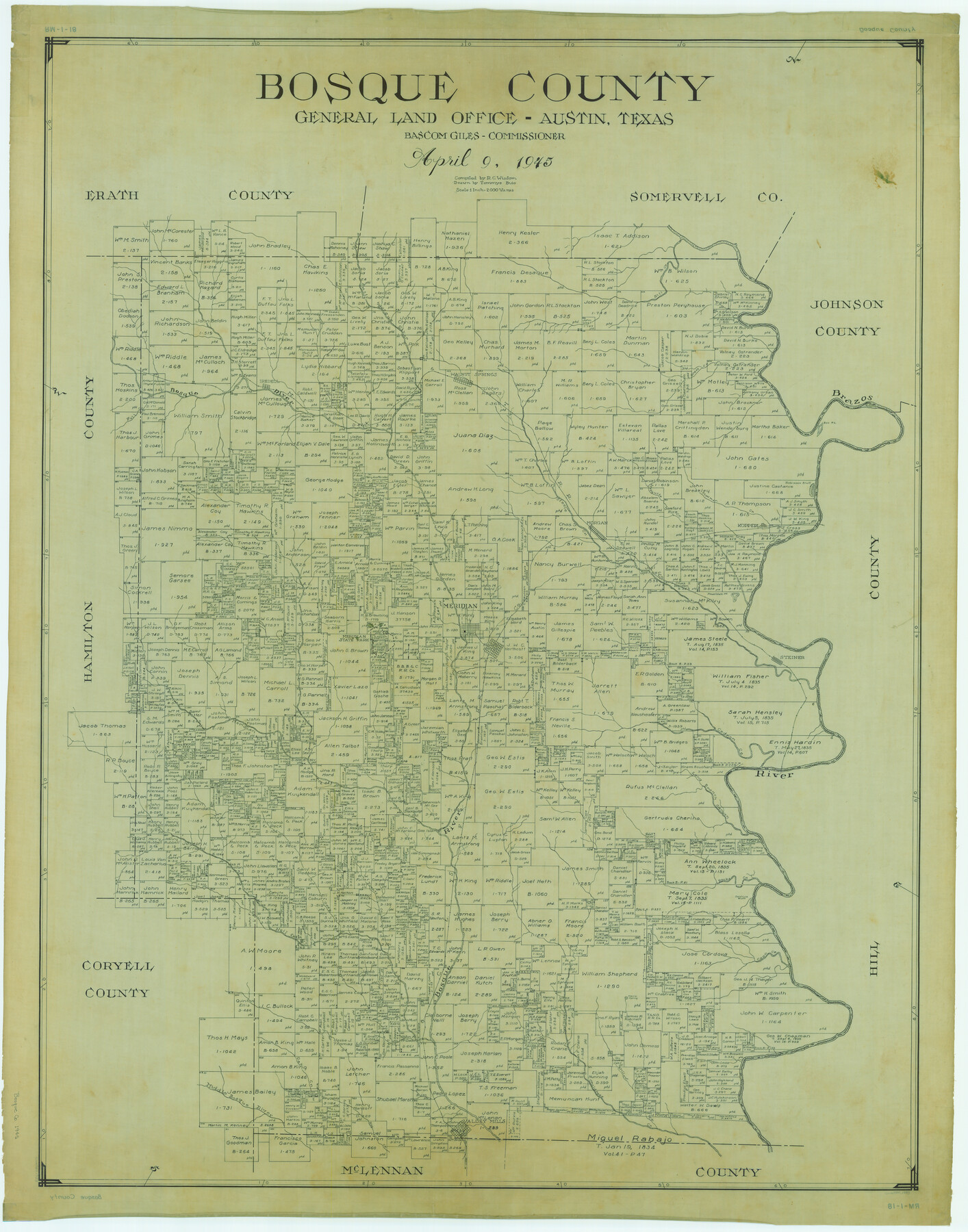
Bosque County
RM-1-18
-
Map/Doc
1783
-
Collection
General Map Collection
-
Object Dates
1945/4/9 (Creation Date)
-
People and Organizations
Texas General Land Office (Publisher)
Bascom Giles (GLO Commissioner)
Tommye Buie (Draftsman)
R.C. Wisdom (Compiler)
-
Counties
Bosque
-
Subjects
County
-
Height x Width
49.0 x 38.5 inches
124.5 x 97.8 cm
Part of: General Map Collection
Plat showing survey of tracts in the C. A. West survey A-337 and the Wm. Standiferd survey A-301 in Bastrop County as surveyed for the Veteran's Land Board

Print $20.00
- Digital $50.00
Plat showing survey of tracts in the C. A. West survey A-337 and the Wm. Standiferd survey A-301 in Bastrop County as surveyed for the Veteran's Land Board
1992
Size 34.9 x 46.8 inches
Map/Doc 61151
Flight Mission No. BRA-6M, Frame 149, Jefferson County

Print $20.00
- Digital $50.00
Flight Mission No. BRA-6M, Frame 149, Jefferson County
1953
Size 18.5 x 22.3 inches
Map/Doc 85450
Flight Mission No. DIX-6P, Frame 119, Aransas County

Print $20.00
- Digital $50.00
Flight Mission No. DIX-6P, Frame 119, Aransas County
1956
Size 19.1 x 22.7 inches
Map/Doc 83825

Knox County Working Sketch 6

Print $20.00
- Digital $50.00
Knox County Working Sketch 6
1937
Size 31.4 x 18.2 inches
Map/Doc 70248
Morris County Rolled Sketch 2A

Print $20.00
- Digital $50.00
Morris County Rolled Sketch 2A
Size 24.0 x 18.8 inches
Map/Doc 10275
Pecos County Working Sketch 69

Print $40.00
- Digital $50.00
Pecos County Working Sketch 69
1956
Size 48.7 x 32.6 inches
Map/Doc 71541
Township No. 5 South Range No. 9 West of the Indian Meridian

Print $20.00
- Digital $50.00
Township No. 5 South Range No. 9 West of the Indian Meridian
1874
Size 19.2 x 24.4 inches
Map/Doc 75167
Uvalde County Sketch File 26-1

Print $6.00
- Digital $50.00
Uvalde County Sketch File 26-1
1930
Size 11.5 x 8.9 inches
Map/Doc 39013
Brewster County Rolled Sketch 114

Print $20.00
- Digital $50.00
Brewster County Rolled Sketch 114
1964
Size 12.0 x 18.4 inches
Map/Doc 5278
Jefferson County Rolled Sketch 41

Print $20.00
- Digital $50.00
Jefferson County Rolled Sketch 41
1897
Size 17.6 x 25.4 inches
Map/Doc 6400
Grayson County Working Sketch 15

Print $20.00
- Digital $50.00
Grayson County Working Sketch 15
1953
Size 24.8 x 20.6 inches
Map/Doc 63254
You may also like
[North 1/2 of Garza County, South 1/2 of Crosby County]
![90908, [North 1/2 of Garza County, South 1/2 of Crosby County], Twichell Survey Records](https://historictexasmaps.com/wmedia_w700/maps/90908-1.tif.jpg)
Print $20.00
- Digital $50.00
[North 1/2 of Garza County, South 1/2 of Crosby County]
Size 34.7 x 31.1 inches
Map/Doc 90908
Pecos County Working Sketch 111

Print $40.00
- Digital $50.00
Pecos County Working Sketch 111
1972
Size 32.9 x 69.6 inches
Map/Doc 71584
[T. & P. Block 35, Townships 4N and 5N]
![90629, [T. & P. Block 35, Townships 4N and 5N], Twichell Survey Records](https://historictexasmaps.com/wmedia_w700/maps/90629-1.tif.jpg)
Print $20.00
- Digital $50.00
[T. & P. Block 35, Townships 4N and 5N]
Size 26.3 x 34.7 inches
Map/Doc 90629
Kenedy County Rolled Sketch 17

Print $40.00
- Digital $50.00
Kenedy County Rolled Sketch 17
1958
Size 96.6 x 28.5 inches
Map/Doc 10726
Calhoun County Rolled Sketch 30

Print $20.00
- Digital $50.00
Calhoun County Rolled Sketch 30
1974
Size 18.6 x 27.6 inches
Map/Doc 5491
The Republic County of Washington. February 4, 1840

Print $20.00
The Republic County of Washington. February 4, 1840
2020
Size 20.3 x 21.7 inches
Map/Doc 96304
Houston - a Modern City

Print $20.00
Houston - a Modern City
1912
Size 18.2 x 23.4 inches
Map/Doc 93482
Hardin County Sketch File 30

Print $6.00
- Digital $50.00
Hardin County Sketch File 30
Size 6.5 x 8.1 inches
Map/Doc 25157

Map of section no. 4 of a survey of Padre Island made for the Office of the Attorney General of the State of Texas

Print $40.00
- Digital $50.00
Map of section no. 4 of a survey of Padre Island made for the Office of the Attorney General of the State of Texas
1941
Size 82.6 x 40.8 inches
Map/Doc 2260
Cameron County Aerial Photograph Index Sheet 6

Print $20.00
- Digital $50.00
Cameron County Aerial Photograph Index Sheet 6
1940
Size 20.3 x 24.3 inches
Map/Doc 83682
