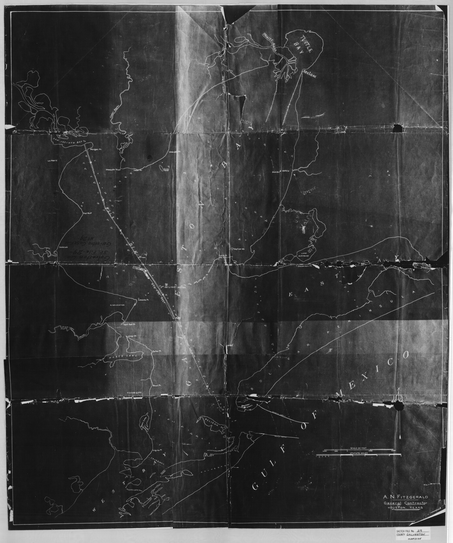
Galveston County Sketch File 29
[Maps of Galveston Bay]
-
Map/Doc
10454
-
Collection
General Map Collection
-
People and Organizations
A.N. Fitzgerald (Draftsman)
-
Counties
Galveston Chambers Harris
-
Subjects
Surveying Sketch File
-
Height x Width
35.1 x 29.3 inches
89.2 x 74.4 cm
-
Medium
multi-page, multi-format
-
Features
Bolivar Peninsula
Fishing Pier
Red Fish Reef
N. Galveston
Dickinson Bayou
Miller Point
April Fool Point
Dollar Point
Stevenson Point
Gulf of Mexico
Seabrook
Bolivar Light
North Jetty
Moses Lake
Shoal Point
Texas City
South Jetty
West Bay
Causeway
Galveston Island
Galveston Bay
Turtle Bay
Anahuac
Umbrella Point
Cedar Bayou
Swan Reef
Morgan Point
San Jacinto Bay
La Porte
Mesquite Knoll
Trinity River
Double Bayou
East Bay
Lake Surprise
Vingt'une Islands
Smith Point
Light House
Pile Dike
Red Bluff
Part of: General Map Collection
Texas-Oklahoma Clara Quadrangle

Print $20.00
- Digital $50.00
Texas-Oklahoma Clara Quadrangle
1937
Size 20.3 x 16.9 inches
Map/Doc 75105
Hardin County Working Sketch 14

Print $20.00
- Digital $50.00
Hardin County Working Sketch 14
1936
Size 25.1 x 42.6 inches
Map/Doc 63412
Henderson County

Print $40.00
- Digital $50.00
Henderson County
1922
Size 33.0 x 62.7 inches
Map/Doc 66861
Johnson County Working Sketch 15

Print $20.00
- Digital $50.00
Johnson County Working Sketch 15
1974
Size 21.6 x 23.8 inches
Map/Doc 66628
Current Miscellaneous File 65

Print $8.00
- Digital $50.00
Current Miscellaneous File 65
Size 11.2 x 8.6 inches
Map/Doc 74109
Flight Mission No. DQN-3K, Frame 50, Calhoun County

Print $20.00
- Digital $50.00
Flight Mission No. DQN-3K, Frame 50, Calhoun County
1953
Size 18.4 x 22.2 inches
Map/Doc 84351
Hays County Sketch File 15

Print $40.00
- Digital $50.00
Hays County Sketch File 15
1871
Size 12.0 x 16.6 inches
Map/Doc 26225
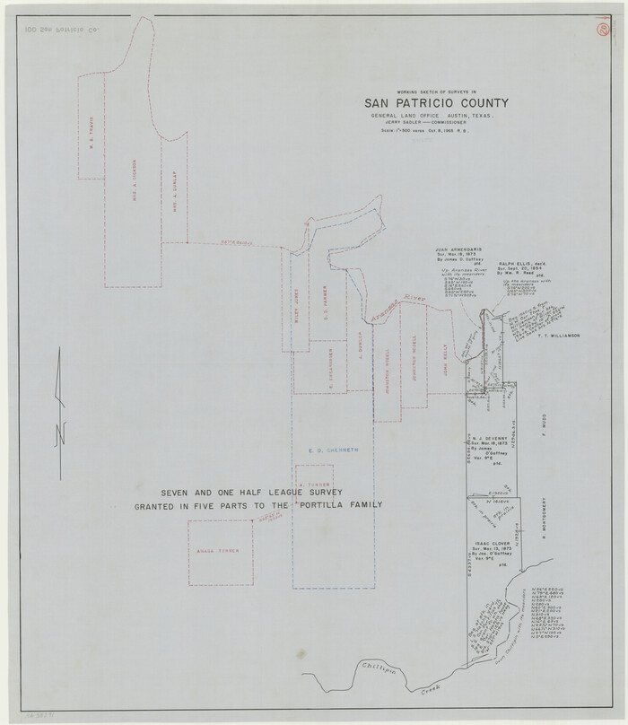
San Patricio County Working Sketch 20
Print $20.00
- Digital $50.00
San Patricio County Working Sketch 20
1965
Size 37.2 x 32.3 inches
Map/Doc 63782
Kent County Working Sketch 25

Print $20.00
- Digital $50.00
Kent County Working Sketch 25
1989
Size 18.8 x 18.5 inches
Map/Doc 69641
Rains County Working Sketch 10

Print $20.00
- Digital $50.00
Rains County Working Sketch 10
1998
Size 36.1 x 34.7 inches
Map/Doc 71836
Flight Mission No. DQO-11K, Frame 20, Galveston County

Print $20.00
- Digital $50.00
Flight Mission No. DQO-11K, Frame 20, Galveston County
1952
Size 18.8 x 22.4 inches
Map/Doc 85215
El Paso County Rolled Sketch 31

Print $20.00
- Digital $50.00
El Paso County Rolled Sketch 31
1908
Size 39.9 x 32.0 inches
Map/Doc 8858
You may also like
La Salle County Working Sketch 21

Print $20.00
- Digital $50.00
La Salle County Working Sketch 21
1942
Size 25.4 x 24.0 inches
Map/Doc 70322
Flight Mission No. BRA-7M, Frame 180, Jefferson County

Print $20.00
- Digital $50.00
Flight Mission No. BRA-7M, Frame 180, Jefferson County
1953
Size 18.7 x 22.4 inches
Map/Doc 85548
Travis County Rolled Sketch 13

Print $20.00
- Digital $50.00
Travis County Rolled Sketch 13
Size 28.0 x 20.4 inches
Map/Doc 8016
Trinity River, Levee Improvement Districts Widths of Floodways

Print $6.00
- Digital $50.00
Trinity River, Levee Improvement Districts Widths of Floodways
1920
Size 33.3 x 21.7 inches
Map/Doc 65251
Randall County Rolled Sketch 8

Print $20.00
- Digital $50.00
Randall County Rolled Sketch 8
Size 32.9 x 40.6 inches
Map/Doc 7429
Flight Mission No. DQN-6K, Frame 5, Calhoun County

Print $20.00
- Digital $50.00
Flight Mission No. DQN-6K, Frame 5, Calhoun County
1953
Size 18.6 x 22.1 inches
Map/Doc 84427
Map of Kinney County

Print $20.00
- Digital $50.00
Map of Kinney County
1888
Size 27.5 x 26.1 inches
Map/Doc 3779
Harrison County Rolled Sketch 13

Print $20.00
- Digital $50.00
Harrison County Rolled Sketch 13
1967
Size 32.5 x 28.3 inches
Map/Doc 6156
Brazoria County Working Sketch 9

Print $20.00
- Digital $50.00
Brazoria County Working Sketch 9
1934
Size 36.6 x 35.9 inches
Map/Doc 67494
[Letter regarding surveys in Coryell County]
![69754, [Letter regarding surveys in Coryell County], General Map Collection](https://historictexasmaps.com/wmedia_w700/maps/69754.tif.jpg)
Print $2.00
- Digital $50.00
[Letter regarding surveys in Coryell County]
1846
Size 7.7 x 6.4 inches
Map/Doc 69754
Nueces County NRC Article 33.136 Sketch 3

Print $68.00
- Digital $50.00
Nueces County NRC Article 33.136 Sketch 3
2002
Size 24.7 x 36.5 inches
Map/Doc 87922
Nueces County Sketch File 67

Print $4.00
- Digital $50.00
Nueces County Sketch File 67
Size 11.1 x 8.7 inches
Map/Doc 32998