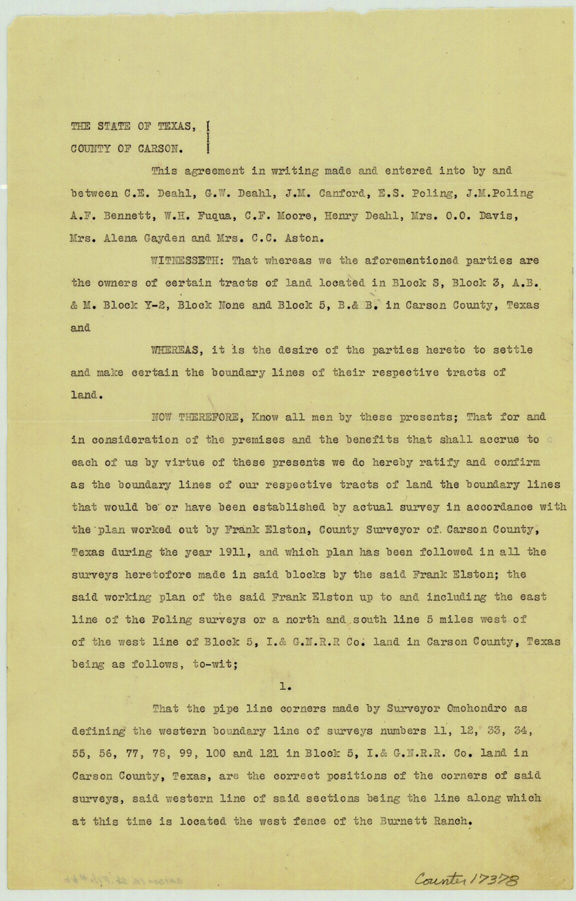
Carson County Sketch File 6b
[Agreement for boundary survey for area in Block Y-2 in northwest part of the county]
-
Map/Doc
17378
-
Collection
General Map Collection
-
Object Dates
1928/12/4 (Creation Date)
1930/3/4 (File Date)
-
Counties
Carson
-
Subjects
Surveying Sketch File
-
Height x Width
13.4 x 8.6 inches
34.0 x 21.8 cm
-
Medium
paper, print
Part of: General Map Collection
Cameron County Sketch File 16

Print $18.00
- Digital $50.00
Cameron County Sketch File 16
1998
Size 11.2 x 8.6 inches
Map/Doc 76334
Austin County Sketch File 6b

Print $50.00
- Digital $50.00
Austin County Sketch File 6b
1894
Size 11.3 x 8.6 inches
Map/Doc 13872
Map of Concho County

Print $20.00
- Digital $50.00
Map of Concho County
1879
Size 25.1 x 18.4 inches
Map/Doc 3436
Hood County Rolled Sketch 5

Print $20.00
- Digital $50.00
Hood County Rolled Sketch 5
1980
Size 29.9 x 32.2 inches
Map/Doc 6221
Flight Mission No. CRC-4R, Frame 159, Chambers County

Print $20.00
- Digital $50.00
Flight Mission No. CRC-4R, Frame 159, Chambers County
1956
Size 18.6 x 22.2 inches
Map/Doc 84918
Brewster County Rolled Sketch 149

Print $20.00
- Digital $50.00
Brewster County Rolled Sketch 149
1951
Size 23.4 x 20.6 inches
Map/Doc 5316
Flight Mission No. DCL-7C, Frame 11, Kenedy County

Print $20.00
- Digital $50.00
Flight Mission No. DCL-7C, Frame 11, Kenedy County
1943
Size 15.4 x 15.2 inches
Map/Doc 86003
Roberts County Rolled Sketch 3

Print $40.00
- Digital $50.00
Roberts County Rolled Sketch 3
Size 37.7 x 48.9 inches
Map/Doc 8359
Llano County Working Sketch Graphic Index

Print $20.00
- Digital $50.00
Llano County Working Sketch Graphic Index
1943
Size 43.7 x 42.6 inches
Map/Doc 76624
Montgomery County

Print $20.00
- Digital $50.00
Montgomery County
1871
Size 21.0 x 24.6 inches
Map/Doc 3891
Texas Official Travel Map

Digital $50.00
Texas Official Travel Map
Size 33.5 x 36.2 inches
Map/Doc 94303
Map of Nacogdoches County

Print $40.00
- Digital $50.00
Map of Nacogdoches County
1839
Size 81.0 x 38.5 inches
Map/Doc 93375
You may also like

Taylor County Working Sketch 21

Print $40.00
- Digital $50.00
Taylor County Working Sketch 21
1985
Size 55.9 x 43.8 inches
Map/Doc 69631
Navigation Maps of Gulf Intracoastal Waterway, Port Arthur to Brownsville, Texas

Print $4.00
- Digital $50.00
Navigation Maps of Gulf Intracoastal Waterway, Port Arthur to Brownsville, Texas
1951
Size 16.8 x 21.6 inches
Map/Doc 65419
Hale County Boundary File 1

Print $44.00
- Digital $50.00
Hale County Boundary File 1
Size 10.0 x 30.9 inches
Map/Doc 54031
Hemphill County Rolled Sketch 2

Print $20.00
- Digital $50.00
Hemphill County Rolled Sketch 2
Size 26.4 x 29.8 inches
Map/Doc 6185
Val Verde County Sketch File Z23

Print $6.00
- Digital $50.00
Val Verde County Sketch File Z23
1919
Size 7.3 x 8.8 inches
Map/Doc 39166
[St. Louis & Southwestern]
![64279, [St. Louis & Southwestern], General Map Collection](https://historictexasmaps.com/wmedia_w700/maps/64279.tif.jpg)
Print $20.00
- Digital $50.00
[St. Louis & Southwestern]
Size 20.7 x 28.5 inches
Map/Doc 64279
Reconnoissance of Sabine River and Valley

Print $20.00
Reconnoissance of Sabine River and Valley
1863
Size 30.2 x 42.3 inches
Map/Doc 97499
[H. & T. C. Block 47 and Vicinity]
![91425, [H. & T. C. Block 47 and Vicinity], Twichell Survey Records](https://historictexasmaps.com/wmedia_w700/maps/91425-1.tif.jpg)
Print $20.00
- Digital $50.00
[H. & T. C. Block 47 and Vicinity]
1882
Size 17.1 x 24.5 inches
Map/Doc 91425
Flight Mission No. BRA-16M, Frame 165, Jefferson County

Print $20.00
- Digital $50.00
Flight Mission No. BRA-16M, Frame 165, Jefferson County
1953
Size 18.6 x 22.4 inches
Map/Doc 85763
Right of Way and Track Map, the Missouri, Kansas and Texas Ry. of Texas - Henrietta Division

Print $20.00
- Digital $50.00
Right of Way and Track Map, the Missouri, Kansas and Texas Ry. of Texas - Henrietta Division
1918
Size 11.8 x 26.9 inches
Map/Doc 64748
Topographical Map of the Rio Grande, Sheet No. 10

Print $20.00
- Digital $50.00
Topographical Map of the Rio Grande, Sheet No. 10
1912
Map/Doc 89534