Duval County Sketch File 31
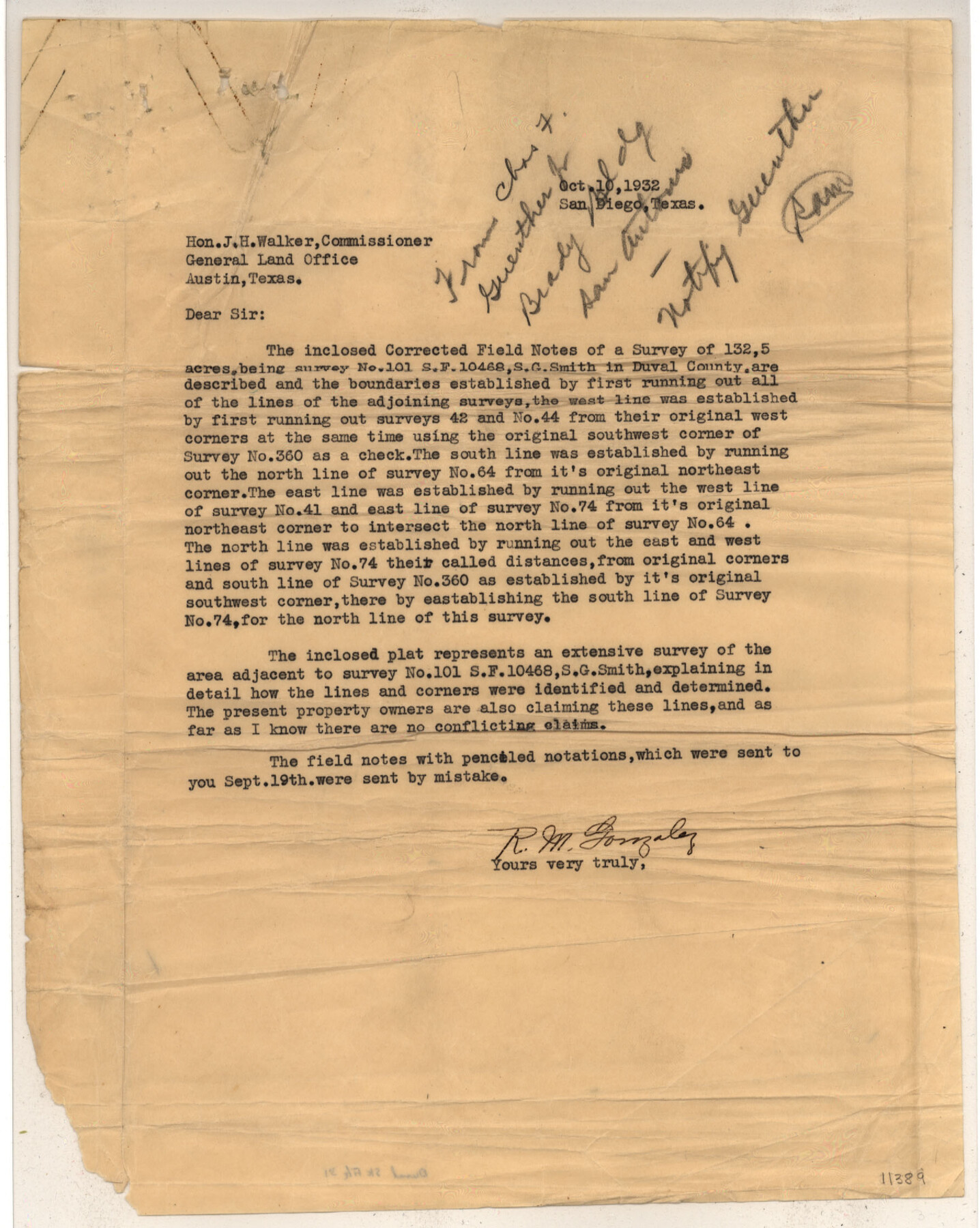
[Letter that accompanied plat showing survey of area adjacent to survey 101, SF-10468]
-
Map/Doc
11389
-
Collection
General Map Collection
-
Object Dates
1932/10/10 (Creation Date)
1932/10/11 (File Date)
1932/9/30 (Survey Date)
-
People and Organizations
R.M. Gonzales (Surveyor/Engineer)
-
Counties
Duval
-
Subjects
Surveying Sketch File
-
Height x Width
29.3 x 17.7 inches
74.4 x 45.0 cm
-
Medium
multi-page, multi-format
-
Scale
1:500
-
Features
County Road
Part of: General Map Collection
Lee County Working Sketch 14

Print $20.00
- Digital $50.00
Lee County Working Sketch 14
1981
Size 17.9 x 11.4 inches
Map/Doc 70393
Austin Street Map & Guide

Digital $50.00
Austin Street Map & Guide
1999
Size 35.4 x 23.2 inches
Map/Doc 94094
Parker County Sketch File 46

Print $26.00
- Digital $50.00
Parker County Sketch File 46
1957
Size 11.2 x 8.5 inches
Map/Doc 33615
Bandera County Boundary File 7

Print $14.00
- Digital $50.00
Bandera County Boundary File 7
Size 12.7 x 8.1 inches
Map/Doc 50306
Floyd County Sketch File 17

Print $12.00
- Digital $50.00
Floyd County Sketch File 17
1913
Size 8.3 x 5.4 inches
Map/Doc 22747
Flight Mission No. BRA-7M, Frame 6, Jefferson County

Print $20.00
- Digital $50.00
Flight Mission No. BRA-7M, Frame 6, Jefferson County
1953
Size 18.5 x 22.3 inches
Map/Doc 85457
Childress County Working Sketch 2

Print $20.00
- Digital $50.00
Childress County Working Sketch 2
1907
Size 17.1 x 14.9 inches
Map/Doc 68018
Culberson County Sketch File 18

Print $8.00
- Digital $50.00
Culberson County Sketch File 18
Size 14.3 x 8.8 inches
Map/Doc 20185
Dimmit County Working Sketch 3

Print $20.00
- Digital $50.00
Dimmit County Working Sketch 3
1911
Size 16.5 x 22.5 inches
Map/Doc 68664
Lavaca County Sketch File 3

Print $8.00
- Digital $50.00
Lavaca County Sketch File 3
1853
Size 10.1 x 9.8 inches
Map/Doc 29633
Menard County Working Sketch 20

Print $20.00
- Digital $50.00
Menard County Working Sketch 20
1947
Size 38.5 x 34.9 inches
Map/Doc 70967
Zavala County Sketch File 50

Print $10.00
- Digital $50.00
Zavala County Sketch File 50
1956
Size 14.6 x 9.1 inches
Map/Doc 41446
You may also like
Grimes County Working Sketch 15

Print $20.00
- Digital $50.00
Grimes County Working Sketch 15
1988
Size 42.4 x 42.4 inches
Map/Doc 63306
Webb County Rolled Sketch 13

Print $20.00
- Digital $50.00
Webb County Rolled Sketch 13
Size 17.6 x 33.8 inches
Map/Doc 8177
Jefferson County Rolled Sketch 34

Print $20.00
- Digital $50.00
Jefferson County Rolled Sketch 34
1957
Size 43.9 x 34.6 inches
Map/Doc 9296
Maverick County Working Sketch 23

Print $20.00
- Digital $50.00
Maverick County Working Sketch 23
1985
Size 37.8 x 36.4 inches
Map/Doc 70915
McLennan County Sketch File 43

Print $4.00
- Digital $50.00
McLennan County Sketch File 43
1873
Size 10.0 x 8.1 inches
Map/Doc 31333
Williamson County

Print $20.00
- Digital $50.00
Williamson County
1919
Size 22.5 x 29.8 inches
Map/Doc 4643
From Citizens of Nacogdoches County for the Creation of a New County to be Called Smith, September 4, 1841

Print $20.00
From Citizens of Nacogdoches County for the Creation of a New County to be Called Smith, September 4, 1841
2020
Size 18.3 x 21.7 inches
Map/Doc 96392
Flight Mission No. DAG-18K, Frame 74, Matagorda County

Print $20.00
- Digital $50.00
Flight Mission No. DAG-18K, Frame 74, Matagorda County
1952
Size 18.5 x 22.4 inches
Map/Doc 86367
Cass County Working Sketch 26

Print $20.00
- Digital $50.00
Cass County Working Sketch 26
1974
Size 32.1 x 28.9 inches
Map/Doc 67929
Concho County Sketch File 37

Print $20.00
- Digital $50.00
Concho County Sketch File 37
1938
Size 18.7 x 29.1 inches
Map/Doc 11162
Austin County Sketch File 17

Print $4.00
- Digital $50.00
Austin County Sketch File 17
1873
Size 5.9 x 8.3 inches
Map/Doc 13925
Harris County Sketch File 26

Print $8.00
- Digital $50.00
Harris County Sketch File 26
Size 9.2 x 8.5 inches
Map/Doc 25393