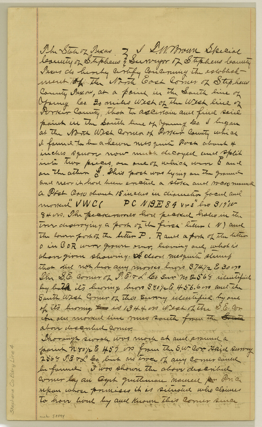
Stephens County Boundary File 4
Report of Survey Establishing N. W. Cor. Palo Pinto and N. E. Co. Stephens Co.
-
Map/Doc
58894
-
Collection
General Map Collection
-
Counties
Stephens
-
Subjects
County Boundaries
-
Height x Width
14.3 x 8.8 inches
36.3 x 22.4 cm
Part of: General Map Collection
Stephens County Working Sketch 3

Print $3.00
- Digital $50.00
Stephens County Working Sketch 3
1919
Size 11.3 x 9.9 inches
Map/Doc 63946
Harris County Sketch File 14

Print $20.00
- Digital $50.00
Harris County Sketch File 14
Size 17.4 x 18.4 inches
Map/Doc 11649
Brewster County Sketch File N-18

Print $14.00
- Digital $50.00
Brewster County Sketch File N-18
1942
Size 14.2 x 8.9 inches
Map/Doc 15690
Crosby County Working Sketch 11

Print $20.00
- Digital $50.00
Crosby County Working Sketch 11
1947
Size 23.7 x 22.8 inches
Map/Doc 68445
Sabine County Sketch File 7a

Print $4.00
Sabine County Sketch File 7a
1882
Size 14.2 x 8.7 inches
Map/Doc 35620
Upshur County Sketch File 3a

Print $2.00
- Digital $50.00
Upshur County Sketch File 3a
Size 6.5 x 7.1 inches
Map/Doc 38736
Cottle County Working Sketch 6

Print $20.00
- Digital $50.00
Cottle County Working Sketch 6
1927
Size 23.0 x 29.3 inches
Map/Doc 68316
Newton County Working Sketch 44

Print $20.00
- Digital $50.00
Newton County Working Sketch 44
1992
Size 19.2 x 24.6 inches
Map/Doc 71290
Pecos County Working Sketch 35

Print $20.00
- Digital $50.00
Pecos County Working Sketch 35
1939
Size 32.5 x 26.7 inches
Map/Doc 71507
Cooke County Sketch File 21

Print $4.00
- Digital $50.00
Cooke County Sketch File 21
Size 9.0 x 6.7 inches
Map/Doc 19265
Controlled Mosaic by Jack Amman Photogrammetric Engineers, Inc - Sheet 39

Print $20.00
- Digital $50.00
Controlled Mosaic by Jack Amman Photogrammetric Engineers, Inc - Sheet 39
1954
Size 20.0 x 24.0 inches
Map/Doc 83494

You may also like
Harrison County Sketch File 21

Print $20.00
- Digital $50.00
Harrison County Sketch File 21
1892
Size 20.2 x 25.7 inches
Map/Doc 11694
Montgomery County Working Sketch 67

Print $20.00
- Digital $50.00
Montgomery County Working Sketch 67
1972
Size 35.0 x 29.6 inches
Map/Doc 71174
General Highway Map, Marion County, Texas

Print $20.00
General Highway Map, Marion County, Texas
1961
Size 18.2 x 24.6 inches
Map/Doc 79582

Rusk County Working Sketch Graphic Index

Print $20.00
- Digital $50.00
Rusk County Working Sketch Graphic Index
1932
Size 45.6 x 34.9 inches
Map/Doc 76688
Taylor County Sketch File 5

Print $4.00
- Digital $50.00
Taylor County Sketch File 5
Size 9.3 x 7.8 inches
Map/Doc 37781
Brazos River, Fresno Sheet

Print $20.00
- Digital $50.00
Brazos River, Fresno Sheet
1938
Size 31.3 x 38.4 inches
Map/Doc 65289
General Land Office and State Reclamation Department - An Index Map

Print $20.00
- Digital $50.00
General Land Office and State Reclamation Department - An Index Map
1930
Size 26.2 x 16.6 inches
Map/Doc 65069
Kendall County Sketch File 8

Print $4.00
- Digital $50.00
Kendall County Sketch File 8
1879
Size 10.1 x 8.0 inches
Map/Doc 28690
[University Lands Block 16 and Blocks 194, Z and part of 12]
![91618, [University Lands Block 16 and Blocks 194, Z and part of 12], Twichell Survey Records](https://historictexasmaps.com/wmedia_w700/maps/91618-1.tif.jpg)
Print $20.00
- Digital $50.00
[University Lands Block 16 and Blocks 194, Z and part of 12]
1911
Size 32.2 x 23.3 inches
Map/Doc 91618
Lubbock County Working Sketch Graphic Index

Print $20.00
- Digital $50.00
Lubbock County Working Sketch Graphic Index
1968
Size 41.3 x 33.7 inches
Map/Doc 76626
