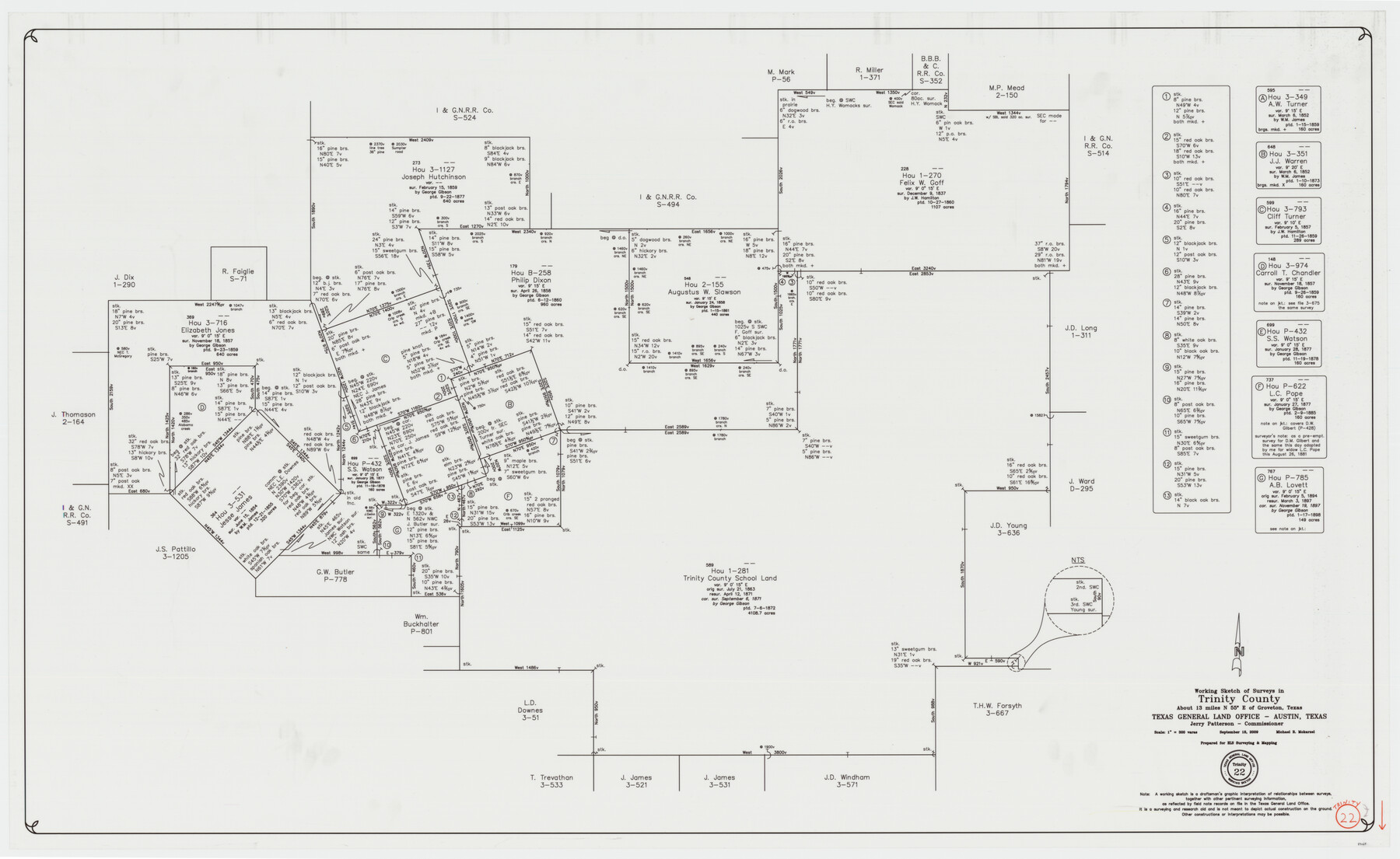
Trinity County Working Sketch 22
-
Map/Doc
89068
-
Collection
General Map Collection
-
Object Dates
9/18/2009 (Creation Date)
-
People and Organizations
Jerry E. Patterson (GLO Commissioner)
Michael R. Mokarzel (Draftsman)
-
Counties
Trinity
-
Subjects
Surveying Working Sketch
-
Height x Width
32.0 x 52.1 inches
81.3 x 132.3 cm
-
Scale
1" = 300 varas
Part of: General Map Collection
Travis County Rolled Sketch 61

Print $20.00
- Digital $50.00
Travis County Rolled Sketch 61
2023
Size 36.0 x 24.0 inches
Map/Doc 97184
Duval County Sketch File 8d

Print $4.00
- Digital $50.00
Duval County Sketch File 8d
1869
Size 10.8 x 8.9 inches
Map/Doc 21302
Nolan County Working Sketch 9

Print $20.00
- Digital $50.00
Nolan County Working Sketch 9
1964
Size 25.0 x 36.8 inches
Map/Doc 71300
[Sketch of Surveys on Big Sandy Creek]
![179, [Sketch of Surveys on Big Sandy Creek], General Map Collection](https://historictexasmaps.com/wmedia_w700/maps/179.tif.jpg)
Print $2.00
- Digital $50.00
[Sketch of Surveys on Big Sandy Creek]
1841
Size 8.2 x 9.2 inches
Map/Doc 179
Map of section no. 12 of a survey of Padre Island made for the Office of the Attorney General of the State of Texas

Print $40.00
- Digital $50.00
Map of section no. 12 of a survey of Padre Island made for the Office of the Attorney General of the State of Texas
1941
Size 75.9 x 41.0 inches
Map/Doc 2268
Jeff Davis County Rolled Sketch 42

Print $20.00
- Digital $50.00
Jeff Davis County Rolled Sketch 42
1998
Size 26.8 x 18.9 inches
Map/Doc 76415
Caddo Lake and Subdivision

Print $20.00
- Digital $50.00
Caddo Lake and Subdivision
1918
Size 35.0 x 29.8 inches
Map/Doc 93283
Orange County Rolled Sketch 26

Print $20.00
- Digital $50.00
Orange County Rolled Sketch 26
1952
Size 35.2 x 43.0 inches
Map/Doc 9649
Flight Mission No. DQN-1K, Frame 142, Calhoun County

Print $20.00
- Digital $50.00
Flight Mission No. DQN-1K, Frame 142, Calhoun County
1953
Size 18.8 x 22.3 inches
Map/Doc 84205
Crockett County Rolled Sketch 65

Print $20.00
- Digital $50.00
Crockett County Rolled Sketch 65
1948
Size 13.4 x 27.5 inches
Map/Doc 5608
Calhoun County

Print $20.00
- Digital $50.00
Calhoun County
1882
Size 22.7 x 18.7 inches
Map/Doc 3359
Concho County Boundary File 4

Print $2.00
- Digital $50.00
Concho County Boundary File 4
Size 12.7 x 8.4 inches
Map/Doc 51825
You may also like
Brewster County Rolled Sketch B

Print $40.00
- Digital $50.00
Brewster County Rolled Sketch B
1882
Size 67.4 x 37.7 inches
Map/Doc 8465
Ellis County Sketch File 19

Print $6.00
- Digital $50.00
Ellis County Sketch File 19
1863
Size 12.4 x 7.8 inches
Map/Doc 21866
Hansford County Sketch File 2

Print $13.00
- Digital $50.00
Hansford County Sketch File 2
1901
Size 76.7 x 25.5 inches
Map/Doc 10476
Sketches of Surveys in Montgomery Co.

Print $2.00
- Digital $50.00
Sketches of Surveys in Montgomery Co.
1845
Size 10.2 x 8.0 inches
Map/Doc 69731
Crane County Working Sketch 20

Print $40.00
- Digital $50.00
Crane County Working Sketch 20
1958
Size 61.8 x 38.1 inches
Map/Doc 68297
Schleicher County

Print $40.00
- Digital $50.00
Schleicher County
1898
Size 35.0 x 52.8 inches
Map/Doc 78396
Fort Bend County Rolled Sketch T

Print $20.00
- Digital $50.00
Fort Bend County Rolled Sketch T
1930
Size 28.7 x 25.8 inches
Map/Doc 5908
Presidio County Rolled Sketch 90

Print $20.00
- Digital $50.00
Presidio County Rolled Sketch 90
1947
Size 20.5 x 24.4 inches
Map/Doc 7375
Stonewall County Rolled Sketch 34

Print $20.00
- Digital $50.00
Stonewall County Rolled Sketch 34
Size 37.5 x 30.2 inches
Map/Doc 7878
Pecos County Rolled Sketch DK2

Print $20.00
- Digital $50.00
Pecos County Rolled Sketch DK2
1938
Size 31.8 x 40.0 inches
Map/Doc 9714
Kent County Boundary File 7

Print $6.00
- Digital $50.00
Kent County Boundary File 7
Size 10.8 x 8.7 inches
Map/Doc 55870
Map from Corpus Christi to Matagorda Bays, Texas [Inset: Survey of the channel of Copono Bay]
![72973, Map from Corpus Christi to Matagorda Bays, Texas [Inset: Survey of the channel of Copono Bay], General Map Collection](https://historictexasmaps.com/wmedia_w700/maps/72973.tif.jpg)
Print $20.00
- Digital $50.00
Map from Corpus Christi to Matagorda Bays, Texas [Inset: Survey of the channel of Copono Bay]
1846
Size 18.2 x 27.5 inches
Map/Doc 72973