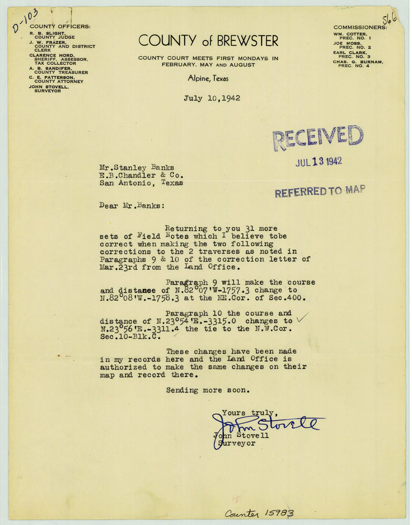
Brewster County Sketch File NS-5
[Correspondence relating to "O2" Ranch, east and west part]
-
Map/Doc
15983
-
Collection
General Map Collection
-
Object Dates
1942/7/10 (Correspondence Date)
1942/7/15 (Correspondence Date)
1941/12/6 (Correspondence Date)
1942/7/19 (Correspondence Date)
1942/7/26 (Correspondence Date)
1942/8/29 (Correspondence Date)
1942/8/10 (Correspondence Date)
1942/9/13 (Correspondence Date)
1943/7/20 (File Date)
-
People and Organizations
John Stovell (Surveyor/Engineer)
-
Counties
Brewster Presidio
-
Subjects
Surveying Sketch File
-
Height x Width
11.2 x 8.8 inches
28.4 x 22.4 cm
-
Medium
paper, print
-
Comments
See Brewster County Rolled Sketch 62 (8487) and Brewster County Rolled Sketch 63 (8488).
Related maps
Brewster County Rolled Sketch 62

Print $40.00
- Digital $50.00
Brewster County Rolled Sketch 62
1939
Size 89.5 x 44.0 inches
Map/Doc 8487
Brewster County Rolled Sketch 63

Print $40.00
- Digital $50.00
Brewster County Rolled Sketch 63
1939
Size 77.1 x 43.6 inches
Map/Doc 8488
Part of: General Map Collection
Liberty County Sketch File 21

Print $5.00
- Digital $50.00
Liberty County Sketch File 21
1858
Size 7.9 x 13.0 inches
Map/Doc 29928
Texas Official Highway Travel Map

Texas Official Highway Travel Map
Size 27.3 x 36.4 inches
Map/Doc 94308

Cameron County Rolled Sketch 28C

Print $20.00
- Digital $50.00
Cameron County Rolled Sketch 28C
Size 20.3 x 16.3 inches
Map/Doc 5393
Kaufman County Boundary File 1a

Print $8.00
- Digital $50.00
Kaufman County Boundary File 1a
Size 14.1 x 8.6 inches
Map/Doc 55907
Cottle County Rolled Sketch 11

Print $20.00
- Digital $50.00
Cottle County Rolled Sketch 11
1927
Size 31.6 x 24.1 inches
Map/Doc 5568
Map of Granbury

Print $20.00
- Digital $50.00
Map of Granbury
1960
Size 23.5 x 26.7 inches
Map/Doc 3041
Hunt County Sketch File 1

Print $4.00
- Digital $50.00
Hunt County Sketch File 1
1853
Size 7.6 x 5.1 inches
Map/Doc 27081
Harris County Working Sketch 95

Print $20.00
- Digital $50.00
Harris County Working Sketch 95
1978
Size 26.6 x 44.1 inches
Map/Doc 65987
Current Miscellaneous File 113

Print $52.00
- Digital $50.00
Current Miscellaneous File 113
Size 23.8 x 17.1 inches
Map/Doc 74787
Harris County Working Sketch 74

Print $20.00
- Digital $50.00
Harris County Working Sketch 74
1959
Size 25.7 x 30.0 inches
Map/Doc 65966
Flight Mission No. DQO-2K, Frame 135, Galveston County

Print $20.00
- Digital $50.00
Flight Mission No. DQO-2K, Frame 135, Galveston County
1952
Size 18.7 x 22.5 inches
Map/Doc 85032
You may also like
Flight Mission No. DAG-14K, Frame 145, Matagorda County

Print $20.00
- Digital $50.00
Flight Mission No. DAG-14K, Frame 145, Matagorda County
1952
Size 18.6 x 22.6 inches
Map/Doc 86312
General Highway Map, Hemphill County, Texas

Print $20.00
General Highway Map, Hemphill County, Texas
1961
Size 18.3 x 24.6 inches
Map/Doc 79515
Hunt County Sketch File 20

Print $4.00
- Digital $50.00
Hunt County Sketch File 20
1853
Size 8.3 x 7.9 inches
Map/Doc 27120
Crosby County Sketch File 4

Print $4.00
- Digital $50.00
Crosby County Sketch File 4
Size 8.6 x 12.6 inches
Map/Doc 20000
Swisher County Working Sketch 4

Print $20.00
- Digital $50.00
Swisher County Working Sketch 4
1960
Size 23.0 x 19.9 inches
Map/Doc 62415
[F. W. & D. C. Ry. Co. Alignment and Right of Way Map, Clay County]
![64735, [F. W. & D. C. Ry. Co. Alignment and Right of Way Map, Clay County], General Map Collection](https://historictexasmaps.com/wmedia_w700/maps/64735-GC.tif.jpg)
Print $20.00
- Digital $50.00
[F. W. & D. C. Ry. Co. Alignment and Right of Way Map, Clay County]
1927
Size 18.6 x 11.8 inches
Map/Doc 64735
Atascosa County Working Sketch 24

Print $20.00
- Digital $50.00
Atascosa County Working Sketch 24
1958
Size 34.0 x 43.1 inches
Map/Doc 67220
[I. & G. N. Block 1]
![91588, [I. & G. N. Block 1], Twichell Survey Records](https://historictexasmaps.com/wmedia_w700/maps/91588-1.tif.jpg)
Print $20.00
- Digital $50.00
[I. & G. N. Block 1]
Size 11.8 x 18.6 inches
Map/Doc 91588
[Surveys in the Bexar District along the Balcones, Cibolo and Leon Creeks]
![63, [Surveys in the Bexar District along the Balcones, Cibolo and Leon Creeks], General Map Collection](https://historictexasmaps.com/wmedia_w700/maps/63.tif.jpg)
Print $3.00
- Digital $50.00
[Surveys in the Bexar District along the Balcones, Cibolo and Leon Creeks]
1842
Size 10.6 x 12.4 inches
Map/Doc 63
Duval County Rolled Sketch HO and R

Print $40.00
- Digital $50.00
Duval County Rolled Sketch HO and R
1933
Size 65.8 x 43.1 inches
Map/Doc 8807
El Paso County Working Sketch 19

Print $20.00
- Digital $50.00
El Paso County Working Sketch 19
1960
Size 20.8 x 20.8 inches
Map/Doc 69041
Upton County Rolled Sketch 26

Print $20.00
- Digital $50.00
Upton County Rolled Sketch 26
1942
Size 35.7 x 37.2 inches
Map/Doc 10045