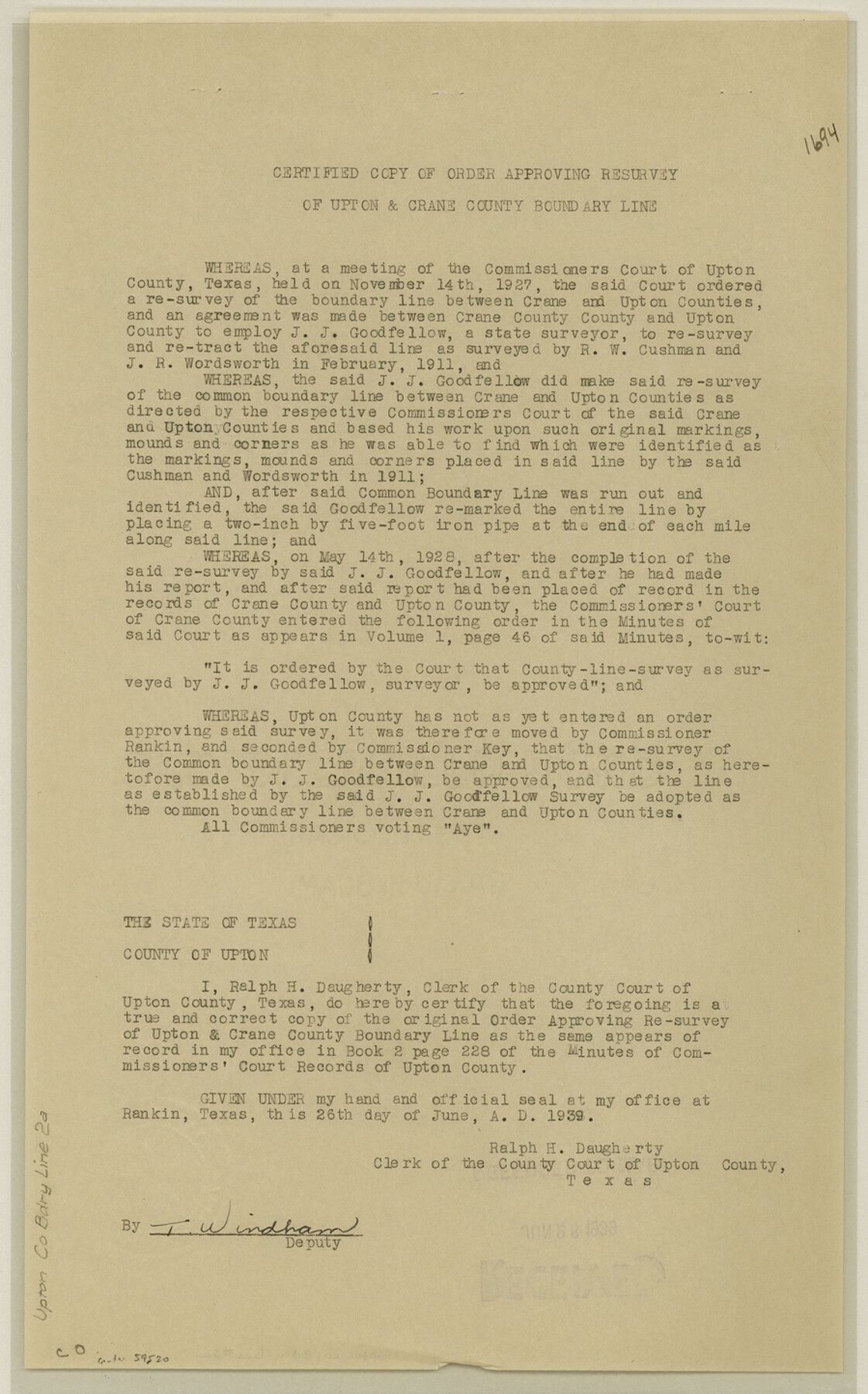
Upton County Boundary File 2a
Certified Copy of Order Approving Resurvey of Upton & Crane County Boundary Line; Certified Copy of Report of Resurvey by J. J. Goodfellow, Special Survey Crane and Upton County Boundary
-
Map/Doc
59520
-
Collection
General Map Collection
-
Counties
Upton
-
Subjects
County Boundaries
-
Height x Width
14.4 x 9.0 inches
36.6 x 22.9 cm
Part of: General Map Collection
Brewster County Rolled Sketch 134

Print $20.00
- Digital $50.00
Brewster County Rolled Sketch 134
Size 19.0 x 24.9 inches
Map/Doc 5303
Baylor County Sketch File 11B

Print $20.00
- Digital $50.00
Baylor County Sketch File 11B
1892
Map/Doc 88490
University Lands Blocks 38 to 57, Crockett-Reagan-Irion-Schleicher-Counties

Print $40.00
- Digital $50.00
University Lands Blocks 38 to 57, Crockett-Reagan-Irion-Schleicher-Counties
1937
Size 34.2 x 52.7 inches
Map/Doc 2444
Kendall County Working Sketch 1

Print $20.00
- Digital $50.00
Kendall County Working Sketch 1
1911
Size 18.8 x 17.6 inches
Map/Doc 66673
Pecos County Working Sketch 15

Print $20.00
- Digital $50.00
Pecos County Working Sketch 15
1914
Size 29.8 x 15.4 inches
Map/Doc 71485
Crockett County Rolled Sketch 63

Print $20.00
- Digital $50.00
Crockett County Rolled Sketch 63
1947
Size 18.9 x 30.8 inches
Map/Doc 5606
Fannin County Sketch File 13

Print $4.00
- Digital $50.00
Fannin County Sketch File 13
Size 8.1 x 7.9 inches
Map/Doc 22462
Palo Duro Canyon Park

Print $20.00
- Digital $50.00
Palo Duro Canyon Park
1950
Size 25.2 x 37.9 inches
Map/Doc 73567
San Patricio County Working Sketch 8

Print $20.00
- Digital $50.00
San Patricio County Working Sketch 8
1936
Size 26.9 x 21.5 inches
Map/Doc 63770
Current Miscellaneous File 119

Print $10.00
- Digital $50.00
Current Miscellaneous File 119
1990
Size 8.5 x 10.9 inches
Map/Doc 83397
Burleson County Working Sketch 2

Print $20.00
- Digital $50.00
Burleson County Working Sketch 2
1976
Size 36.4 x 31.2 inches
Map/Doc 67721
Zapata County Rolled Sketch 17A

Print $40.00
- Digital $50.00
Zapata County Rolled Sketch 17A
1953
Size 40.6 x 52.2 inches
Map/Doc 10170
You may also like
Map of Georgia, Florida, Alabama, Mississippi and Tennessee engraved to illustrate Mitchell's new intermediate geography

Print $20.00
- Digital $50.00
Map of Georgia, Florida, Alabama, Mississippi and Tennessee engraved to illustrate Mitchell's new intermediate geography
1885
Size 12.2 x 9.0 inches
Map/Doc 93518
[Sketch N, showing Blocks C-10, C-14 through C-16]
![91772, [Sketch N, showing Blocks C-10, C-14 through C-16], Twichell Survey Records](https://historictexasmaps.com/wmedia_w700/maps/91772-1.tif.jpg)
Print $20.00
- Digital $50.00
[Sketch N, showing Blocks C-10, C-14 through C-16]
Size 38.6 x 22.1 inches
Map/Doc 91772
Webb County Sketch File 3a

Print $40.00
- Digital $50.00
Webb County Sketch File 3a
1855
Size 32.1 x 20.8 inches
Map/Doc 12613
Borden County Sketch File 12

Print $24.00
- Digital $50.00
Borden County Sketch File 12
Size 10.8 x 9.1 inches
Map/Doc 14732
General Highway Map, Cameron County, Texas

Print $20.00
General Highway Map, Cameron County, Texas
1961
Size 18.3 x 24.7 inches
Map/Doc 79398
San Patricio County Sketch File 42

Print $89.00
- Digital $50.00
San Patricio County Sketch File 42
1979
Size 11.3 x 8.8 inches
Map/Doc 36240
Crockett County Rolled Sketch 88M

Print $20.00
- Digital $50.00
Crockett County Rolled Sketch 88M
1964
Size 25.2 x 34.2 inches
Map/Doc 5629
Nueces County Sketch File 85

Print $2.00
- Digital $50.00
Nueces County Sketch File 85
Size 11.0 x 8.5 inches
Map/Doc 82922
Map of La Salle County

Print $20.00
- Digital $50.00
Map of La Salle County
1878
Size 29.8 x 24.8 inches
Map/Doc 3798

Harris County Rolled Sketch T2

Print $20.00
- Digital $50.00
Harris County Rolled Sketch T2
1916
Size 26.8 x 23.2 inches
Map/Doc 6145
Flight Mission No. DIX-10P, Frame 182, Aransas County

Print $20.00
- Digital $50.00
Flight Mission No. DIX-10P, Frame 182, Aransas County
1956
Size 18.6 x 22.3 inches
Map/Doc 83972