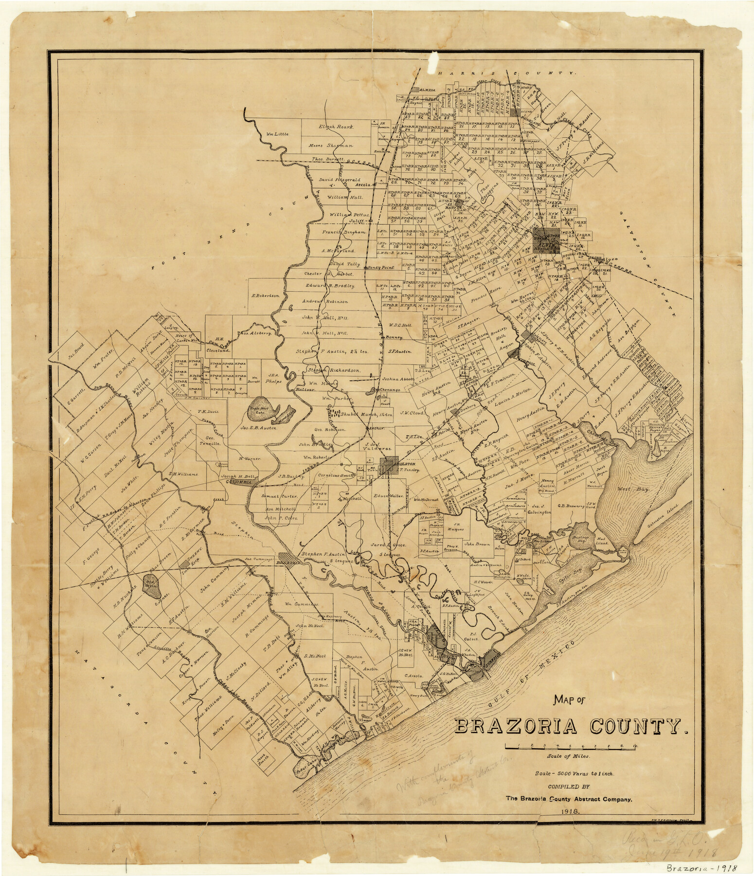
Map of Brazoria County
-
Map/Doc
1518
-
Collection
General Map Collection
-
Object Dates
1918 (Creation Date)
-
People and Organizations
The Brazoria County Abstract Company (Publisher)
Brazoria County Abstract Company (Compiler)
P.W. Stevens (Draftsman)
F.K. Stevens (Draftsman)
-
Counties
Brazoria
-
Subjects
County
-
Height x Width
26.1 x 22.6 inches
66.3 x 57.4 cm
-
Comments
Received in General Land Office June 19, 1918 with compliments of the Brazoria County Abstract Company.
-
Features
Blacks Road Ferry
Gravel Road
H&BV
Clute
Brazos River
LJRR
Brazoria
Overlong's Ferry
Sweeny
Old Orsaka [Lake]
Railroad Grade to Wharton
Big Slough
Lutors Creek
Blacks Road
Rice Canals
Cox Lake
Bastrop Bayou
Bastrop Bay
Mud Island
Galveston Island
West Bay
Freeport
Clear Lake
Gulf of Mexico
Barrows [Lake]
Churchills [Ferry]
Cedar Lake Bayou
Linnville Bayou
Mirrons Bridge
Hindles Ferry
Jones Creek
Chocolate Bay
Bryan Heights
Quintana
West Union Bayou
Surfside
Oyster Bay Canal
San Luis Pass
San Luis Island
Bastrop Bay
Oyster Bay
Juliff
Halls Bayou
Mustang Slough
Liverpool
Chocolate Bayou
I&GN
Cow Creek
Airline Road
Dolores
Algoa
Danbury
Manvel
Arcola
GC&SF
Oyster Creek
Alvin
Sandy Point
Brazos River
Pearland
Clear Creek
Mound Creek
Big Mound
Austin's Bayou
Brushy Bayou
SLB&M
Angleton
Long Pond
Kaiser Mound
Underwood's [house]
San Bernard River
Almeda
Varner's Creek
Manor Lake
Eagle Nest Lake
Bolivar
Jennings Bayou
TSR
Anchor
Chenango
Flores Bayou
Part of: General Map Collection
Flight Mission No. CRK-3P, Frame 66, Refugio County

Print $20.00
- Digital $50.00
Flight Mission No. CRK-3P, Frame 66, Refugio County
1956
Size 18.6 x 22.4 inches
Map/Doc 86908
Dallas County Working Sketch 14

Print $20.00
- Digital $50.00
Dallas County Working Sketch 14
1987
Size 31.2 x 21.7 inches
Map/Doc 68580
Trinity County Working Sketch 9

Print $20.00
- Digital $50.00
Trinity County Working Sketch 9
1947
Size 23.5 x 28.1 inches
Map/Doc 69458
La Salle County Sketch File 38

Print $40.00
- Digital $50.00
La Salle County Sketch File 38
Size 13.7 x 14.5 inches
Map/Doc 29590
Hunt County Boundary File 10

Print $14.00
- Digital $50.00
Hunt County Boundary File 10
Size 9.2 x 14.9 inches
Map/Doc 55255
Foard County Sketch File 23

Print $20.00
- Digital $50.00
Foard County Sketch File 23
1891
Size 21.3 x 24.7 inches
Map/Doc 4544
La Salle County

Print $20.00
- Digital $50.00
La Salle County
1923
Size 39.7 x 34.5 inches
Map/Doc 77348
Wilbarger County Sketch File 22

Print $4.00
- Digital $50.00
Wilbarger County Sketch File 22
1889
Size 9.7 x 6.2 inches
Map/Doc 40221
Calhoun County

Print $20.00
- Digital $50.00
Calhoun County
1883
Size 22.9 x 19.1 inches
Map/Doc 66741

E. N. Gustafson's survey of Southern Portion of Lake Austin, Matagorda Co., TX

Print $20.00
- Digital $50.00
E. N. Gustafson's survey of Southern Portion of Lake Austin, Matagorda Co., TX
1926
Size 36.7 x 42.7 inches
Map/Doc 2922
Coleman County Working Sketch 5

Print $20.00
- Digital $50.00
Coleman County Working Sketch 5
1928
Size 27.0 x 25.6 inches
Map/Doc 68071
You may also like
Grayson County Rolled Sketch 1

Print $20.00
- Digital $50.00
Grayson County Rolled Sketch 1
1944
Size 43.4 x 29.0 inches
Map/Doc 6029
Newton County Working Sketch 2

Print $20.00
- Digital $50.00
Newton County Working Sketch 2
1905
Size 14.5 x 19.3 inches
Map/Doc 71248
Kendall County Sketch File 20

Print $42.00
- Digital $50.00
Kendall County Sketch File 20
1916
Size 9.7 x 6.3 inches
Map/Doc 28713
Bosque County Sketch File 30a

Print $8.00
- Digital $50.00
Bosque County Sketch File 30a
1854
Size 14.4 x 8.7 inches
Map/Doc 14822
Kimble County Working Sketch 57

Print $20.00
- Digital $50.00
Kimble County Working Sketch 57
1958
Size 20.3 x 30.5 inches
Map/Doc 70125
Map of Upshur County Showing Location T&P R.

Print $20.00
- Digital $50.00
Map of Upshur County Showing Location T&P R.
1872
Size 26.5 x 19.4 inches
Map/Doc 64137
Coryell County Sketch File 24

Print $24.00
- Digital $50.00
Coryell County Sketch File 24
1965
Size 11.2 x 8.8 inches
Map/Doc 19389
Webb County Working Sketch 34

Print $20.00
- Digital $50.00
Webb County Working Sketch 34
1938
Size 23.8 x 24.3 inches
Map/Doc 72399
Map of Pecos and Reeves Counties

Print $40.00
- Digital $50.00
Map of Pecos and Reeves Counties
1873
Size 45.3 x 115.6 inches
Map/Doc 75930
Randall County

Print $20.00
- Digital $50.00
Randall County
1917
Size 44.7 x 36.9 inches
Map/Doc 16793
Karnes County Sketch File 4

Print $8.00
- Digital $50.00
Karnes County Sketch File 4
1852
Size 5.5 x 6.8 inches
Map/Doc 28550
Hudspeth County Working Sketch 27

Print $40.00
- Digital $50.00
Hudspeth County Working Sketch 27
1972
Size 31.0 x 51.2 inches
Map/Doc 66309