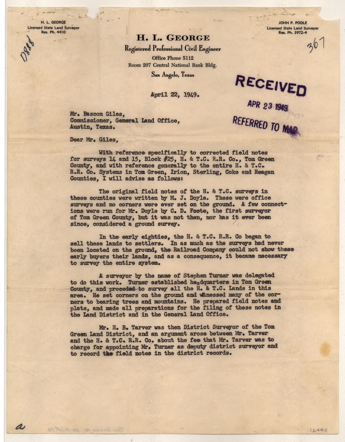
Tom Green County Sketch File 72
[Sketch of sections 13, 14, 15, & 16, H. & T. C. R.R. Co. Block 25 and surveyor's statement regarding the Turner corners]
-
Map/Doc
12448
-
Collection
General Map Collection
-
Object Dates
4/1949 (Creation Date)
4/28/1949 (File Date)
-
People and Organizations
H.L. George (Surveyor/Engineer)
-
Counties
Tom Green
-
Subjects
Surveying Sketch File
-
Height x Width
24.3 x 28.5 inches
61.7 x 72.4 cm
-
Medium
multi-page, multi-format
Part of: General Map Collection
Roberts County

Print $20.00
- Digital $50.00
Roberts County
1932
Size 39.7 x 35.8 inches
Map/Doc 77408
Galveston County Sketch File 45

Print $20.00
- Digital $50.00
Galveston County Sketch File 45
1930
Size 19.5 x 23.2 inches
Map/Doc 11540
Maps of Gulf Intracoastal Waterway, Texas - Sabine River to the Rio Grande and connecting waterways including ship channels

Print $20.00
- Digital $50.00
Maps of Gulf Intracoastal Waterway, Texas - Sabine River to the Rio Grande and connecting waterways including ship channels
1966
Size 14.6 x 22.2 inches
Map/Doc 61958
Liberty County Rolled Sketch OB

Print $40.00
- Digital $50.00
Liberty County Rolled Sketch OB
1934
Size 71.0 x 24.8 inches
Map/Doc 9563
Boundary Between the United States & Mexico Agreed upon by the Joint Commission under the Treaty of Guadalupe Hidalgo

Print $20.00
- Digital $50.00
Boundary Between the United States & Mexico Agreed upon by the Joint Commission under the Treaty of Guadalupe Hidalgo
1853
Size 18.3 x 26.7 inches
Map/Doc 72885
Scurry County Working Sketch 7

Print $20.00
- Digital $50.00
Scurry County Working Sketch 7
1971
Size 33.5 x 29.0 inches
Map/Doc 63836
Milam County Working Sketch 17

Print $40.00
- Digital $50.00
Milam County Working Sketch 17
1972
Size 54.7 x 32.2 inches
Map/Doc 89031
Polk County Sketch File 9

Print $28.00
- Digital $50.00
Polk County Sketch File 9
1861
Size 11.9 x 7.7 inches
Map/Doc 34136
Flight Mission No. BRE-2P, Frame 76, Nueces County

Print $20.00
- Digital $50.00
Flight Mission No. BRE-2P, Frame 76, Nueces County
1956
Size 18.4 x 22.4 inches
Map/Doc 86771
Red River County

Print $40.00
- Digital $50.00
Red River County
1934
Size 52.0 x 41.3 inches
Map/Doc 66995
Comanche County Boundary File 2b

Print $12.00
- Digital $50.00
Comanche County Boundary File 2b
Size 14.3 x 8.9 inches
Map/Doc 51790
Llano County Sketch File 12

Print $14.00
- Digital $50.00
Llano County Sketch File 12
1889
Size 14.0 x 8.5 inches
Map/Doc 30380
You may also like
Section 77, Block "A", Sylvan Sanders Survey

Print $20.00
- Digital $50.00
Section 77, Block "A", Sylvan Sanders Survey
1953
Size 24.7 x 16.0 inches
Map/Doc 92716
Presidio County Rolled Sketch A-2A

Print $20.00
- Digital $50.00
Presidio County Rolled Sketch A-2A
Size 34.1 x 15.9 inches
Map/Doc 7406
Moore County Sketch File 5

Print $22.00
- Digital $50.00
Moore County Sketch File 5
Size 9.0 x 12.6 inches
Map/Doc 31937
Tyler County Sketch File 9a

Print $4.00
- Digital $50.00
Tyler County Sketch File 9a
1877
Size 8.1 x 7.7 inches
Map/Doc 38646
San Patricio County Rolled Sketch 53D

Print $20.00
- Digital $50.00
San Patricio County Rolled Sketch 53D
Size 20.1 x 22.1 inches
Map/Doc 7739
Crockett County Sketch File 78

Print $20.00
- Digital $50.00
Crockett County Sketch File 78
1931
Size 29.4 x 19.1 inches
Map/Doc 11235
Reeves County Rolled Sketch 20

Print $20.00
- Digital $50.00
Reeves County Rolled Sketch 20
Size 32.1 x 38.4 inches
Map/Doc 9852
Township 13 South Ranges 14 and 15 West, South Western District, Louisiana

Print $20.00
- Digital $50.00
Township 13 South Ranges 14 and 15 West, South Western District, Louisiana
1838
Size 19.6 x 24.8 inches
Map/Doc 65857
International Railroad Map & Profile of the Second Fifty Miles East of Brazos River

Print $40.00
- Digital $50.00
International Railroad Map & Profile of the Second Fifty Miles East of Brazos River
1877
Size 19.8 x 76.6 inches
Map/Doc 64465
Brown County Sketch File 24

Print $6.00
- Digital $50.00
Brown County Sketch File 24
1889
Size 11.7 x 15.9 inches
Map/Doc 11022
Map of Kinney County

Print $20.00
- Digital $50.00
Map of Kinney County
1875
Size 25.9 x 34.2 inches
Map/Doc 3773
Presidio County Sketch File 36

Print $10.00
- Digital $50.00
Presidio County Sketch File 36
1908
Size 10.4 x 8.2 inches
Map/Doc 34486