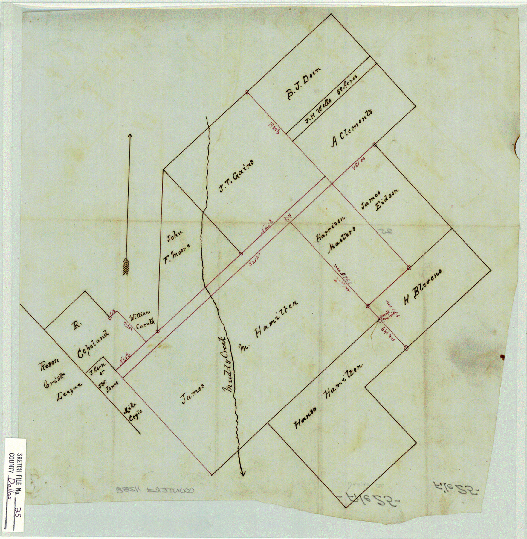
Dallas County Sketch File 25
[Sketch of surveys in the vicinity of Muddy Creek in the northeast corner of the county]
-
Map/Doc
11288
-
Collection
General Map Collection
-
Counties
Dallas Rockwall
-
Subjects
Surveying Sketch File
-
Height x Width
14.9 x 14.6 inches
37.9 x 37.1 cm
-
Medium
paper, manuscript
-
Features
Muddy Creek
Part of: General Map Collection
Kimble County Working Sketch 20

Print $20.00
- Digital $50.00
Kimble County Working Sketch 20
1929
Size 36.2 x 27.8 inches
Map/Doc 70088
Calhoun County Rolled Sketch 11

Print $20.00
- Digital $50.00
Calhoun County Rolled Sketch 11
1942
Size 10.6 x 40.7 inches
Map/Doc 5367

Intracoastal Waterway in Texas - Corpus Christi to Point Isabel including Arroyo Colorado to Mo. Pac. R.R. Bridge Near Harlingen

Print $20.00
- Digital $50.00
Intracoastal Waterway in Texas - Corpus Christi to Point Isabel including Arroyo Colorado to Mo. Pac. R.R. Bridge Near Harlingen
1934
Size 22.0 x 32.7 inches
Map/Doc 61884
Gulf Intracoastal Waterway, Tex. - Aransas Bay to Corpus Christi Bay - Modified Route of Main Channel/Dredging

Print $20.00
- Digital $50.00
Gulf Intracoastal Waterway, Tex. - Aransas Bay to Corpus Christi Bay - Modified Route of Main Channel/Dredging
1958
Size 31.0 x 42.8 inches
Map/Doc 61893
Reeves County Rolled Sketch 1

Print $40.00
- Digital $50.00
Reeves County Rolled Sketch 1
Size 52.9 x 38.5 inches
Map/Doc 9844
Parker County Sketch File 13

Print $4.00
- Digital $50.00
Parker County Sketch File 13
1860
Size 12.1 x 8.0 inches
Map/Doc 33546
Val Verde County Sketch File B2

Print $20.00
- Digital $50.00
Val Verde County Sketch File B2
1910
Size 24.5 x 12.2 inches
Map/Doc 12544
Gaines County

Print $40.00
- Digital $50.00
Gaines County
1901
Size 41.3 x 57.2 inches
Map/Doc 16833
Zavala County Working Sketch 5

Print $20.00
- Digital $50.00
Zavala County Working Sketch 5
1940
Size 29.6 x 14.3 inches
Map/Doc 62080
The Texas and Pacific Ry. Co., Station Map, Loraine, Texas

Print $20.00
- Digital $50.00
The Texas and Pacific Ry. Co., Station Map, Loraine, Texas
Size 11.6 x 18.6 inches
Map/Doc 64683
Hays County Sketch File 8

Print $4.00
- Digital $50.00
Hays County Sketch File 8
1848
Size 5.5 x 7.8 inches
Map/Doc 26210
You may also like
General Highway Map, Victoria County, Texas

Print $20.00
General Highway Map, Victoria County, Texas
1940
Size 24.8 x 18.5 inches
Map/Doc 79268
Duval County Working Sketch 18

Print $20.00
- Digital $50.00
Duval County Working Sketch 18
1939
Size 23.5 x 19.6 inches
Map/Doc 68731
Hutchinson County Map

Print $20.00
- Digital $50.00
Hutchinson County Map
Size 18.1 x 19.4 inches
Map/Doc 91185
St. Louis, Brownsville & Mexico

Print $40.00
- Digital $50.00
St. Louis, Brownsville & Mexico
1906
Size 20.0 x 127.8 inches
Map/Doc 89281
Floyd County Sketch File 6

Print $2.00
- Digital $50.00
Floyd County Sketch File 6
Size 9.1 x 14.4 inches
Map/Doc 22696
Map of Travis County

Print $20.00
- Digital $50.00
Map of Travis County
1861
Size 24.0 x 28.6 inches
Map/Doc 4088
Van Zandt County

Print $20.00
- Digital $50.00
Van Zandt County
1921
Size 46.7 x 41.4 inches
Map/Doc 63104
Brewster County Rolled Sketch 126

Print $225.00
- Digital $50.00
Brewster County Rolled Sketch 126
1908
Map/Doc 43230
[H. & T. C. Block 47 and Vicinity]
![91425, [H. & T. C. Block 47 and Vicinity], Twichell Survey Records](https://historictexasmaps.com/wmedia_w700/maps/91425-1.tif.jpg)
Print $20.00
- Digital $50.00
[H. & T. C. Block 47 and Vicinity]
1882
Size 17.1 x 24.5 inches
Map/Doc 91425
Map of Town Tract of Refugio

Print $20.00
- Digital $50.00
Map of Town Tract of Refugio
1879
Size 25.4 x 24.5 inches
Map/Doc 4829
San Saba County Sketch File 13A

Print $20.00
- Digital $50.00
San Saba County Sketch File 13A
1891
Size 25.2 x 17.6 inches
Map/Doc 12292
Brewster County Sketch File S-1

Print $10.00
- Digital $50.00
Brewster County Sketch File S-1
1921
Size 13.3 x 8.8 inches
Map/Doc 15726