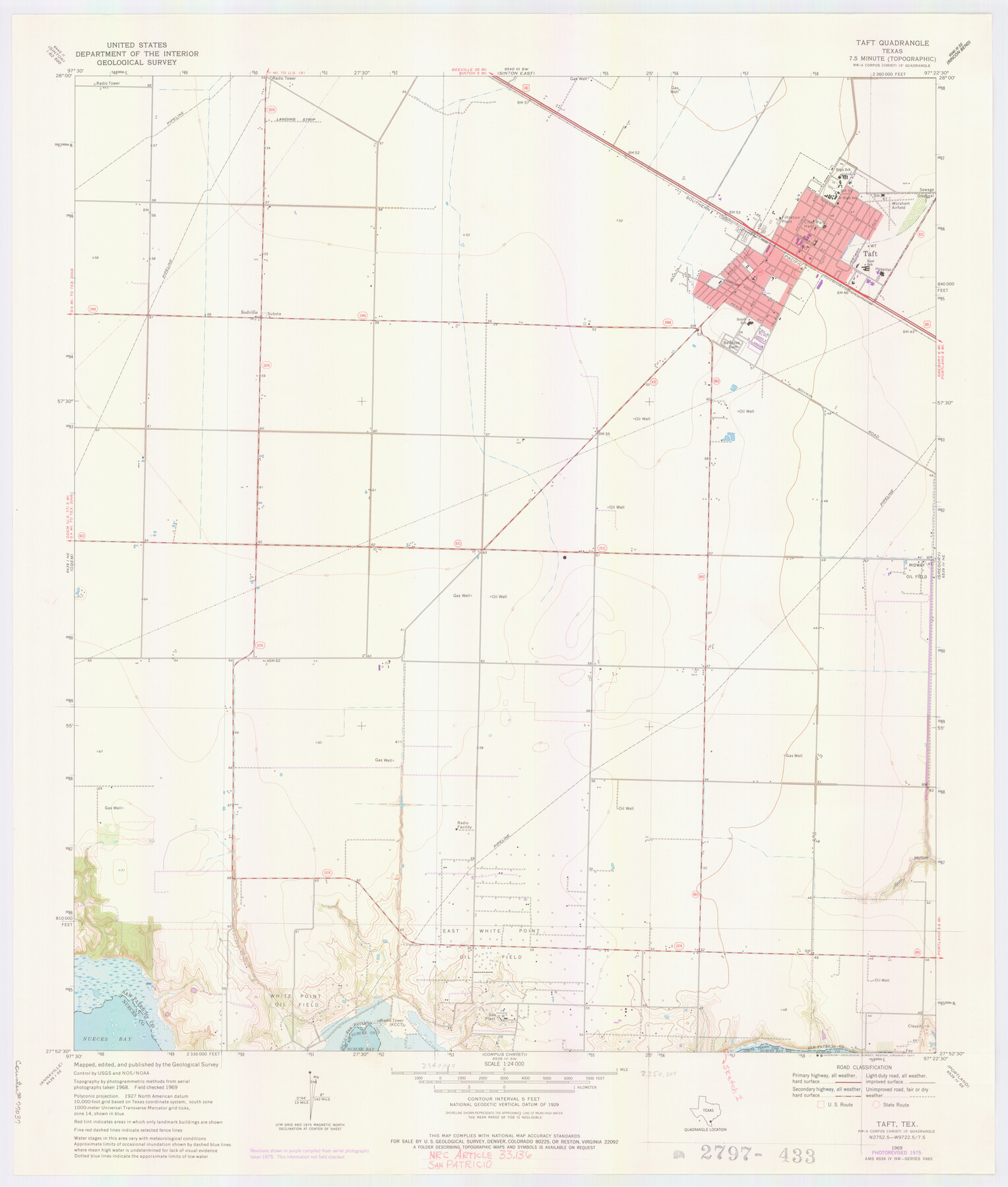
San Patricio County NRC Article 33.136 Location Key Sheet
Corpus Christi Quadrangle
-
Map/Doc
77037
-
Collection
General Map Collection
-
Object Dates
1975 (Creation Date)
-
People and Organizations
U. S. Geological Survey (Publisher)
U. S. Geological Survey (Printer)
-
Counties
San Patricio
-
Subjects
Surveying CBS
-
Height x Width
27.0 x 23.0 inches
68.6 x 58.4 cm
Part of: General Map Collection
Hudspeth County Rolled Sketch 28

Print $40.00
- Digital $50.00
Hudspeth County Rolled Sketch 28
Size 31.5 x 49.8 inches
Map/Doc 9208
Flight Mission No. DAG-28K, Frame 28, Matagorda County

Print $20.00
- Digital $50.00
Flight Mission No. DAG-28K, Frame 28, Matagorda County
1953
Size 18.5 x 22.5 inches
Map/Doc 86596
Cooke County Rolled Sketch 7

Print $20.00
- Digital $50.00
Cooke County Rolled Sketch 7
2002
Size 44.8 x 34.9 inches
Map/Doc 77525
Orange County Sketch File 17a

Print $4.00
- Digital $50.00
Orange County Sketch File 17a
Size 9.9 x 8.3 inches
Map/Doc 33342
[Surveys along the Nueces River, San Patricio District]
![69738, [Surveys along the Nueces River, San Patricio District], General Map Collection](https://historictexasmaps.com/wmedia_w700/maps/69738.tif.jpg)
Print $2.00
- Digital $50.00
[Surveys along the Nueces River, San Patricio District]
1842
Size 10.3 x 7.9 inches
Map/Doc 69738
United States - Gulf Coast Texas - Southern part of Laguna Madre

Print $20.00
- Digital $50.00
United States - Gulf Coast Texas - Southern part of Laguna Madre
1941
Size 18.2 x 27.7 inches
Map/Doc 72947
Motley County Working Sketch 2

Print $20.00
- Digital $50.00
Motley County Working Sketch 2
1895
Size 17.3 x 21.3 inches
Map/Doc 71207
Calhoun County Sketch File 11

Print $39.00
- Digital $50.00
Calhoun County Sketch File 11
1957
Size 11.4 x 8.9 inches
Map/Doc 35944
Henderson County Working Sketch 34

Print $20.00
- Digital $50.00
Henderson County Working Sketch 34
1965
Size 22.9 x 35.8 inches
Map/Doc 66167
Nueces County Sketch File 4

Print $4.00
- Digital $50.00
Nueces County Sketch File 4
1848
Size 10.1 x 8.0 inches
Map/Doc 32505
Flight Mission No. DQO-7K, Frame 84, Galveston County

Print $20.00
- Digital $50.00
Flight Mission No. DQO-7K, Frame 84, Galveston County
1952
Size 18.8 x 22.5 inches
Map/Doc 85111

You may also like
Van Zandt County

Print $20.00
- Digital $50.00
Van Zandt County
1857
Size 20.0 x 25.3 inches
Map/Doc 8144
Johnson County Working Sketch 11

Print $20.00
- Digital $50.00
Johnson County Working Sketch 11
1953
Size 28.7 x 22.4 inches
Map/Doc 66624
Flight Mission No. CGI-3N, Frame 77, Cameron County

Print $20.00
- Digital $50.00
Flight Mission No. CGI-3N, Frame 77, Cameron County
1954
Size 18.6 x 22.2 inches
Map/Doc 84571
Schleicher County Working Sketch 5

Print $20.00
- Digital $50.00
Schleicher County Working Sketch 5
1917
Size 23.0 x 17.6 inches
Map/Doc 63807
Uvalde County Rolled Sketch B

Print $20.00
- Digital $50.00
Uvalde County Rolled Sketch B
1847
Size 28.8 x 22.4 inches
Map/Doc 8105
"G" Sketch from Gaines County

Print $20.00
- Digital $50.00
"G" Sketch from Gaines County
1902
Size 31.7 x 21.7 inches
Map/Doc 90839
Caldwell County Working Sketch 5

Print $20.00
- Digital $50.00
Caldwell County Working Sketch 5
1940
Size 19.9 x 27.4 inches
Map/Doc 67835
La Salle County Rolled Sketch 34

Print $20.00
- Digital $50.00
La Salle County Rolled Sketch 34
2019
Size 22.3 x 35.5 inches
Map/Doc 95702
Cass County Working Sketch 26

Print $20.00
- Digital $50.00
Cass County Working Sketch 26
1974
Size 32.1 x 28.9 inches
Map/Doc 67929
Comal County Working Sketch 7

Print $20.00
- Digital $50.00
Comal County Working Sketch 7
1950
Size 42.1 x 31.8 inches
Map/Doc 68173
Deaf Smith County, Texas / [Sec. 144, Blk. K-5]
![92037, Deaf Smith County, Texas / [Sec. 144, Blk. K-5], Twichell Survey Records](https://historictexasmaps.com/wmedia_w700/maps/92037-1.tif.jpg)
Print $20.00
- Digital $50.00
Deaf Smith County, Texas / [Sec. 144, Blk. K-5]
Size 25.6 x 19.6 inches
Map/Doc 92037
