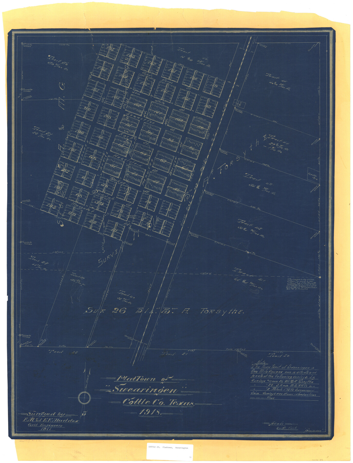
Plat Town of Swearingen, Cottle Co., Texas
-
Map/Doc
513
-
Collection
Maddox Collection
-
Object Dates
1918 (Creation Date)
1917 (Survey Date)
-
People and Organizations
F.M. Maddox (Surveyor/Engineer)
E.F. Maddox (Surveyor/Engineer)
-
Counties
Cottle
-
Height x Width
39.8 x 30.6 inches
101.1 x 77.7 cm
-
Medium
blueprint/diazo
-
Scale
200 feet = 1 inch
-
Features
QA&P
Margaret Street
Quanah Street
Decker Street
Paducah Street
Brewer Street
Hagelstein Street
Koch Street
Ledbetter Street
Lucile Street
Mulhall Street
Sam White Street
John Jones Street
Cemetery
Lazare Street
Part of: Maddox Collection
Spence Addition Owned by L.N. Goldbeck and Herman Pressler - A Subdivision of Outlot 43, Division "O"

Print $20.00
- Digital $50.00
Spence Addition Owned by L.N. Goldbeck and Herman Pressler - A Subdivision of Outlot 43, Division "O"
1913
Size 15.5 x 12.8 inches
Map/Doc 83424
Western portion of the Ward Ranch, Cottle, Foard & Hardeman Counties, Swearingen, Texas sold to Luther T. Clark

Print $20.00
- Digital $50.00
Western portion of the Ward Ranch, Cottle, Foard & Hardeman Counties, Swearingen, Texas sold to Luther T. Clark
1916
Size 30.4 x 30.7 inches
Map/Doc 4460
Sketch in Hardeman Co.

Print $3.00
- Digital $50.00
Sketch in Hardeman Co.
1890
Size 12.4 x 11.0 inches
Map/Doc 75925
[Working Sketch of a portion of Hidalgo & Starr Co's.]
![4447, [Working Sketch of a portion of Hidalgo & Starr Co's.], Maddox Collection](https://historictexasmaps.com/wmedia_w700/maps/4447.tif.jpg)
Print $20.00
- Digital $50.00
[Working Sketch of a portion of Hidalgo & Starr Co's.]
1906
Size 27.8 x 13.8 inches
Map/Doc 4447
[Sketch Showing Surveys in Dimmit County, Texas]
![75783, [Sketch Showing Surveys in Dimmit County, Texas], Maddox Collection](https://historictexasmaps.com/wmedia_w700/maps/75783.tif.jpg)
Print $20.00
- Digital $50.00
[Sketch Showing Surveys in Dimmit County, Texas]
Size 42.3 x 31.8 inches
Map/Doc 75783
[Surveying sketch of Dan'l. Dunham, O. de Santangelo, et al in Zavala County]
![708, [Surveying sketch of Dan'l. Dunham, O. de Santangelo, et al in Zavala County], Maddox Collection](https://historictexasmaps.com/wmedia_w700/maps/0708.tif.jpg)
Print $20.00
- Digital $50.00
[Surveying sketch of Dan'l. Dunham, O. de Santangelo, et al in Zavala County]
Size 16.2 x 16.0 inches
Map/Doc 708
Sketch of Dickens Co.

Print $20.00
- Digital $50.00
Sketch of Dickens Co.
1884
Size 17.6 x 14.5 inches
Map/Doc 75766
Tracing from a map of Swisher Subdivision of part of the Isaac Decker league southside Colorado River an addition to the City of Austin

Print $20.00
- Digital $50.00
Tracing from a map of Swisher Subdivision of part of the Isaac Decker league southside Colorado River an addition to the City of Austin
1877
Size 24.0 x 14.6 inches
Map/Doc 455
Map of Brazoria Co.

Print $20.00
- Digital $50.00
Map of Brazoria Co.
1879
Size 26.5 x 26.2 inches
Map/Doc 544
Baylor County, Texas

Print $20.00
- Digital $50.00
Baylor County, Texas
Size 21.7 x 18.9 inches
Map/Doc 525
Dawson County, Texas

Print $20.00
- Digital $50.00
Dawson County, Texas
1880
Size 28.6 x 20.5 inches
Map/Doc 705
[Skeleton Sketch of Unlabeled Surveys in Travis County, Texas]
![382, [Skeleton Sketch of Unlabeled Surveys in Travis County, Texas], Maddox Collection](https://historictexasmaps.com/wmedia_w700/maps/382.tif.jpg)
Print $20.00
- Digital $50.00
[Skeleton Sketch of Unlabeled Surveys in Travis County, Texas]
Size 28.9 x 36.8 inches
Map/Doc 382
You may also like
Bowie County Sketch File 6c

Print $40.00
- Digital $50.00
Bowie County Sketch File 6c
1927
Size 20.1 x 16.1 inches
Map/Doc 10942
Travis County Working Sketch 43

Print $20.00
- Digital $50.00
Travis County Working Sketch 43
1974
Size 24.1 x 24.6 inches
Map/Doc 69427
Pecos County Rolled Sketch 53

Print $20.00
- Digital $50.00
Pecos County Rolled Sketch 53
1915
Size 26.2 x 38.5 inches
Map/Doc 7228
Upshur County

Print $20.00
- Digital $50.00
Upshur County
1945
Size 37.7 x 33.5 inches
Map/Doc 77442
Map of Polk County

Print $20.00
- Digital $50.00
Map of Polk County
1879
Size 27.1 x 20.8 inches
Map/Doc 3959
Kinney County Working Sketch 55

Print $20.00
- Digital $50.00
Kinney County Working Sketch 55
1982
Size 25.1 x 24.7 inches
Map/Doc 70237
Marion County Rolled Sketch 9A

Print $20.00
- Digital $50.00
Marion County Rolled Sketch 9A
2001
Size 22.9 x 22.9 inches
Map/Doc 76419
Flight Mission No. DAG-21K, Frame 124, Matagorda County

Print $20.00
- Digital $50.00
Flight Mission No. DAG-21K, Frame 124, Matagorda County
1952
Size 18.5 x 22.4 inches
Map/Doc 86450
Clay County Sketch File 38

Print $4.00
- Digital $50.00
Clay County Sketch File 38
Size 16.4 x 25.0 inches
Map/Doc 11092
Rio Grande, Run Sheet

Print $2.00
- Digital $50.00
Rio Grande, Run Sheet
1931
Size 17.0 x 14.3 inches
Map/Doc 65120
Brewster County Rolled Sketch 14

Print $20.00
- Digital $50.00
Brewster County Rolled Sketch 14
1889
Size 31.5 x 27.3 inches
Map/Doc 8469
Flight Mission No. DAG-24K, Frame 150, Matagorda County

Print $20.00
- Digital $50.00
Flight Mission No. DAG-24K, Frame 150, Matagorda County
1953
Size 18.5 x 22.2 inches
Map/Doc 86564