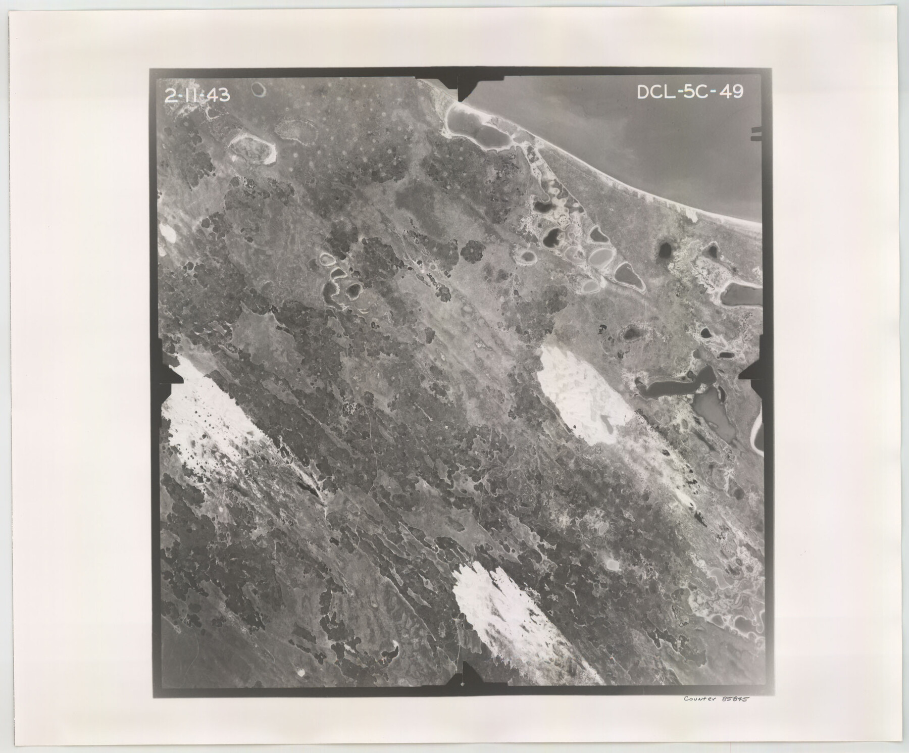
Flight Mission No. DCL-5C, Frame 49, Kenedy County
DCL-5C-49
-
Map/Doc
85845
-
Collection
General Map Collection
-
Object Dates
1943/2/11 (Creation Date)
-
People and Organizations
U. S. Department of Agriculture (Publisher)
-
Counties
Kenedy
-
Subjects
Aerial Photograph
-
Height x Width
18.5 x 22.3 inches
47.0 x 56.6 cm
-
Comments
Flown by Aerial Surveys of Pittsburgh, Inc. of Pittsburgh, Pennsylvania.
Part of: General Map Collection
Sterling County Rolled Sketch 29
![7854, Sterling County Rolled Sketch 29, General Map Collection](https://historictexasmaps.com/wmedia_w700/maps/7854.tif.jpg)
Print $20.00
- Digital $50.00
Sterling County Rolled Sketch 29
Size 30.0 x 23.5 inches
Map/Doc 7854
Field Notes of Surveys in Travis District (Callahan, Coleman, and Runnels Counties)
![81675, Field Notes of Surveys in Travis District (Callahan, Coleman, and Runnels Counties), General Map Collection](https://historictexasmaps.com/wmedia_w700/pdf_converted_jpg/qi_pdf_thumbnail_30438.jpg)
Field Notes of Surveys in Travis District (Callahan, Coleman, and Runnels Counties)
Map/Doc 81675
Presidio County Rolled Sketch 53
![7345, Presidio County Rolled Sketch 53, General Map Collection](https://historictexasmaps.com/wmedia_w700/maps/7345.tif.jpg)
Print $20.00
- Digital $50.00
Presidio County Rolled Sketch 53
1911
Size 14.3 x 21.7 inches
Map/Doc 7345
Blanco County Sketch File 36
![14642, Blanco County Sketch File 36, General Map Collection](https://historictexasmaps.com/wmedia_w700/pdf_converted_jpg/qi_pdf_thumbnail_9454.jpg)
Print $8.00
- Digital $50.00
Blanco County Sketch File 36
1889
Size 11.2 x 8.8 inches
Map/Doc 14642
Irion County Working Sketch 2
![66411, Irion County Working Sketch 2, General Map Collection](https://historictexasmaps.com/wmedia_w700/maps/66411.tif.jpg)
Print $20.00
- Digital $50.00
Irion County Working Sketch 2
Size 34.2 x 20.6 inches
Map/Doc 66411
Flight Mission No. DQN-2K, Frame 134, Calhoun County
![84303, Flight Mission No. DQN-2K, Frame 134, Calhoun County, General Map Collection](https://historictexasmaps.com/wmedia_w700/pdf_converted_jpg/qi_pdf_thumbnail_31521.jpg)
Print $20.00
- Digital $50.00
Flight Mission No. DQN-2K, Frame 134, Calhoun County
1953
Size 18.8 x 22.4 inches
Map/Doc 84303
Flight Mission No. BQR-22K, Frame 42, Brazoria County
![84126, Flight Mission No. BQR-22K, Frame 42, Brazoria County, General Map Collection](https://historictexasmaps.com/wmedia_w700/pdf_converted_jpg/qi_pdf_thumbnail_31343.jpg)
Print $20.00
- Digital $50.00
Flight Mission No. BQR-22K, Frame 42, Brazoria County
1953
Size 18.9 x 22.7 inches
Map/Doc 84126
Nueces County Rolled Sketch 10
![8350, Nueces County Rolled Sketch 10, General Map Collection](https://historictexasmaps.com/wmedia_w700/maps/8350.tif.jpg)
Print $40.00
- Digital $50.00
Nueces County Rolled Sketch 10
Size 55.4 x 31.6 inches
Map/Doc 8350
Travis County Sketch File 18
![12458, Travis County Sketch File 18, General Map Collection](https://historictexasmaps.com/wmedia_w700/pdf_converted_jpg/qi_pdf_thumbnail_8744.jpg)
Print $20.00
- Digital $50.00
Travis County Sketch File 18
1872
Size 24.2 x 25.4 inches
Map/Doc 12458
Floyd County Sketch File 17
![22747, Floyd County Sketch File 17, General Map Collection](https://historictexasmaps.com/wmedia_w700/pdf_converted_jpg/qi_pdf_thumbnail_11145.jpg)
Print $12.00
- Digital $50.00
Floyd County Sketch File 17
1913
Size 8.3 x 5.4 inches
Map/Doc 22747
Texas Intracoastal Waterway, Aransas Bay to Aransas Pass
![73438, Texas Intracoastal Waterway, Aransas Bay to Aransas Pass, General Map Collection](https://historictexasmaps.com/wmedia_w700/maps/73438-1.tif.jpg)
Print $20.00
- Digital $50.00
Texas Intracoastal Waterway, Aransas Bay to Aransas Pass
1962
Size 26.8 x 38.7 inches
Map/Doc 73438
Flight Mission No. CRC-3R, Frame 50, Chambers County
![84823, Flight Mission No. CRC-3R, Frame 50, Chambers County, General Map Collection](https://historictexasmaps.com/wmedia_w700/pdf_converted_jpg/qi_pdf_thumbnail_32038.jpg)
Print $20.00
- Digital $50.00
Flight Mission No. CRC-3R, Frame 50, Chambers County
1956
Size 18.7 x 22.3 inches
Map/Doc 84823
You may also like
Austin County Sketch File 18
![13927, Austin County Sketch File 18, General Map Collection](https://historictexasmaps.com/wmedia_w700/pdf_converted_jpg/qi_pdf_thumbnail_9216.jpg)
Print $14.00
- Digital $50.00
Austin County Sketch File 18
Size 12.8 x 8.2 inches
Map/Doc 13927
Wilson County Sketch File 12
![40425, Wilson County Sketch File 12, General Map Collection](https://historictexasmaps.com/wmedia_w700/pdf_converted_jpg/qi_pdf_thumbnail_15116.jpg)
Print $8.00
- Digital $50.00
Wilson County Sketch File 12
1841
Size 14.1 x 8.6 inches
Map/Doc 40425
Flight Mission No. CUG-3P, Frame 163, Kleberg County
![86283, Flight Mission No. CUG-3P, Frame 163, Kleberg County, General Map Collection](https://historictexasmaps.com/wmedia_w700/pdf_converted_jpg/qi_pdf_thumbnail_33427.jpg)
Print $20.00
- Digital $50.00
Flight Mission No. CUG-3P, Frame 163, Kleberg County
1956
Size 18.6 x 22.2 inches
Map/Doc 86283
Moore County Working Sketch 12
![71194, Moore County Working Sketch 12, General Map Collection](https://historictexasmaps.com/wmedia_w700/maps/71194.tif.jpg)
Print $20.00
- Digital $50.00
Moore County Working Sketch 12
Size 33.1 x 28.4 inches
Map/Doc 71194
Brewster County Working Sketch 43
![67577, Brewster County Working Sketch 43, General Map Collection](https://historictexasmaps.com/wmedia_w700/maps/67577.tif.jpg)
Print $20.00
- Digital $50.00
Brewster County Working Sketch 43
Size 33.7 x 36.2 inches
Map/Doc 67577
Travis County Working Sketch 15
![69399, Travis County Working Sketch 15, General Map Collection](https://historictexasmaps.com/wmedia_w700/maps/69399.tif.jpg)
Print $20.00
- Digital $50.00
Travis County Working Sketch 15
Size 16.1 x 19.7 inches
Map/Doc 69399
[Corpus Christi Bay, Padre Island, Mustang Island, Laguna de la Madre, King and Kenedy's Pasture]
![73043, [Corpus Christi Bay, Padre Island, Mustang Island, Laguna de la Madre, King and Kenedy's Pasture], General Map Collection](https://historictexasmaps.com/wmedia_w700/maps/73043.tif.jpg)
Print $20.00
- Digital $50.00
[Corpus Christi Bay, Padre Island, Mustang Island, Laguna de la Madre, King and Kenedy's Pasture]
Size 27.0 x 18.2 inches
Map/Doc 73043
PSL Field Notes for Blocks C36 and C37 in Gaines and Terry Counties, Block C38 in Dawson, Gaines, and Terry Counties, Blocks C39 and C41 in Dawson and Terry Counties, Block K in Yoakum and Terry Counties
![81674, PSL Field Notes for Blocks C36 and C37 in Gaines and Terry Counties, Block C38 in Dawson, Gaines, and Terry Counties, Blocks C39 and C41 in Dawson and Terry Counties, Block K in Yoakum and Terry Counties, General Map Collection](https://historictexasmaps.com/wmedia_w700/pdf_converted_jpg/qi_pdf_thumbnail_30437.jpg)
PSL Field Notes for Blocks C36 and C37 in Gaines and Terry Counties, Block C38 in Dawson, Gaines, and Terry Counties, Blocks C39 and C41 in Dawson and Terry Counties, Block K in Yoakum and Terry Counties
Map/Doc 81674
Hardin County Working Sketch 21
![63419, Hardin County Working Sketch 21, General Map Collection](https://historictexasmaps.com/wmedia_w700/maps/63419.tif.jpg)
Print $20.00
- Digital $50.00
Hardin County Working Sketch 21
Size 43.2 x 38.4 inches
Map/Doc 63419
Limestone County Sketch File 15
![30181, Limestone County Sketch File 15, General Map Collection](https://historictexasmaps.com/wmedia_w700/pdf_converted_jpg/qi_pdf_thumbnail_12749.jpg)
Print $8.00
- Digital $50.00
Limestone County Sketch File 15
1883
Size 12.7 x 8.0 inches
Map/Doc 30181
Morris County Working Sketch Graphic Index
![76649, Morris County Working Sketch Graphic Index, General Map Collection](https://historictexasmaps.com/wmedia_w700/maps/76649.tif.jpg)
Print $20.00
- Digital $50.00
Morris County Working Sketch Graphic Index
1948
Size 42.8 x 20.1 inches
Map/Doc 76649