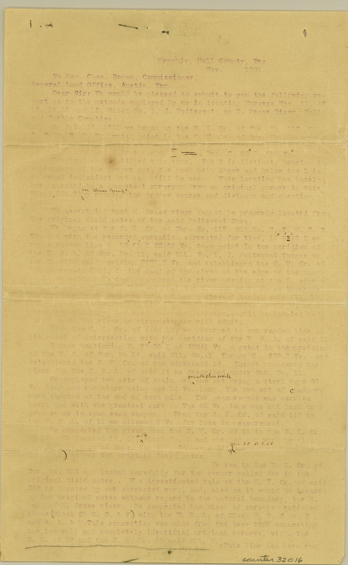
Motley County Sketch File 8 (N)
[Report on surveys along North Pease River]
- 
                          Map/Doc
32016
 - 
                            Collection
General Map Collection
 - 
                            Object Dates
11/1901 (Creation Date)
11/27/1901 (File Date)
11/1901 (Correspondence Date)
 - 
                            People and Organizations
W.J. Haggard (Surveyor/Engineer)
George H Chipman (Surveyor/Engineer)
 - 
                            Counties
Motley Cottle Hall
 - 
                            Subjects
Surveying Sketch File
 - 
                            Height x Width
13.2 x 8.1 inches
33.5 x 20.6 cm
 - 
                            Medium
paper, print
 - 
                            Features
North Pease River
 
Part of: General Map Collection
            Flight Mission No. DQN-5K, Frame 59, Calhoun County


                                            Print $20.00                    
                                             -                         Digital $50.00                                    
                Flight Mission No. DQN-5K, Frame 59, Calhoun County
1953
Size 18.7 x 22.3 inches
                                Map/Doc 84402
            
            Ector County Working Sketch 30


                                            Print $40.00                    
                                             -                         Digital $50.00                                    
                Ector County Working Sketch 30
1971
Size 43.2 x 64.1 inches
                                Map/Doc 68873
            
            Nacogdoches County Sketch File 15


                                            Print $10.00                    
                                             -                         Digital $50.00                                    
                Nacogdoches County Sketch File 15
1926
Size 11.2 x 8.7 inches
                                Map/Doc 32262
            
            Gregg County Rolled Sketch 20


                                            Print $20.00                    
                                             -                         Digital $50.00                                    
                Gregg County Rolled Sketch 20
1957
Size 34.6 x 44.7 inches
                                Map/Doc 6478
            
            Kenedy County Rolled Sketch 4


                                            Print $40.00                    
                                             -                         Digital $50.00                                    
                Kenedy County Rolled Sketch 4
1904
Size 39.4 x 57.6 inches
                                Map/Doc 10654
            
            Maps of Gulf Intracoastal Waterway, Texas - Sabine River to the Rio Grande and connecting waterways including ship channels


                                            Print $20.00                    
                                             -                         Digital $50.00                                    
                Maps of Gulf Intracoastal Waterway, Texas - Sabine River to the Rio Grande and connecting waterways including ship channels
1966
Size 14.5 x 22.3 inches
                                Map/Doc 61948
            
            Flight Mission No. DAG-23K, Frame 61, Matagorda County


                                            Print $20.00                    
                                             -                         Digital $50.00                                    
                Flight Mission No. DAG-23K, Frame 61, Matagorda County
1953
Size 16.0 x 15.7 inches
                                Map/Doc 86488
            
            Terrell County Working Sketch 72


                                            Print $20.00                    
                                             -                         Digital $50.00                                    
                Terrell County Working Sketch 72
1980
Size 14.3 x 24.8 inches
                                Map/Doc 69593
            
            Dimmit County Working Sketch 22


                                            Print $20.00                    
                                             -                         Digital $50.00                                    
                Dimmit County Working Sketch 22
1951
Size 37.3 x 38.7 inches
                                Map/Doc 68683
            
            Starr County Sketch File 22


                                            Print $20.00                    
                                             -                         Digital $50.00                                    
                Starr County Sketch File 22
1922
Size 16.4 x 35.9 inches
                                Map/Doc 12331
            
            El Paso County Boundary File 17


                                            Print $8.00                    
                                             -                         Digital $50.00                                    
                El Paso County Boundary File 17
Size 13.4 x 8.4 inches
                                Map/Doc 53192
            You may also like
            Flight Mission No. CGI-2N, Frame 179, Cameron County


                                            Print $20.00                    
                                             -                         Digital $50.00                                    
                Flight Mission No. CGI-2N, Frame 179, Cameron County
1954
Size 18.5 x 22.2 inches
                                Map/Doc 84539
            
            Val Verde County Rolled Sketch 38


                                            Print $20.00                    
                                             -                         Digital $50.00                                    
                Val Verde County Rolled Sketch 38
Size 30.4 x 19.5 inches
                                Map/Doc 61781
            
            Calhoun County Rolled Sketch 3


                                            Print $20.00                    
                                             -                         Digital $50.00                                    
                Calhoun County Rolled Sketch 3
Size 28.0 x 21.9 inches
                                Map/Doc 5361
            
            Runnels County Rolled Sketch 45


                                            Print $20.00                    
                                             -                         Digital $50.00                                    
                Runnels County Rolled Sketch 45
1954
Size 32.1 x 41.0 inches
                                Map/Doc 7532
            
            Sutton County Sketch File 42


                                            Print $6.00                    
                                             -                         Digital $50.00                                    
                Sutton County Sketch File 42
1940
Size 11.2 x 8.8 inches
                                Map/Doc 37509
            
            [Area to the West and North of the Abraham Winfrey survey 11]


                                            Print $20.00                    
                                             -                         Digital $50.00                                    
                [Area to the West and North of the Abraham Winfrey survey 11]
1920
Size 23.2 x 24.1 inches
                                Map/Doc 90228
            
            Galveston Bay Texas Lower Part Encluding [sic] Bar and Entrance


                                            Print $40.00                    
                                             -                         Digital $50.00                                    
                Galveston Bay Texas Lower Part Encluding [sic] Bar and Entrance
1867
Size 52.6 x 39.1 inches
                                Map/Doc 69869
            
            Caldwell County Working Sketch 7


                                            Print $20.00                    
                                             -                         Digital $50.00                                    
                Caldwell County Working Sketch 7
1958
Size 29.7 x 37.2 inches
                                Map/Doc 67837
            
            Guadalupe County Working Sketch 1 and 1b


                                            Print $20.00                    
                                             -                         Digital $50.00                                    
                Guadalupe County Working Sketch 1 and 1b
1924
Size 16.3 x 32.5 inches
                                Map/Doc 63310
            
            Freestone County Sketch File 22


                                            Print $40.00                    
                                             -                         Digital $50.00                                    
                Freestone County Sketch File 22
1886
Size 14.4 x 17.3 inches
                                Map/Doc 23082
            
            Topographical Map of the country between San Antonio & Colorado Rivers in the State of Texas.


                                            Print $40.00                    
                                    
                Topographical Map of the country between San Antonio & Colorado Rivers in the State of Texas.
1864
Size 53.2 x 74.8 inches
                                Map/Doc 88606
            
            General Highway Map, Lamb County, Texas


                                            Print $20.00                    
                                    
                General Highway Map, Lamb County, Texas
1961
Size 24.5 x 18.2 inches
                                Map/Doc 79562