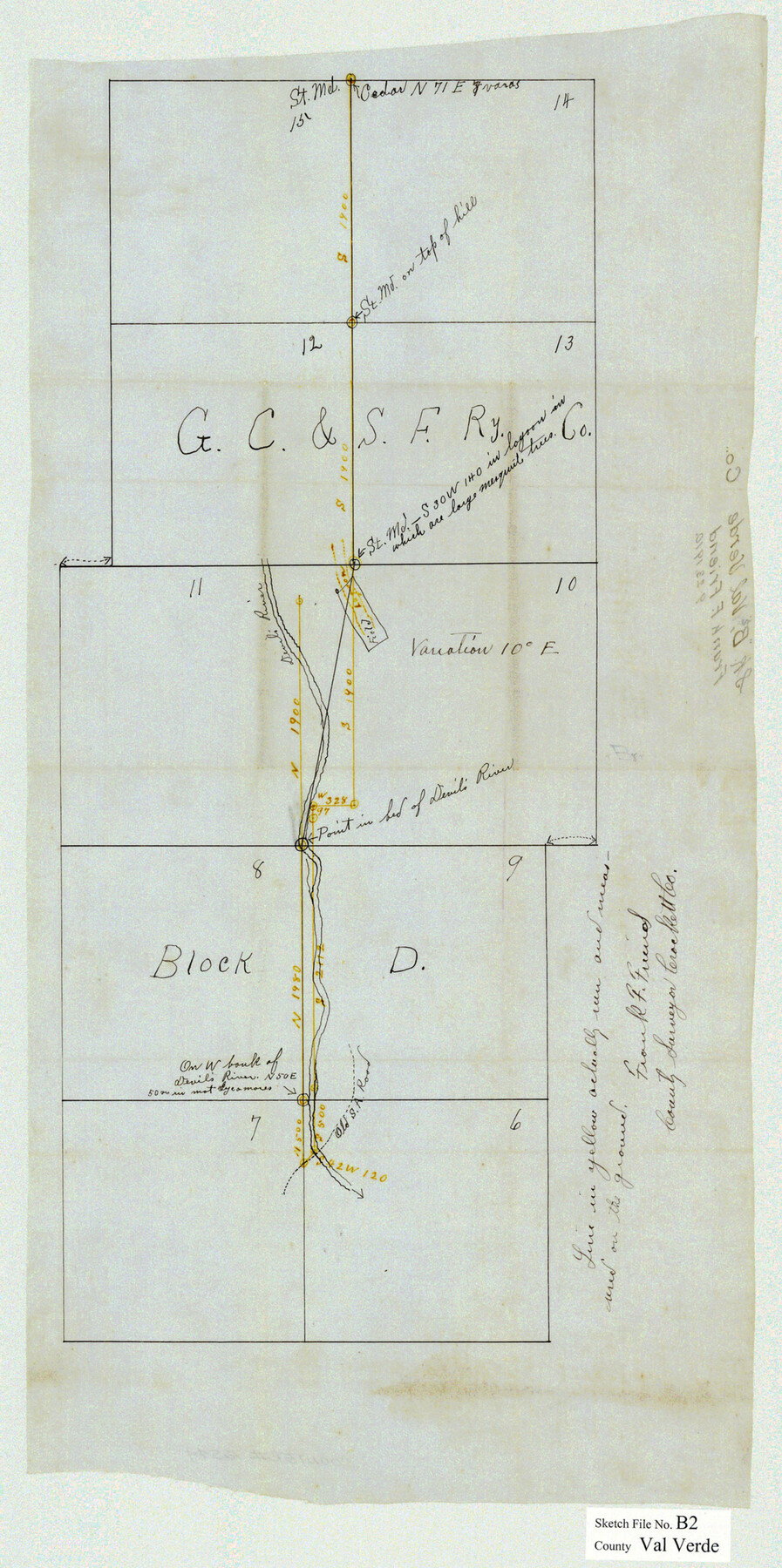
Val Verde County Sketch File B2
[Sketch of surveys in G. C. & S. F. Ry. Co. Block D]
-
Map/Doc
12544
-
Collection
General Map Collection
-
Object Dates
9/23/1910 (Creation Date)
-
People and Organizations
Frank F. Friend (Surveyor/Engineer)
-
Counties
Val Verde
-
Subjects
Surveying Sketch File
-
Height x Width
24.5 x 12.2 inches
62.2 x 31.0 cm
-
Medium
paper, manuscript
-
Features
Devil's River
Old San Antonio Road
Part of: General Map Collection
International boundary between U.S. & Mexico in Gulf of Mexico from 12 mile point easterly to 200 mile limit

Print $3.00
- Digital $50.00
International boundary between U.S. & Mexico in Gulf of Mexico from 12 mile point easterly to 200 mile limit
1976
Size 9.6 x 14.8 inches
Map/Doc 1748
[Miller Day Ranch]
![81517, [Miller Day Ranch], General Map Collection](https://historictexasmaps.com/wmedia_w700/maps/81517.tif.jpg)
Print $40.00
- Digital $50.00
[Miller Day Ranch]
1995
Size 60.6 x 38.0 inches
Map/Doc 81517
Ellis County Boundary File 5

Print $4.00
- Digital $50.00
Ellis County Boundary File 5
Size 11.5 x 7.2 inches
Map/Doc 52990
Map of Giddings

Print $20.00
- Digital $50.00
Map of Giddings
1940
Size 16.5 x 21.2 inches
Map/Doc 2210
Sutton County Rolled Sketch 55

Print $40.00
- Digital $50.00
Sutton County Rolled Sketch 55
1954
Size 59.9 x 39.9 inches
Map/Doc 9976
Glasscock County Sketch File 5

Print $20.00
- Digital $50.00
Glasscock County Sketch File 5
1929
Size 23.0 x 22.7 inches
Map/Doc 11561
Intracoastal Waterway in Texas - Corpus Christi to Point Isabel including Arroyo Colorado to Mo. Pac. R.R. Bridge Near Harlingen

Print $20.00
- Digital $50.00
Intracoastal Waterway in Texas - Corpus Christi to Point Isabel including Arroyo Colorado to Mo. Pac. R.R. Bridge Near Harlingen
1933
Size 28.1 x 41.2 inches
Map/Doc 61845
Flight Mission No. CRC-5R, Frame 19, Chambers County

Print $20.00
- Digital $50.00
Flight Mission No. CRC-5R, Frame 19, Chambers County
1956
Size 18.8 x 22.4 inches
Map/Doc 84941
Harris County Historic Topographic 12

Print $20.00
- Digital $50.00
Harris County Historic Topographic 12
1915
Size 19.5 x 23.5 inches
Map/Doc 65822
Presidio County Working Sketch 122

Print $20.00
- Digital $50.00
Presidio County Working Sketch 122
1984
Size 42.6 x 45.6 inches
Map/Doc 71800
Eastland County Working Sketch 32

Print $20.00
- Digital $50.00
Eastland County Working Sketch 32
1956
Size 23.0 x 16.9 inches
Map/Doc 68813
Motley County Sketch File 16 (N)

Print $16.00
- Digital $50.00
Motley County Sketch File 16 (N)
1911
Size 11.0 x 8.6 inches
Map/Doc 32052
You may also like
Outer Continental Shelf Leasing Maps (Louisiana Offshore Operations)

Print $20.00
- Digital $50.00
Outer Continental Shelf Leasing Maps (Louisiana Offshore Operations)
1959
Size 17.8 x 14.1 inches
Map/Doc 76095
Starr County Working Sketch 12

Print $20.00
- Digital $50.00
Starr County Working Sketch 12
1949
Size 43.2 x 25.5 inches
Map/Doc 63928
[Blocks S2, K3, K, and S1]
![90415, [Blocks S2, K3, K, and S1], Twichell Survey Records](https://historictexasmaps.com/wmedia_w700/maps/90415-1.tif.jpg)
Print $20.00
- Digital $50.00
[Blocks S2, K3, K, and S1]
1906
Size 17.9 x 16.4 inches
Map/Doc 90415
Hudspeth County Rolled Sketch 53

Print $77.00
- Digital $50.00
Hudspeth County Rolled Sketch 53
1977
Size 9.9 x 15.1 inches
Map/Doc 45849
Flight Mission No. DQO-8K, Frame 41, Galveston County

Print $20.00
- Digital $50.00
Flight Mission No. DQO-8K, Frame 41, Galveston County
1952
Size 18.7 x 22.3 inches
Map/Doc 85148
Lamar County Sketch File 13

Print $2.00
- Digital $50.00
Lamar County Sketch File 13
1943
Size 10.9 x 8.0 inches
Map/Doc 29307

Jim Hogg County Rolled Sketch EJF

Print $20.00
- Digital $50.00
Jim Hogg County Rolled Sketch EJF
1937
Size 36.0 x 32.4 inches
Map/Doc 9320
Newton County Working Sketch 22

Print $20.00
- Digital $50.00
Newton County Working Sketch 22
1952
Size 25.3 x 43.2 inches
Map/Doc 71268
McMullen County Rolled Sketch 5

Print $20.00
- Digital $50.00
McMullen County Rolled Sketch 5
Size 46.4 x 26.8 inches
Map/Doc 6723
Crockett County Sketch File 96

Print $4.00
- Digital $50.00
Crockett County Sketch File 96
1934
Size 11.4 x 8.9 inches
Map/Doc 19964
Neel's Creek of North Bosque

Print $2.00
- Digital $50.00
Neel's Creek of North Bosque
1847
Size 8.9 x 7.9 inches
Map/Doc 69755