Sterling County Sketch File 13
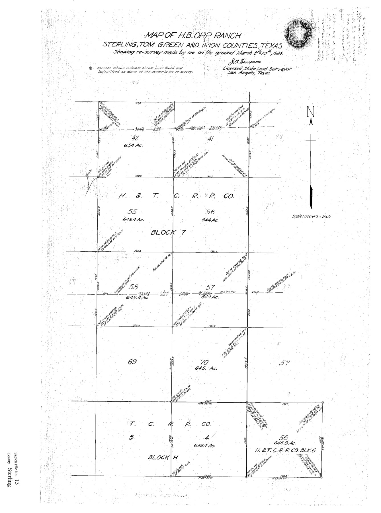
Map of H. B. Opp Ranch, Sterling, Tom Green & Irion Counties, Texas
-
Map/Doc
12359
-
Collection
General Map Collection
-
Object Dates
1934/3/24 (File Date)
1934/3/10 (Survey Date)
-
People and Organizations
J.A. Simpson (Surveyor/Engineer)
-
Counties
Sterling
-
Subjects
Surveying Sketch File
-
Height x Width
26.1 x 19.4 inches
66.3 x 49.3 cm
-
Medium
paper, print
-
Scale
1:500
Part of: General Map Collection
Glasscock County Sketch File 19

Print $20.00
- Digital $50.00
Glasscock County Sketch File 19
Size 21.4 x 16.8 inches
Map/Doc 11563
Flight Mission No. DQO-3K, Frame 81, Galveston County

Print $20.00
- Digital $50.00
Flight Mission No. DQO-3K, Frame 81, Galveston County
1952
Size 18.7 x 22.5 inches
Map/Doc 85086
Nueces County Rolled Sketch 63

Print $20.00
- Digital $50.00
Nueces County Rolled Sketch 63
1979
Size 25.5 x 38.1 inches
Map/Doc 6909
Flight Mission No. CGI-1N, Frame 183, Cameron County

Print $20.00
- Digital $50.00
Flight Mission No. CGI-1N, Frame 183, Cameron County
1955
Size 18.8 x 22.2 inches
Map/Doc 84518
Flight Mission No. DQO-1K, Frame 149, Galveston County

Print $20.00
- Digital $50.00
Flight Mission No. DQO-1K, Frame 149, Galveston County
1952
Size 19.0 x 22.8 inches
Map/Doc 85002
United States Great Lakes and adjacent waterways

Print $20.00
- Digital $50.00
United States Great Lakes and adjacent waterways
Size 20.8 x 42.2 inches
Map/Doc 76121
Upper Galveston Bay, Houston Ship Channel, Dollar Pt. to Atkinson I.

Print $40.00
- Digital $50.00
Upper Galveston Bay, Houston Ship Channel, Dollar Pt. to Atkinson I.
1976
Size 49.3 x 36.5 inches
Map/Doc 69897
Brazos County Working Sketch 6

Print $20.00
- Digital $50.00
Brazos County Working Sketch 6
1979
Size 29.4 x 20.5 inches
Map/Doc 67481
San Saba County Sketch File 14a

Print $14.00
- Digital $50.00
San Saba County Sketch File 14a
1891
Size 14.5 x 8.8 inches
Map/Doc 36441
Jefferson Co.

Print $40.00
- Digital $50.00
Jefferson Co.
1978
Size 48.2 x 42.7 inches
Map/Doc 73196
Cameron County

Print $20.00
- Digital $50.00
Cameron County
1976
Size 30.9 x 38.1 inches
Map/Doc 77230
Haskell County

Print $20.00
- Digital $50.00
Haskell County
1933
Size 44.9 x 37.9 inches
Map/Doc 73175
You may also like
W. D. Twichell's Preliminary Report Showing R. S. Hunnicutt's Reconnoissance Survey in Parmer County, Texas November 6th to 19th, 1915

Print $20.00
- Digital $50.00
W. D. Twichell's Preliminary Report Showing R. S. Hunnicutt's Reconnoissance Survey in Parmer County, Texas November 6th to 19th, 1915
1915
Size 45.1 x 42.8 inches
Map/Doc 89803
Flight Mission No. CUG-3P, Frame 79, Kleberg County

Print $20.00
- Digital $50.00
Flight Mission No. CUG-3P, Frame 79, Kleberg County
1956
Size 18.4 x 22.2 inches
Map/Doc 86254
Calhoun County Rolled Sketch 28A

Print $20.00
- Digital $50.00
Calhoun County Rolled Sketch 28A
1834
Size 23.1 x 33.1 inches
Map/Doc 5375
Nolan County Working Sketch 1

Print $20.00
- Digital $50.00
Nolan County Working Sketch 1
1928
Size 17.9 x 17.5 inches
Map/Doc 71292
Railroad Track Map, H&TCRRCo., Falls County, Texas

Print $4.00
- Digital $50.00
Railroad Track Map, H&TCRRCo., Falls County, Texas
1918
Size 11.4 x 18.5 inches
Map/Doc 62859
Sketch Showing Original Corners Affecting Block I and Adjacent Surveys from Actual Connections by W. D. Twichell

Print $20.00
- Digital $50.00
Sketch Showing Original Corners Affecting Block I and Adjacent Surveys from Actual Connections by W. D. Twichell
Size 23.6 x 24.5 inches
Map/Doc 90156
Crane County Working Sketch 18

Print $20.00
- Digital $50.00
Crane County Working Sketch 18
1959
Size 37.9 x 18.8 inches
Map/Doc 68295
Howard County Sketch File 12

Print $20.00
- Digital $50.00
Howard County Sketch File 12
1939
Size 18.2 x 15.7 inches
Map/Doc 11799
Marion County Working Sketch 33

Print $20.00
- Digital $50.00
Marion County Working Sketch 33
1983
Size 16.0 x 20.7 inches
Map/Doc 70809
Sketch showing connections made in survey of the Jerry Barton preemption

Print $20.00
- Digital $50.00
Sketch showing connections made in survey of the Jerry Barton preemption
1892
Size 18.5 x 23.6 inches
Map/Doc 75558
Southern Part of Laguna Madre

Print $20.00
- Digital $50.00
Southern Part of Laguna Madre
1981
Size 45.1 x 35.8 inches
Map/Doc 73546
