Houston Ship Channel, Alexander Island to Carpenter Bayou
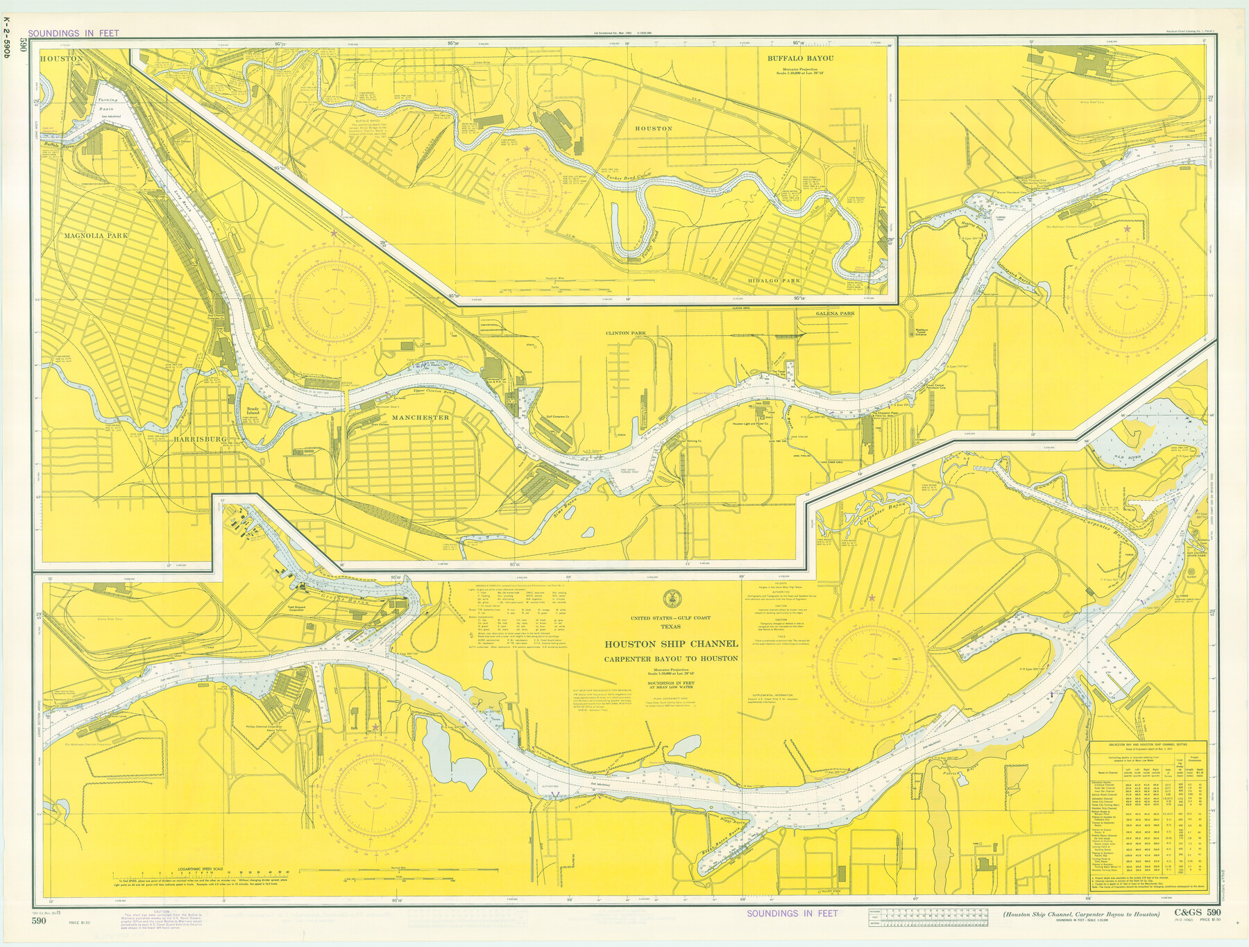
Houston Ship Channel, Carpenter Bayou to Houston
K-2-589; K-2-590
-
Map/Doc
69908
-
Collection
General Map Collection
-
Object Dates
1971/11/20 (Creation Date)
-
Counties
Harris
-
Subjects
Nautical Charts
-
Height x Width
34.9 x 46.0 inches
88.6 x 116.8 cm
-
Comments
dual-sided map
Part of: General Map Collection
Texas Coast, No. 17

Print $20.00
- Digital $50.00
Texas Coast, No. 17
Size 18.3 x 26.1 inches
Map/Doc 72713
Grayson County Working Sketch 19

Print $20.00
- Digital $50.00
Grayson County Working Sketch 19
1956
Size 40.0 x 29.0 inches
Map/Doc 63258
Real County Working Sketch 45

Print $20.00
- Digital $50.00
Real County Working Sketch 45
1955
Size 23.1 x 18.5 inches
Map/Doc 71937
McCulloch County Rolled Sketch 6

Print $20.00
- Digital $50.00
McCulloch County Rolled Sketch 6
1982
Size 27.9 x 33.9 inches
Map/Doc 6717
Van Zandt County Sketch File 36

Print $4.00
- Digital $50.00
Van Zandt County Sketch File 36
1864
Size 8.0 x 10.4 inches
Map/Doc 39478
Garza County Working Sketch 11

Print $3.00
- Digital $50.00
Garza County Working Sketch 11
1955
Size 14.5 x 10.9 inches
Map/Doc 63158
Map of Anderson County

Print $20.00
- Digital $50.00
Map of Anderson County
1876
Size 19.4 x 21.9 inches
Map/Doc 3228
Anderson County Sketch File 11

Print $6.00
- Digital $50.00
Anderson County Sketch File 11
1853
Size 8.7 x 6.6 inches
Map/Doc 12765

Flight Mission No. DQO-3K, Frame 34, Galveston County

Print $20.00
- Digital $50.00
Flight Mission No. DQO-3K, Frame 34, Galveston County
1952
Size 18.7 x 22.4 inches
Map/Doc 85075
Travis County Working Sketch 7

Print $2.00
- Digital $50.00
Travis County Working Sketch 7
1913
Size 10.9 x 8.2 inches
Map/Doc 69391
Crockett County Sketch File 12

Print $20.00
- Digital $50.00
Crockett County Sketch File 12
Size 26.8 x 18.9 inches
Map/Doc 11216
You may also like
Reeves County Working Sketch 40

Print $40.00
- Digital $50.00
Reeves County Working Sketch 40
1973
Size 66.0 x 39.2 inches
Map/Doc 63483
Terrell County Rolled Sketch 40

Print $20.00
- Digital $50.00
Terrell County Rolled Sketch 40
1943
Size 16.7 x 18.1 inches
Map/Doc 7944
Geographical, Statistical, and Historical Map of Arkansas Territory

Print $20.00
- Digital $50.00
Geographical, Statistical, and Historical Map of Arkansas Territory
Size 17.9 x 21.9 inches
Map/Doc 95713
C. D. Collard's Lines

Print $20.00
- Digital $50.00
C. D. Collard's Lines
Size 44.1 x 47.0 inches
Map/Doc 90704
Chambers County Rolled Sketch 30

Print $20.00
- Digital $50.00
Chambers County Rolled Sketch 30
1952
Size 26.7 x 37.9 inches
Map/Doc 5430
Hopkins County Sketch File 16

Print $4.00
- Digital $50.00
Hopkins County Sketch File 16
1870
Size 8.1 x 10.1 inches
Map/Doc 26713
Presidio County Rolled Sketch 98

Print $20.00
- Digital $50.00
Presidio County Rolled Sketch 98
Size 22.5 x 24.5 inches
Map/Doc 7381
Map of Texas shewing the grants in possession of the Colorado & Red River Land Compy

Print $20.00
- Digital $50.00
Map of Texas shewing the grants in possession of the Colorado & Red River Land Compy
1835
Size 20.3 x 26.9 inches
Map/Doc 93850
Webb County Sketch File B2

Print $4.00
- Digital $50.00
Webb County Sketch File B2
1909
Size 13.9 x 8.1 inches
Map/Doc 39656
Flight Mission No. DIX-3P, Frame 171, Aransas County

Print $20.00
- Digital $50.00
Flight Mission No. DIX-3P, Frame 171, Aransas County
1956
Size 17.6 x 18.2 inches
Map/Doc 83777
Kimble County Sketch File 11

Print $40.00
- Digital $50.00
Kimble County Sketch File 11
1882
Size 20.5 x 10.2 inches
Map/Doc 28933
General Highway Map, Medina County, Texas

Print $20.00
General Highway Map, Medina County, Texas
1961
Size 18.2 x 25.0 inches
Map/Doc 79594