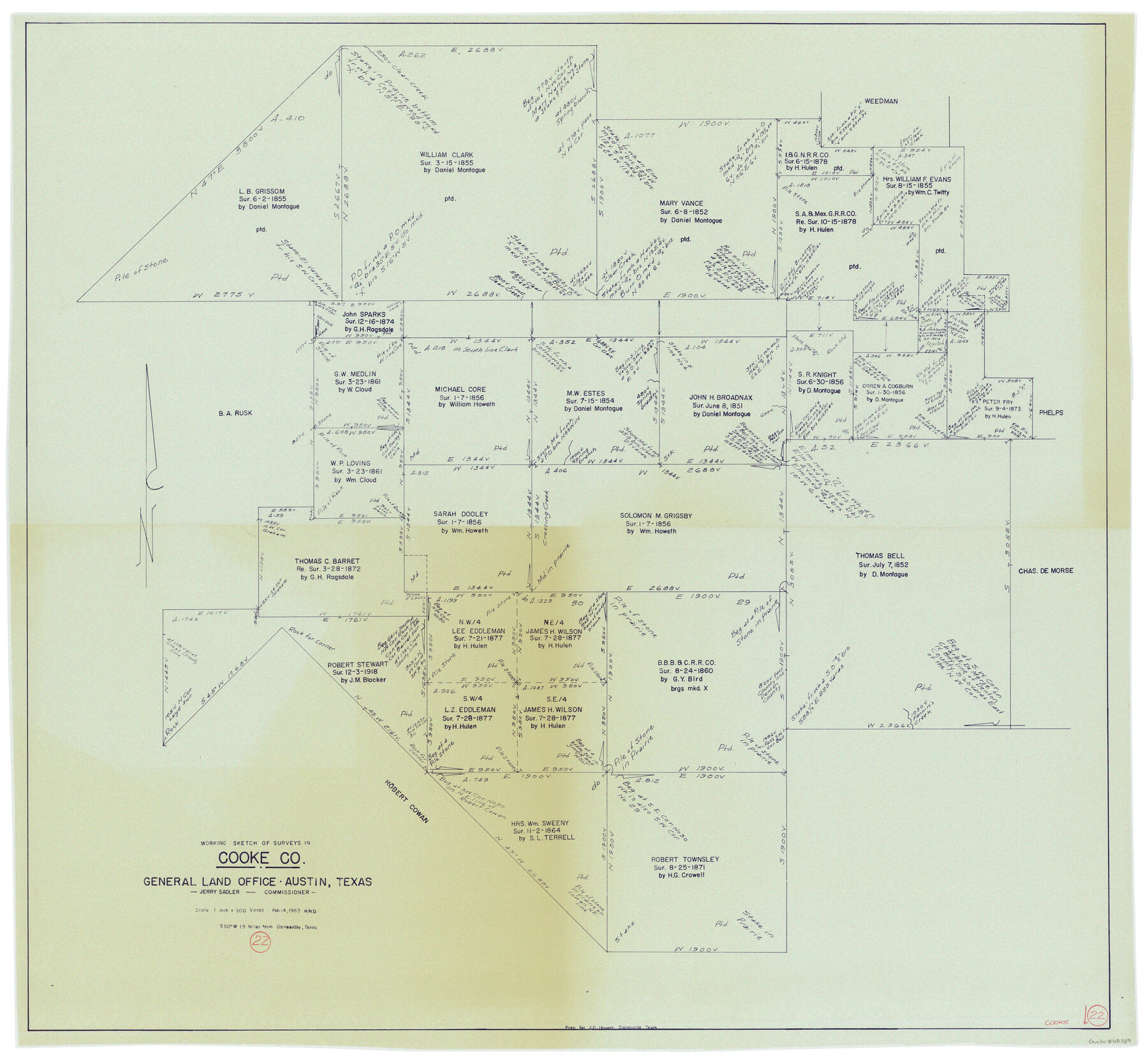
Cooke County Working Sketch 22
-
Map/Doc
68259
-
Collection
General Map Collection
-
Object Dates
2/14/1963 (Creation Date)
-
People and Organizations
Herbert H. Ulbricht (Draftsman)
-
Counties
Cooke
-
Subjects
Surveying Working Sketch
-
Height x Width
37.0 x 40.2 inches
94.0 x 102.1 cm
-
Scale
1" = 300 varas
Part of: General Map Collection
Haskell County Rolled Sketch 15A

Print $3.00
- Digital $50.00
Haskell County Rolled Sketch 15A
1991
Size 11.3 x 17.1 inches
Map/Doc 6174
Martin County

Print $20.00
- Digital $50.00
Martin County
1933
Size 38.9 x 34.0 inches
Map/Doc 77366
Ward County Working Sketch 53

Print $40.00
- Digital $50.00
Ward County Working Sketch 53
1982
Size 37.0 x 53.4 inches
Map/Doc 72359
Clay County Sketch File 26

Print $84.00
- Digital $50.00
Clay County Sketch File 26
1888
Size 14.3 x 9.0 inches
Map/Doc 18442
Chambers County Sketch File 11

Print $40.00
- Digital $50.00
Chambers County Sketch File 11
Size 13.7 x 12.6 inches
Map/Doc 17554
Galveston County NRC Article 33.136 Sketch 55

Print $78.00
- Digital $50.00
Galveston County NRC Article 33.136 Sketch 55
2009
Size 23.0 x 34.3 inches
Map/Doc 94580
Zavala County Working Sketch 24

Print $40.00
- Digital $50.00
Zavala County Working Sketch 24
1980
Size 75.6 x 42.8 inches
Map/Doc 62099
Real County Rolled Sketch 6

Print $20.00
- Digital $50.00
Real County Rolled Sketch 6
Size 28.0 x 23.7 inches
Map/Doc 7456
Ward County Working Sketch 12

Print $20.00
- Digital $50.00
Ward County Working Sketch 12
1947
Size 23.4 x 22.7 inches
Map/Doc 72318
Brewster County Rolled Sketch 101

Print $40.00
- Digital $50.00
Brewster County Rolled Sketch 101
1927
Size 55.0 x 40.0 inches
Map/Doc 8509
Mason County Working Sketch 10

Print $40.00
- Digital $50.00
Mason County Working Sketch 10
1949
Size 42.4 x 49.7 inches
Map/Doc 70846
Webb County Rolled Sketch 77

Print $20.00
- Digital $50.00
Webb County Rolled Sketch 77
1980
Size 39.1 x 38.5 inches
Map/Doc 10134
You may also like
West Houston: Hwy. 6 from Spencer Rd. in the North to South of Sugar Land. From Wilcrest Dr. in the East to and including Katy.

West Houston: Hwy. 6 from Spencer Rd. in the North to South of Sugar Land. From Wilcrest Dr. in the East to and including Katy.
Size 35.4 x 22.7 inches
Map/Doc 94336
Sketch in Southeast Portion of Stephens County, Texas showing various lines and corners as found upon survey

Print $20.00
- Digital $50.00
Sketch in Southeast Portion of Stephens County, Texas showing various lines and corners as found upon survey
1919
Size 19.2 x 34.3 inches
Map/Doc 91842
Presidio County Rolled Sketch 121

Print $40.00
- Digital $50.00
Presidio County Rolled Sketch 121
1939
Size 50.4 x 43.1 inches
Map/Doc 9797
General Highway Map Cochran County, Texas

Print $20.00
- Digital $50.00
General Highway Map Cochran County, Texas
1948
Size 18.7 x 25.6 inches
Map/Doc 92498
El Paso County Working Sketch 36

Print $20.00
- Digital $50.00
El Paso County Working Sketch 36
1983
Size 34.0 x 40.3 inches
Map/Doc 69058
[T. & P. Blocks 33 and 34, Township 5N]
![90561, [T. & P. Blocks 33 and 34, Township 5N], Twichell Survey Records](https://historictexasmaps.com/wmedia_w700/maps/90561-1.tif.jpg)
Print $20.00
- Digital $50.00
[T. & P. Blocks 33 and 34, Township 5N]
Size 26.0 x 18.4 inches
Map/Doc 90561
Ward County Working Sketch 54

Print $40.00
- Digital $50.00
Ward County Working Sketch 54
1978
Size 24.1 x 48.8 inches
Map/Doc 72360
Right of Way and Track Map Houston & Texas Central R.R. operated by the T. and N. O. R.R. Co., Fort Worth Branch

Print $40.00
- Digital $50.00
Right of Way and Track Map Houston & Texas Central R.R. operated by the T. and N. O. R.R. Co., Fort Worth Branch
1918
Size 30.7 x 56.4 inches
Map/Doc 64542
Webb County Sketch File 8a

Print $4.00
- Digital $50.00
Webb County Sketch File 8a
Size 7.9 x 8.7 inches
Map/Doc 39743
Plano General de la Ciudad de Mexico. Levantado Por el Teniente Coronel Don Diego Garcia Conde en el Año de 1793. Aumentado y corregido en lo mas notable Por el Teniente Coronel retirado, Don Rafael Maria Calvo En el de 1830

Print $20.00
- Digital $50.00
Plano General de la Ciudad de Mexico. Levantado Por el Teniente Coronel Don Diego Garcia Conde en el Año de 1793. Aumentado y corregido en lo mas notable Por el Teniente Coronel retirado, Don Rafael Maria Calvo En el de 1830
1793
Size 19.7 x 21.8 inches
Map/Doc 95354
Flight Mission No. CRC-4R, Frame 107, Chambers County

Print $20.00
- Digital $50.00
Flight Mission No. CRC-4R, Frame 107, Chambers County
1956
Size 18.8 x 22.4 inches
Map/Doc 84904
Blanco County Rolled Sketch 11

Print $6.00
- Digital $50.00
Blanco County Rolled Sketch 11
Size 33.2 x 27.8 inches
Map/Doc 5147