McMullen County Sketch File 37
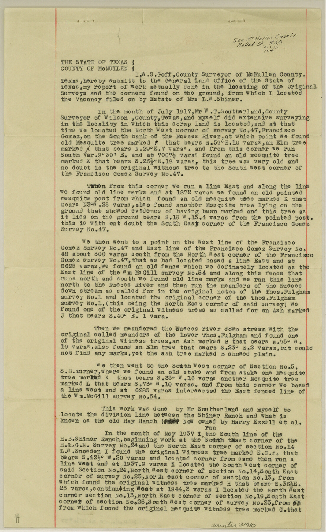
[Report of work done locating vacancy filed on by Estate of Mrs. L. W. Shiner]
-
Map/Doc
31410
-
Collection
General Map Collection
-
Object Dates
1937/9/10 (Creation Date)
1937/12/6 (File Date)
1917 (Survey Date)
1937 (Survey Date)
-
People and Organizations
W.S. Goff (Surveyor/Engineer)
W.T. Southerland (Surveyor/Engineer)
-
Counties
McMullen Wilson
-
Subjects
Surveying Sketch File
-
Height x Width
14.3 x 8.8 inches
36.3 x 22.4 cm
-
Medium
paper, print
-
Features
Road from Tilden to San Diego
Cow Creek
Nueces River
H.B. Shiner Ranch
Old Ray Ranch
Part of: General Map Collection
Flight Mission No. CGI-1N, Frame 141, Cameron County

Print $20.00
- Digital $50.00
Flight Mission No. CGI-1N, Frame 141, Cameron County
1955
Size 18.5 x 22.2 inches
Map/Doc 84497
Portion of States Submerged Area in Matagorda Bay

Print $20.00
- Digital $50.00
Portion of States Submerged Area in Matagorda Bay
1919
Size 16.8 x 17.2 inches
Map/Doc 2949
Edwards County Working Sketch 105

Print $40.00
- Digital $50.00
Edwards County Working Sketch 105
1972
Size 55.3 x 34.2 inches
Map/Doc 68981
Brazos County Rolled Sketch 6

Print $20.00
- Digital $50.00
Brazos County Rolled Sketch 6
1979
Size 24.3 x 36.4 inches
Map/Doc 5190
Galveston County Aerial Photograph Index Sheet 2

Print $20.00
- Digital $50.00
Galveston County Aerial Photograph Index Sheet 2
1953
Size 21.2 x 19.5 inches
Map/Doc 83693
Corrected Map of T&P Ry. surveys in counties Pecos-Presidio-El Paso

Print $20.00
- Digital $50.00
Corrected Map of T&P Ry. surveys in counties Pecos-Presidio-El Paso
1884
Size 27.9 x 39.0 inches
Map/Doc 2301
Flight Mission No. BRA-8M, Frame 22, Jefferson County

Print $20.00
- Digital $50.00
Flight Mission No. BRA-8M, Frame 22, Jefferson County
1953
Size 18.5 x 22.4 inches
Map/Doc 85577
Fisher County

Print $40.00
- Digital $50.00
Fisher County
1944
Size 48.4 x 42.5 inches
Map/Doc 73147
Territorios de Sierragorda e Isla del Carmen

Print $20.00
- Digital $50.00
Territorios de Sierragorda e Isla del Carmen
Size 22.9 x 31.2 inches
Map/Doc 97011
Galveston County NRC Article 33.136 Location Key Sheet

Print $20.00
- Digital $50.00
Galveston County NRC Article 33.136 Location Key Sheet
1994
Size 27.0 x 21.8 inches
Map/Doc 77024
Hall County Sketch File 25

Print $40.00
- Digital $50.00
Hall County Sketch File 25
1912
Size 14.5 x 13.6 inches
Map/Doc 24822
Houston, Capital of Texas, 1837

Print $21.65
Houston, Capital of Texas, 1837
2007
Size 17.4 x 24.3 inches
Map/Doc 89272
You may also like
Johnson County Sketch File 15

Print $2.00
- Digital $50.00
Johnson County Sketch File 15
1881
Size 8.1 x 7.3 inches
Map/Doc 28455
Harrison County Working Sketch 20

Print $20.00
- Digital $50.00
Harrison County Working Sketch 20
1979
Size 15.3 x 19.5 inches
Map/Doc 66040
Brewster County Rolled Sketch 17

Print $40.00
- Digital $50.00
Brewster County Rolled Sketch 17
Size 25.1 x 63.4 inches
Map/Doc 5195
Flight Mission No. CRE-1R, Frame 125, Jackson County

Print $20.00
- Digital $50.00
Flight Mission No. CRE-1R, Frame 125, Jackson County
1956
Size 17.5 x 22.3 inches
Map/Doc 85336
Pecos County Sketch File 67

Print $76.00
- Digital $50.00
Pecos County Sketch File 67
1919
Size 14.1 x 8.8 inches
Map/Doc 33828
Bailey County Working Sketch 6

Print $20.00
- Digital $50.00
Bailey County Working Sketch 6
1966
Size 37.0 x 34.5 inches
Map/Doc 67593
Harris County Working Sketch 52

Print $20.00
- Digital $50.00
Harris County Working Sketch 52
1947
Size 33.9 x 42.4 inches
Map/Doc 65944
Flight Mission No. DQN-2K, Frame 139, Calhoun County

Print $20.00
- Digital $50.00
Flight Mission No. DQN-2K, Frame 139, Calhoun County
1953
Size 16.3 x 16.2 inches
Map/Doc 84308
Matagorda County Working Sketch 33

Print $20.00
- Digital $50.00
Matagorda County Working Sketch 33
1998
Size 32.0 x 42.5 inches
Map/Doc 70891
Brewster County Working Sketch 18

Print $20.00
- Digital $50.00
Brewster County Working Sketch 18
1934
Size 35.9 x 37.8 inches
Map/Doc 67552
Presidio County Sketch File 75

Print $30.00
- Digital $50.00
Presidio County Sketch File 75
1946
Size 8.9 x 14.3 inches
Map/Doc 34691
Parker County Sketch File 4

Print $6.00
- Digital $50.00
Parker County Sketch File 4
1856
Size 6.2 x 5.8 inches
Map/Doc 33525