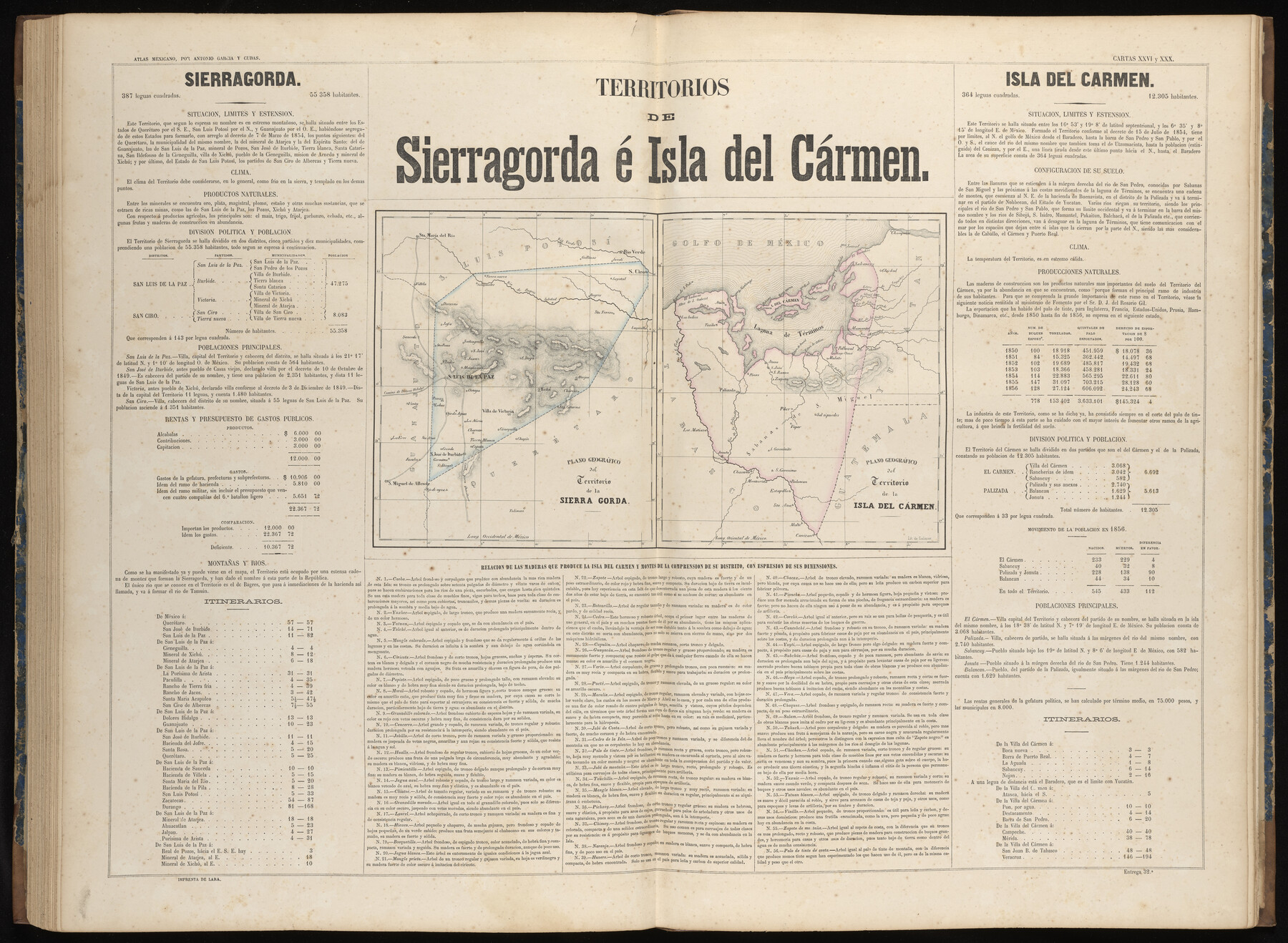
Territorios de Sierragorda e Isla del Carmen
-
Map/Doc
97011
-
Collection
General Map Collection
-
Object Dates
1858 (Publication Date)
-
People and Organizations
Antonio García y Cubas (Cartographer)
-
Subjects
Atlas Mexico
-
Height x Width
22.9 x 31.2 inches
58.2 x 79.3 cm
-
Medium
paper, etching/engraving/lithograph
-
Comments
Map 30 of 32 from "Atlas Geografico, Estadistico e Historico de la Republica Mexicana" (95689)
Related maps
Atlas Geográfico, Estadístico é Histórico de la República Mexicana

Atlas Geográfico, Estadístico é Histórico de la República Mexicana
Map/Doc 95689
Part of: General Map Collection
Map of Cooke County originally Fannin Land District

Print $20.00
- Digital $50.00
Map of Cooke County originally Fannin Land District
1858
Size 25.4 x 18.9 inches
Map/Doc 950
Kerr County Boundary File 55

Print $64.00
- Digital $50.00
Kerr County Boundary File 55
Size 8.7 x 3.5 inches
Map/Doc 64826
Goliad County

Print $20.00
- Digital $50.00
Goliad County
1946
Size 44.0 x 46.1 inches
Map/Doc 95509
[Metropolitan Areas of Texas]
![96824, [Metropolitan Areas of Texas], General Map Collection](https://historictexasmaps.com/wmedia_w700/maps/96824.tif.jpg)
[Metropolitan Areas of Texas]
1994
Size 33.6 x 36.1 inches
Map/Doc 96824
Flight Mission No. DQN-2K, Frame 114, Calhoun County

Print $20.00
- Digital $50.00
Flight Mission No. DQN-2K, Frame 114, Calhoun County
1953
Size 18.5 x 22.2 inches
Map/Doc 84290
Liberty County Rolled Sketch B

Print $20.00
- Digital $50.00
Liberty County Rolled Sketch B
Size 34.9 x 28.2 inches
Map/Doc 9570
Map of the First Division of the Chicago, Texas & Mexican-Central Railway

Print $40.00
- Digital $50.00
Map of the First Division of the Chicago, Texas & Mexican-Central Railway
Size 26.1 x 96.3 inches
Map/Doc 64467

Flight Mission No. DQN-2K, Frame 115, Calhoun County

Print $20.00
- Digital $50.00
Flight Mission No. DQN-2K, Frame 115, Calhoun County
1953
Size 18.6 x 22.3 inches
Map/Doc 84291
Map showing survey for proposed ship channel from Brownsville to Brazos Santiago Pass

Print $20.00
- Digital $50.00
Map showing survey for proposed ship channel from Brownsville to Brazos Santiago Pass
1912
Size 18.1 x 28.0 inches
Map/Doc 72899
Map of the Republic of Texas showing its division into counties and latest improvements too

Print $20.00
- Digital $50.00
Map of the Republic of Texas showing its division into counties and latest improvements too
1837
Size 12.3 x 9.6 inches
Map/Doc 76874
Starr County Rolled Sketch 12

Print $20.00
- Digital $50.00
Starr County Rolled Sketch 12
1912
Size 19.5 x 15.5 inches
Map/Doc 7799
You may also like
Wichita County Working Sketch 8

Print $20.00
- Digital $50.00
Wichita County Working Sketch 8
1919
Size 18.3 x 37.7 inches
Map/Doc 72517
Terrell County Sketch File 28

Print $20.00
- Digital $50.00
Terrell County Sketch File 28
1939
Size 18.3 x 22.8 inches
Map/Doc 12425
Flight Mission No. BRA-6M, Frame 77, Jefferson County

Print $20.00
- Digital $50.00
Flight Mission No. BRA-6M, Frame 77, Jefferson County
1953
Size 18.6 x 22.6 inches
Map/Doc 85421
Angelina County Rolled Sketch 1

Print $20.00
- Digital $50.00
Angelina County Rolled Sketch 1
Size 30.4 x 29.6 inches
Map/Doc 77184
The Mexican Municipalities. On the Eve of Texas Independence, 1836

Print $20.00
The Mexican Municipalities. On the Eve of Texas Independence, 1836
2020
Size 17.2 x 21.6 inches
Map/Doc 96013
English Field Notes of the Spanish Archives - Book 12

English Field Notes of the Spanish Archives - Book 12
1832
Map/Doc 96538
Aransas County Rolled Sketch 12

Print $20.00
- Digital $50.00
Aransas County Rolled Sketch 12
Size 17.6 x 11.1 inches
Map/Doc 77191
Dickens County

Print $20.00
- Digital $50.00
Dickens County
1915
Size 42.4 x 39.3 inches
Map/Doc 4722
Burleson County Working Sketch 27

Print $20.00
- Digital $50.00
Burleson County Working Sketch 27
1981
Size 23.8 x 12.2 inches
Map/Doc 67746
Harris County Rolled Sketch O

Print $20.00
- Digital $50.00
Harris County Rolled Sketch O
Size 19.3 x 28.9 inches
Map/Doc 6141
Flight Mission No. DIX-7P, Frame 93, Aransas County

Print $20.00
- Digital $50.00
Flight Mission No. DIX-7P, Frame 93, Aransas County
1956
Size 18.6 x 22.6 inches
Map/Doc 83887
Erath County Sketch File 7

Print $4.00
- Digital $50.00
Erath County Sketch File 7
Size 6.8 x 7.3 inches
Map/Doc 22267