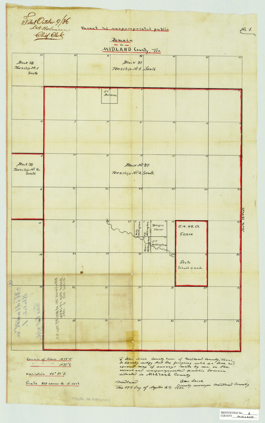
Midland County Sketch File 1
Vacant and Unappropriated Public Domain in Midland County, Texas
-
Map/Doc
12079
-
Collection
General Map Collection
-
Object Dates
9/17/1886 (Creation Date)
10/9/1886 (File Date)
-
People and Organizations
Otto Lerch (Surveyor/Engineer)
-
Counties
Midland
-
Subjects
Surveying Sketch File
-
Height x Width
25.7 x 16.1 inches
65.3 x 40.9 cm
-
Medium
paper, manuscript
-
Scale
1:950
Part of: General Map Collection
Map of Padre Island Showing Location of Zoning Districts

Print $20.00
- Digital $50.00
Map of Padre Island Showing Location of Zoning Districts
1971
Size 18.7 x 26.6 inches
Map/Doc 4808
Terrell County Rolled Sketch 56

Print $20.00
- Digital $50.00
Terrell County Rolled Sketch 56
1986
Size 36.6 x 42.0 inches
Map/Doc 9992
Map of Throckmorton County Young Land District

Print $20.00
- Digital $50.00
Map of Throckmorton County Young Land District
1859
Size 25.2 x 20.3 inches
Map/Doc 4078
Bandera County Working Sketch 49

Print $20.00
- Digital $50.00
Bandera County Working Sketch 49
1983
Size 28.2 x 43.3 inches
Map/Doc 67645
Flight Mission No. CGI-4N, Frame 192, Cameron County

Print $20.00
- Digital $50.00
Flight Mission No. CGI-4N, Frame 192, Cameron County
1955
Size 18.6 x 22.2 inches
Map/Doc 84695
Flight Mission No. BRA-7M, Frame 186, Jefferson County

Print $20.00
- Digital $50.00
Flight Mission No. BRA-7M, Frame 186, Jefferson County
1953
Size 18.4 x 22.2 inches
Map/Doc 85554
Kerr County Rolled Sketch 27

Print $20.00
- Digital $50.00
Kerr County Rolled Sketch 27
1983
Size 33.1 x 33.5 inches
Map/Doc 6506
Karnes County Sketch File 11

Print $4.00
- Digital $50.00
Karnes County Sketch File 11
1885
Size 10.5 x 8.1 inches
Map/Doc 28602
Loving County Sketch File 8

Print $44.00
- Digital $50.00
Loving County Sketch File 8
2002
Size 11.2 x 8.7 inches
Map/Doc 76377

Irion County Rolled Sketch 7

Print $20.00
- Digital $50.00
Irion County Rolled Sketch 7
Size 43.9 x 33.8 inches
Map/Doc 9250
McLennan County Sketch File 41

Print $44.00
- Digital $50.00
McLennan County Sketch File 41
1963
Size 11.1 x 8.6 inches
Map/Doc 31319
You may also like
Zavala County

Print $20.00
- Digital $50.00
Zavala County
1915
Size 38.6 x 46.6 inches
Map/Doc 16940
Translations of Titles issued under the Second Contract [500 Families] of Stephen F. Austin with the Government of Coahuila & Texas - Volume 1
![94546, Translations of Titles issued under the Second Contract [500 Families] of Stephen F. Austin with the Government of Coahuila & Texas - Volume 1, Historical Volumes](https://historictexasmaps.com/wmedia_w700/pdf_converted_jpg/qi_pdf_thumbnail_39135.jpg)
Translations of Titles issued under the Second Contract [500 Families] of Stephen F. Austin with the Government of Coahuila & Texas - Volume 1
1840
Map/Doc 94546
Flight Mission No. DCL-6C, Frame 95, Kenedy County

Print $20.00
- Digital $50.00
Flight Mission No. DCL-6C, Frame 95, Kenedy County
1943
Size 18.6 x 22.3 inches
Map/Doc 85925
General Highway Map, Harris County, Texas

Print $20.00
General Highway Map, Harris County, Texas
1961
Size 24.9 x 18.0 inches
Map/Doc 79502
Flight Mission No. CRC-4R, Frame 71, Chambers County

Print $20.00
- Digital $50.00
Flight Mission No. CRC-4R, Frame 71, Chambers County
1956
Size 18.7 x 22.5 inches
Map/Doc 84875
La Salle County Rolled Sketch 16

Print $20.00
- Digital $50.00
La Salle County Rolled Sketch 16
1948
Size 26.7 x 20.9 inches
Map/Doc 6580
Webb County Working Sketch 11

Print $20.00
- Digital $50.00
Webb County Working Sketch 11
1921
Size 17.8 x 16.3 inches
Map/Doc 72376
Flight Mission No. DCL-7C, Frame 44, Kenedy County

Print $20.00
- Digital $50.00
Flight Mission No. DCL-7C, Frame 44, Kenedy County
1943
Size 15.4 x 15.2 inches
Map/Doc 86032
Midland County Sketch File 18

Print $4.00
- Digital $50.00
Midland County Sketch File 18
Size 14.7 x 8.1 inches
Map/Doc 31585
State Map of Kansas Showing Productive Geological Formation of Each Oil Field

Print $20.00
- Digital $50.00
State Map of Kansas Showing Productive Geological Formation of Each Oil Field
1937
Size 45.5 x 29.8 inches
Map/Doc 92043
Flight Mission No. BRA-16M, Frame 84, Jefferson County

Print $20.00
- Digital $50.00
Flight Mission No. BRA-16M, Frame 84, Jefferson County
1953
Size 18.6 x 22.1 inches
Map/Doc 85696
Flight Mission No. DQN-2K, Frame 114, Calhoun County

Print $20.00
- Digital $50.00
Flight Mission No. DQN-2K, Frame 114, Calhoun County
1953
Size 18.5 x 22.2 inches
Map/Doc 84290