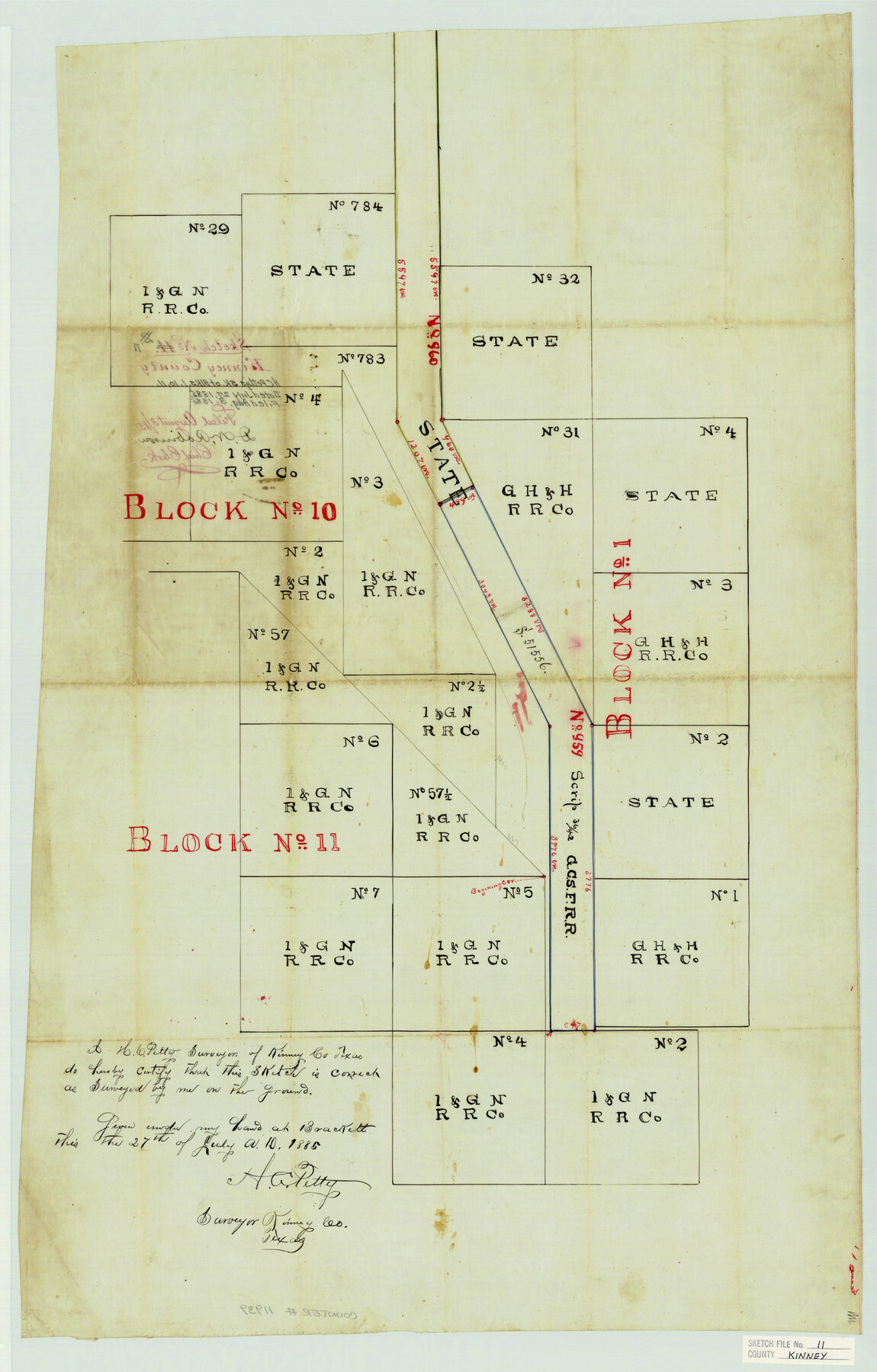
Kinney County Sketch File 11
[Sketch of the confluence of Blocks 1, 10 & 11, northwest of Brackettville]
-
Map/Doc
11939
-
Collection
General Map Collection
-
Object Dates
7/27/1885 (Creation Date)
8/3/1885 (File Date)
-
People and Organizations
H.C. Petty (Surveyor/Engineer)
-
Counties
Kinney
-
Subjects
Surveying Sketch File
-
Height x Width
28.3 x 18.1 inches
71.9 x 46.0 cm
-
Medium
paper, manuscript
Part of: General Map Collection

Pecos County Working Sketch 83

Print $20.00
- Digital $50.00
Pecos County Working Sketch 83
1961
Size 18.7 x 28.7 inches
Map/Doc 71555
Red River County Sketch File A

Print $40.00
- Digital $50.00
Red River County Sketch File A
1900
Size 20.1 x 23.8 inches
Map/Doc 12236
Kenedy County Rolled Sketch 13

Print $20.00
- Digital $50.00
Kenedy County Rolled Sketch 13
1946
Size 38.2 x 45.5 inches
Map/Doc 9334
Gregg County Rolled Sketch 7

Print $20.00
- Digital $50.00
Gregg County Rolled Sketch 7
1933
Size 24.6 x 42.0 inches
Map/Doc 6032
Map of Jones County

Print $20.00
- Digital $50.00
Map of Jones County
1898
Size 41.9 x 39.8 inches
Map/Doc 4996
Ward County Working Sketch 38

Print $40.00
- Digital $50.00
Ward County Working Sketch 38
1969
Size 62.2 x 30.3 inches
Map/Doc 72344
DeWitt County

Print $40.00
- Digital $50.00
DeWitt County
1987
Size 42.1 x 50.6 inches
Map/Doc 95481
Map of Texas Gulf Coast and Continental Shelf showing Natural Gas Pipe Lines

Print $40.00
- Digital $50.00
Map of Texas Gulf Coast and Continental Shelf showing Natural Gas Pipe Lines
1983
Size 40.9 x 59.1 inches
Map/Doc 75969
Map of Brazos County, Texas

Print $40.00
- Digital $50.00
Map of Brazos County, Texas
1926
Size 89.6 x 55.1 inches
Map/Doc 93648
Harris County Sketch File 81

Print $20.00
- Digital $50.00
Harris County Sketch File 81
Size 25.5 x 16.5 inches
Map/Doc 11669
Flight Mission No. DQO-8K, Frame 64, Galveston County

Print $20.00
- Digital $50.00
Flight Mission No. DQO-8K, Frame 64, Galveston County
1952
Size 18.6 x 22.4 inches
Map/Doc 85168
You may also like
Flight Mission No. DQO-8K, Frame 49, Galveston County

Print $20.00
- Digital $50.00
Flight Mission No. DQO-8K, Frame 49, Galveston County
1952
Size 18.7 x 22.3 inches
Map/Doc 85156
Upton County Rolled Sketch 60

Print $20.00
- Digital $50.00
Upton County Rolled Sketch 60
2021
Size 35.9 x 24.0 inches
Map/Doc 96569
Mitchell County Boundary File 1

Print $38.00
- Digital $50.00
Mitchell County Boundary File 1
Size 9.1 x 8.4 inches
Map/Doc 57334
General Highway Map. Detail of Cities and Towns in Bexar County, Texas [San Antonio and vicinity]
![79019, General Highway Map. Detail of Cities and Towns in Bexar County, Texas [San Antonio and vicinity], Texas State Library and Archives](https://historictexasmaps.com/wmedia_w700/maps/79019.tif.jpg)
Print $20.00
General Highway Map. Detail of Cities and Towns in Bexar County, Texas [San Antonio and vicinity]
1940
Size 18.6 x 25.0 inches
Map/Doc 79019
Flight Mission No. BRA-16M, Frame 119, Jefferson County

Print $20.00
- Digital $50.00
Flight Mission No. BRA-16M, Frame 119, Jefferson County
1953
Size 18.6 x 22.5 inches
Map/Doc 85729
Upton County Working Sketch 40

Print $40.00
- Digital $50.00
Upton County Working Sketch 40
1959
Size 37.5 x 63.7 inches
Map/Doc 69536
Swisher County Rolled Sketch 4

Print $20.00
- Digital $50.00
Swisher County Rolled Sketch 4
1904
Size 16.2 x 18.0 inches
Map/Doc 7905
Flight Mission No. DQN-5K, Frame 26, Calhoun County

Print $20.00
- Digital $50.00
Flight Mission No. DQN-5K, Frame 26, Calhoun County
1953
Size 18.6 x 22.3 inches
Map/Doc 84377
Map of Wheeler County

Print $20.00
- Digital $50.00
Map of Wheeler County
1899
Size 39.9 x 32.3 inches
Map/Doc 4138
Orange County Sketch File 14a

Print $4.00
- Digital $50.00
Orange County Sketch File 14a
1886
Size 8.1 x 10.2 inches
Map/Doc 33328
Working Sketch Compiled from Original Field Showing Surveys in Irion County Located by J. A. McDonald in 1856 and 1858

Print $20.00
- Digital $50.00
Working Sketch Compiled from Original Field Showing Surveys in Irion County Located by J. A. McDonald in 1856 and 1858
Size 13.1 x 13.8 inches
Map/Doc 92191
El Paso County Boundary File 14a

Print $7.00
- Digital $50.00
El Paso County Boundary File 14a
Size 11.1 x 8.7 inches
Map/Doc 53183