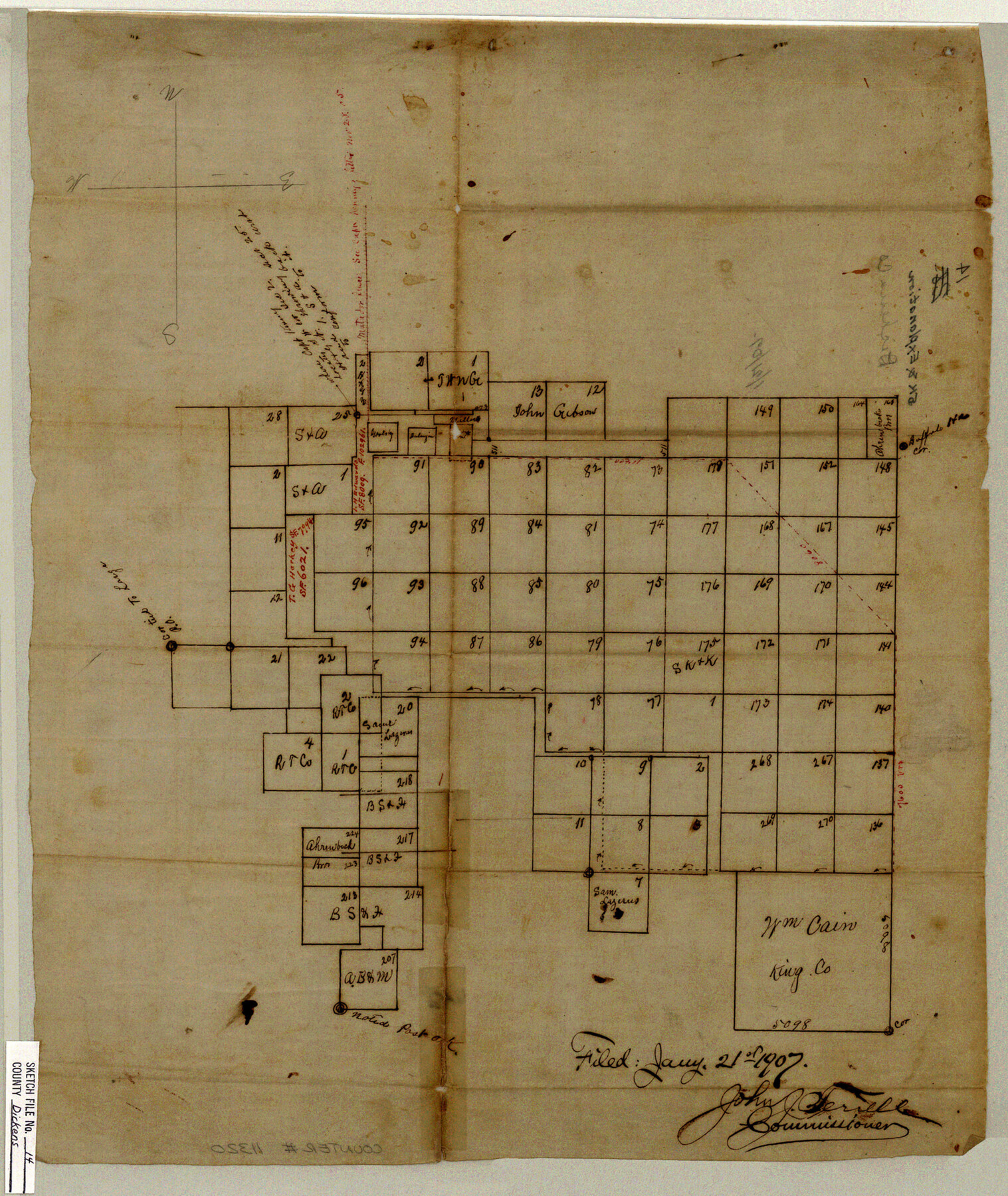
Dickens County Sketch File 14
[Sketch of surveys in the northeast part of Dickens County and northwest part of King County]
-
Map/Doc
11320
-
Collection
General Map Collection
-
Object Dates
1/21/1907 (File Date)
-
Counties
Dickens King
-
Subjects
Surveying Sketch File
-
Height x Width
19.6 x 16.6 inches
49.8 x 42.2 cm
-
Medium
paper, manuscript
Part of: General Map Collection
Flight Mission No. DIX-10P, Frame 184, Aransas County

Print $20.00
- Digital $50.00
Flight Mission No. DIX-10P, Frame 184, Aransas County
1956
Size 18.5 x 22.2 inches
Map/Doc 83974
Reeves County Rolled Sketch 22

Print $20.00
- Digital $50.00
Reeves County Rolled Sketch 22
1960
Size 40.8 x 20.9 inches
Map/Doc 7490
Houston County Working Sketch 36

Print $40.00
- Digital $50.00
Houston County Working Sketch 36
1987
Size 61.2 x 43.6 inches
Map/Doc 78231
Dimmit County Rolled Sketch 20A

Print $20.00
- Digital $50.00
Dimmit County Rolled Sketch 20A
1999
Size 24.9 x 36.5 inches
Map/Doc 6065
Flight Mission No. BRA-8M, Frame 117, Jefferson County

Print $20.00
- Digital $50.00
Flight Mission No. BRA-8M, Frame 117, Jefferson County
1953
Size 18.5 x 22.3 inches
Map/Doc 85613
Cameron County Rolled Sketch 26

Print $20.00
- Digital $50.00
Cameron County Rolled Sketch 26
1960
Size 18.0 x 24.4 inches
Map/Doc 5391
Flight Mission No. DQN-1K, Frame 34, Calhoun County

Print $20.00
- Digital $50.00
Flight Mission No. DQN-1K, Frame 34, Calhoun County
1953
Size 18.5 x 22.2 inches
Map/Doc 84139
Calhoun County Rolled Sketch 11

Print $3.00
- Digital $50.00
Calhoun County Rolled Sketch 11
1942
Size 10.8 x 16.3 inches
Map/Doc 5464
Brazoria County Sketch File 25

Print $8.00
- Digital $50.00
Brazoria County Sketch File 25
1875
Size 8.4 x 13.2 inches
Map/Doc 15024
Stonewall County Working Sketch 27

Print $20.00
- Digital $50.00
Stonewall County Working Sketch 27
1976
Size 20.7 x 29.9 inches
Map/Doc 62334
Coast Chart No. 210 - Aransas Pass and Corpus Christi Bay with the coast to latitude 27° 12', Texas

Print $20.00
- Digital $50.00
Coast Chart No. 210 - Aransas Pass and Corpus Christi Bay with the coast to latitude 27° 12', Texas
1907
Size 18.4 x 24.1 inches
Map/Doc 73453
Val Verde County Working Sketch 8

Print $20.00
- Digital $50.00
Val Verde County Working Sketch 8
1917
Size 31.4 x 32.0 inches
Map/Doc 72143
You may also like
Map showing the resurvey of Block M24 T. C. R.R. Co. in Hutchinson County, Texas

Print $20.00
- Digital $50.00
Map showing the resurvey of Block M24 T. C. R.R. Co. in Hutchinson County, Texas
Size 28.8 x 30.8 inches
Map/Doc 76178
Atlantic Coast to the Rocky Mountains

Atlantic Coast to the Rocky Mountains
1956
Size 42.5 x 29.4 inches
Map/Doc 94409
Map of Leon County

Print $40.00
- Digital $50.00
Map of Leon County
1916
Size 48.4 x 40.8 inches
Map/Doc 16877
[Lgs. 192-195, 176-179]
![90254, [Lgs. 192-195, 176-179], Twichell Survey Records](https://historictexasmaps.com/wmedia_w700/maps/90254-1.tif.jpg)
Print $20.00
- Digital $50.00
[Lgs. 192-195, 176-179]
Size 18.2 x 25.2 inches
Map/Doc 90254
Grayson County Working Sketch 20

Print $20.00
- Digital $50.00
Grayson County Working Sketch 20
1956
Size 25.4 x 31.3 inches
Map/Doc 63259
Presidio County Working Sketch 135

Print $20.00
- Digital $50.00
Presidio County Working Sketch 135
1988
Size 23.6 x 24.4 inches
Map/Doc 71813
Township 2 North Range 12 West, North Western District, Louisiana

Print $20.00
- Digital $50.00
Township 2 North Range 12 West, North Western District, Louisiana
1884
Size 19.6 x 24.7 inches
Map/Doc 65875
[Surveying Sketch of H. & T. C. R.R. Co. surveys, et al, unknown county]
![75988, [Surveying Sketch of H. & T. C. R.R. Co. surveys, et al, unknown county], Maddox Collection](https://historictexasmaps.com/wmedia_w700/maps/75988.tif.jpg)
Print $20.00
- Digital $50.00
[Surveying Sketch of H. & T. C. R.R. Co. surveys, et al, unknown county]
Size 21.0 x 25.7 inches
Map/Doc 75988
Kimble County Boundary File 4

Print $26.00
- Digital $50.00
Kimble County Boundary File 4
Size 7.5 x 7.3 inches
Map/Doc 64868
Flight Mission No. DQN-2K, Frame 161, Calhoun County

Print $20.00
- Digital $50.00
Flight Mission No. DQN-2K, Frame 161, Calhoun County
1953
Size 18.5 x 22.3 inches
Map/Doc 84323
Henderson County Working Sketch 25

Print $20.00
- Digital $50.00
Henderson County Working Sketch 25
1954
Size 42.0 x 31.2 inches
Map/Doc 66158
Liberty County Working Sketch 67

Print $20.00
- Digital $50.00
Liberty County Working Sketch 67
1971
Size 35.3 x 44.5 inches
Map/Doc 70527