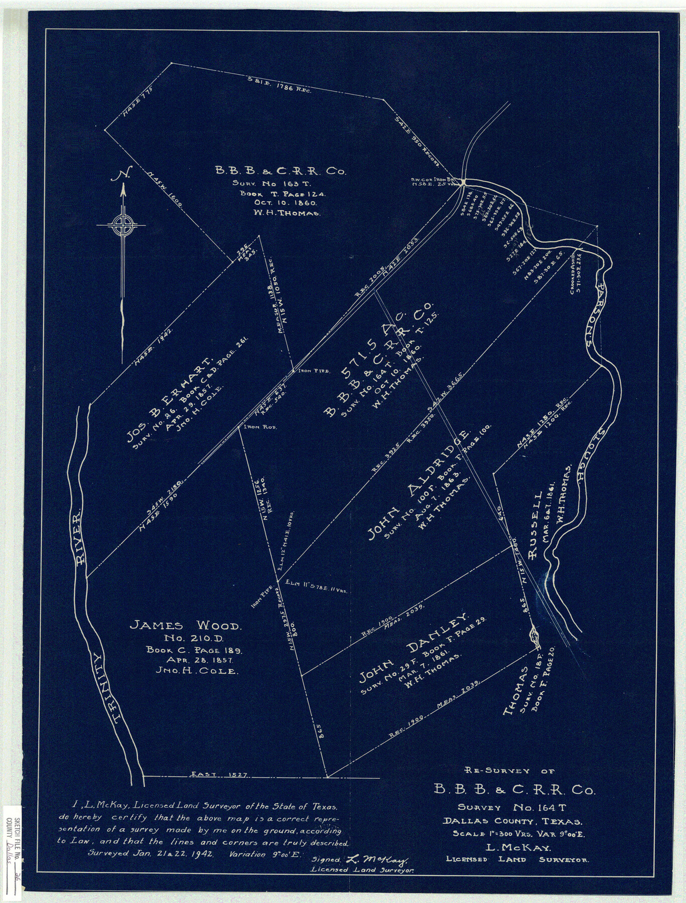
Dallas County Sketch File 26
Re-Survey of B.B.B.&C. R.R. Co. Survey No. 164 T Dallas County, Texas
-
Map/Doc
11289
-
Collection
General Map Collection
-
Object Dates
1942/1/22 (Creation Date)
1942/2/20 (File Date)
-
People and Organizations
L. McKay (Surveyor/Engineer)
-
Counties
Dallas
-
Subjects
Surveying Sketch File
-
Height x Width
24.9 x 18.9 inches
63.2 x 48.0 cm
-
Medium
blueprint/diazo
-
Scale
1:300
-
Features
Parson's Slough
Trinity River
Part of: General Map Collection
Smith County Working Sketch 16

Print $20.00
- Digital $50.00
Smith County Working Sketch 16
1988
Size 33.6 x 44.9 inches
Map/Doc 63901
Hidalgo County Working Sketch 10

Print $40.00
- Digital $50.00
Hidalgo County Working Sketch 10
2011
Size 59.9 x 29.5 inches
Map/Doc 89998
Aransas County Rolled Sketch 34

Print $42.00
- Digital $50.00
Aransas County Rolled Sketch 34
2004
Size 24.5 x 36.5 inches
Map/Doc 83637
Map of Callahan County

Print $20.00
- Digital $50.00
Map of Callahan County
1859
Size 24.5 x 19.4 inches
Map/Doc 3360
Crockett County Rolled Sketch 37

Print $20.00
- Digital $50.00
Crockett County Rolled Sketch 37
Size 36.7 x 29.3 inches
Map/Doc 5589
Trinity River, Sand Lake Sheet

Print $40.00
- Digital $50.00
Trinity River, Sand Lake Sheet
1922
Size 29.4 x 49.7 inches
Map/Doc 65184
Liberty County Working Sketch 3

Print $20.00
- Digital $50.00
Liberty County Working Sketch 3
1891
Size 16.2 x 13.2 inches
Map/Doc 70462
Burnet County Working Sketch 11

Print $20.00
- Digital $50.00
Burnet County Working Sketch 11
1975
Size 26.5 x 28.9 inches
Map/Doc 67854
[Corpus Christi & Rio Grande Certificates]
![64492, [Corpus Christi & Rio Grande Certificates], General Map Collection](https://historictexasmaps.com/wmedia_w700/pdf_converted_jpg/qi_pdf_thumbnail_19225.jpg)
Print $16.00
- Digital $50.00
[Corpus Christi & Rio Grande Certificates]
1874
Size 14.3 x 8.7 inches
Map/Doc 64492
Clay County Sketch File 24

Print $4.00
- Digital $50.00
Clay County Sketch File 24
1881
Size 18.9 x 23.0 inches
Map/Doc 11087
County and Railroad Map of Texas

Print $20.00
- Digital $50.00
County and Railroad Map of Texas
1876
Size 17.0 x 16.0 inches
Map/Doc 93624
Brewster County Working Sketch 73

Print $20.00
- Digital $50.00
Brewster County Working Sketch 73
1965
Size 24.0 x 32.1 inches
Map/Doc 67673
You may also like
San Jacinto County Sketch File 22

Print $136.00
San Jacinto County Sketch File 22
1935
Size 11.3 x 8.7 inches
Map/Doc 35734
Wheeler County

Print $20.00
- Digital $50.00
Wheeler County
1878
Size 18.5 x 16.6 inches
Map/Doc 4140
Galveston County NRC Article 33.136 Sketch 15

Print $24.00
- Digital $50.00
Galveston County NRC Article 33.136 Sketch 15
2002
Size 23.0 x 35.0 inches
Map/Doc 77046
Map of Pecos County, Texas

Print $40.00
- Digital $50.00
Map of Pecos County, Texas
Size 53.2 x 44.9 inches
Map/Doc 89880
Navigation Maps of Gulf Intracoastal Waterway, Port Arthur to Brownsville, Texas

Print $4.00
- Digital $50.00
Navigation Maps of Gulf Intracoastal Waterway, Port Arthur to Brownsville, Texas
1951
Size 16.6 x 21.5 inches
Map/Doc 65440
Martin County Rolled Sketch 7

Print $20.00
- Digital $50.00
Martin County Rolled Sketch 7
1929
Size 23.0 x 31.2 inches
Map/Doc 6667
Wilbarger County Rolled Sketch 9

Print $20.00
- Digital $50.00
Wilbarger County Rolled Sketch 9
Size 23.8 x 28.1 inches
Map/Doc 8258
General Highway Map, Goliad County, Texas

Print $20.00
General Highway Map, Goliad County, Texas
1940
Size 18.7 x 25.1 inches
Map/Doc 79101
Shelby County Working Sketch 23b

Print $20.00
- Digital $50.00
Shelby County Working Sketch 23b
1983
Size 36.6 x 24.7 inches
Map/Doc 63877
Texas, nach den besten Quellen entw. u. gez. vom Hauptm. Radefeld

Print $20.00
- Digital $50.00
Texas, nach den besten Quellen entw. u. gez. vom Hauptm. Radefeld
1851
Size 15.0 x 18.4 inches
Map/Doc 93776
Map of Scurry County

Print $20.00
- Digital $50.00
Map of Scurry County
Size 17.8 x 22.7 inches
Map/Doc 92921
Flight Mission No. BRE-1P, Frame 125, Nueces County

Print $20.00
- Digital $50.00
Flight Mission No. BRE-1P, Frame 125, Nueces County
1956
Size 18.6 x 22.7 inches
Map/Doc 86691