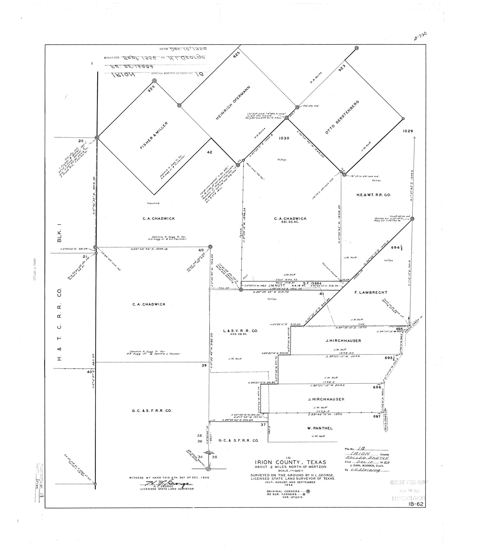
Irion County Rolled Sketch 18
[Sketch of SF-15884, J.M. Nutt and surrounding areas]
-
Map/Doc
6326
-
Collection
General Map Collection
-
Object Dates
1956 (Survey Date)
1956/12/10 (File Date)
1956/12/6 (Creation Date)
-
People and Organizations
H.L. George (Surveyor/Engineer)
-
Counties
Irion
-
Subjects
Surveying Rolled Sketch
-
Height x Width
30.5 x 26.3 inches
77.5 x 66.8 cm
-
Scale
1" = 300 varas
Part of: General Map Collection
Glasscock County Sketch File 25

Print $20.00
- Digital $50.00
Glasscock County Sketch File 25
1951
Size 28.8 x 20.6 inches
Map/Doc 11566
Real County Working Sketch 69

Print $20.00
- Digital $50.00
Real County Working Sketch 69
1942
Size 42.4 x 35.4 inches
Map/Doc 71961
Hardin County Working Sketch 21

Print $20.00
- Digital $50.00
Hardin County Working Sketch 21
1947
Size 43.2 x 38.4 inches
Map/Doc 63419
Pecos County Working Sketch 142

Print $40.00
- Digital $50.00
Pecos County Working Sketch 142
2007
Size 38.0 x 63.4 inches
Map/Doc 88610
Bien & Sterner's New Rail Road Map of the United States and the Canadas compiled from the latest surveys & locations under the direction of Zerah Colburn Esq., editor of the Rail Road Advocate

Print $20.00
- Digital $50.00
Bien & Sterner's New Rail Road Map of the United States and the Canadas compiled from the latest surveys & locations under the direction of Zerah Colburn Esq., editor of the Rail Road Advocate
1855
Size 27.5 x 32.3 inches
Map/Doc 95963
San Augustine County Rolled Sketch 2

Print $20.00
- Digital $50.00
San Augustine County Rolled Sketch 2
1947
Size 29.1 x 23.1 inches
Map/Doc 7554
Controlled Mosaic by Jack Amman Photogrammetric Engineers, Inc - Sheet 1

Print $20.00
- Digital $50.00
Controlled Mosaic by Jack Amman Photogrammetric Engineers, Inc - Sheet 1
1954
Size 20.0 x 24.0 inches
Map/Doc 83445
Intracoastal Waterway, Houma, LA to Corpus Christi, TX

Print $20.00
- Digital $50.00
Intracoastal Waterway, Houma, LA to Corpus Christi, TX
Size 18.9 x 27.9 inches
Map/Doc 61906
Castro County Sketch File 4b

Print $4.00
- Digital $50.00
Castro County Sketch File 4b
Size 13.5 x 8.9 inches
Map/Doc 17467
Kent County Working Sketch 1

Print $20.00
- Digital $50.00
Kent County Working Sketch 1
1930
Size 29.9 x 24.8 inches
Map/Doc 70007
Brooks County Sketch File 6

Print $12.00
- Digital $50.00
Brooks County Sketch File 6
1941
Size 13.2 x 8.3 inches
Map/Doc 16560
Roberts County Working Sketch 20

Print $20.00
- Digital $50.00
Roberts County Working Sketch 20
1977
Size 25.6 x 32.9 inches
Map/Doc 63546
You may also like
[Block K, Public School Land]
![92907, [Block K, Public School Land], Twichell Survey Records](https://historictexasmaps.com/wmedia_w700/maps/92907-1.tif.jpg)
Print $20.00
- Digital $50.00
[Block K, Public School Land]
1902
Size 17.9 x 32.8 inches
Map/Doc 92907
Marion County Working Sketch 43

Print $20.00
- Digital $50.00
Marion County Working Sketch 43
2002
Size 28.6 x 29.0 inches
Map/Doc 78214
Terrell County Working Sketch 37

Print $20.00
- Digital $50.00
Terrell County Working Sketch 37
1950
Size 24.5 x 24.1 inches
Map/Doc 62130
Flight Mission No. DCL-7C, Frame 119, Kenedy County

Print $20.00
- Digital $50.00
Flight Mission No. DCL-7C, Frame 119, Kenedy County
1943
Size 18.5 x 22.3 inches
Map/Doc 86084

Hamilton County Working Sketch 14

Print $20.00
- Digital $50.00
Hamilton County Working Sketch 14
1949
Size 30.1 x 35.4 inches
Map/Doc 63352
[Sketch of Blocks 4X, E, T, C42, and Y with Double Lake Corner tie to Rhoads Fisher Corners]
![91940, [Sketch of Blocks 4X, E, T, C42, and Y with Double Lake Corner tie to Rhoads Fisher Corners], Twichell Survey Records](https://historictexasmaps.com/wmedia_w700/maps/91940-2.tif.jpg)
Print $20.00
- Digital $50.00
[Sketch of Blocks 4X, E, T, C42, and Y with Double Lake Corner tie to Rhoads Fisher Corners]
Size 34.0 x 11.5 inches
Map/Doc 91940
Map of Liberty County Texas

Print $20.00
- Digital $50.00
Map of Liberty County Texas
1895
Size 29.7 x 29.4 inches
Map/Doc 3811
Louisiana and Texas Intracoastal Waterway - Gilchrist to Port Bolivar, Maintenance Dredging - Sheet 2

Print $20.00
- Digital $50.00
Louisiana and Texas Intracoastal Waterway - Gilchrist to Port Bolivar, Maintenance Dredging - Sheet 2
1937
Size 31.0 x 40.8 inches
Map/Doc 61821
Map of Texas Showing Routes of Transportation of Cattle

Print $20.00
Map of Texas Showing Routes of Transportation of Cattle
1881
Size 11.0 x 10.9 inches
Map/Doc 95718
Cooke County Sketch File 12

Print $4.00
- Digital $50.00
Cooke County Sketch File 12
Size 10.1 x 8.3 inches
Map/Doc 19246
Culberson County Working Sketch 70

Print $40.00
- Digital $50.00
Culberson County Working Sketch 70
1975
Size 50.3 x 32.2 inches
Map/Doc 68524