Mitchell County Sketch File 10
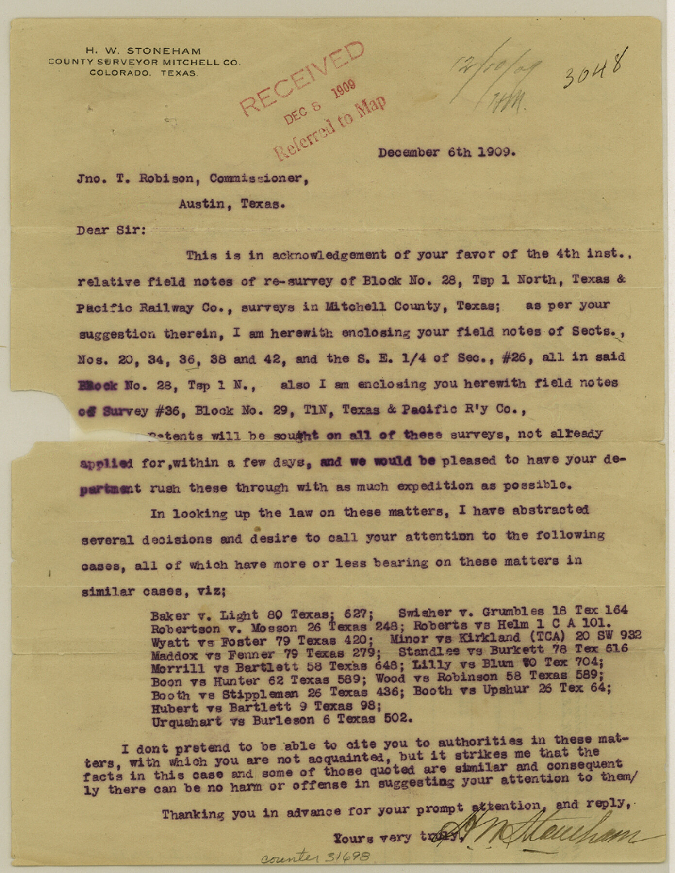
[Explanation of resurvey of Block 28, Township 1N]
-
Map/Doc
31698
-
Collection
General Map Collection
-
Object Dates
12/6/1909 (Creation Date)
12/8/1909 (File Date)
12/6/1909 (Correspondence Date)
-
People and Organizations
H.W. Stoneham (Surveyor/Engineer)
-
Counties
Mitchell
-
Subjects
Surveying Sketch File
-
Height x Width
11.3 x 8.8 inches
28.7 x 22.4 cm
-
Medium
paper, print
-
Comments
See Mitchell County Sketch File 8 (12098) for sketch, and Mitchell County Sketch File 9 (31694) for explanation.
Related maps
Mitchell County Sketch File 8

Print $20.00
- Digital $50.00
Mitchell County Sketch File 8
1909
Size 26.9 x 20.9 inches
Map/Doc 12098
Mitchell County Sketch File 9

Print $8.00
- Digital $50.00
Mitchell County Sketch File 9
1909
Size 11.4 x 8.6 inches
Map/Doc 31694
Part of: General Map Collection
Atascosa County Working Sketch 20

Print $20.00
- Digital $50.00
Atascosa County Working Sketch 20
1953
Size 22.9 x 25.5 inches
Map/Doc 67216
Flight Mission No. DQN-2K, Frame 44, Calhoun County

Print $20.00
- Digital $50.00
Flight Mission No. DQN-2K, Frame 44, Calhoun County
1953
Size 18.4 x 22.1 inches
Map/Doc 84249
Oldham County Sketch File 19

Print $20.00
- Digital $50.00
Oldham County Sketch File 19
1904
Size 18.2 x 24.0 inches
Map/Doc 12116
Brooks County Working Sketch 8

Print $20.00
- Digital $50.00
Brooks County Working Sketch 8
1928
Size 27.6 x 23.3 inches
Map/Doc 67792
Flight Mission No. CUG-1P, Frame 107, Kleberg County

Print $20.00
- Digital $50.00
Flight Mission No. CUG-1P, Frame 107, Kleberg County
1956
Size 18.5 x 22.3 inches
Map/Doc 86157
Childress County Rolled Sketch 9C

Print $20.00
- Digital $50.00
Childress County Rolled Sketch 9C
Size 13.8 x 17.9 inches
Map/Doc 5449
Morris County Working Sketch 6

Print $20.00
- Digital $50.00
Morris County Working Sketch 6
1985
Size 35.8 x 36.7 inches
Map/Doc 71205
Dimmit County Working Sketch 36

Print $20.00
- Digital $50.00
Dimmit County Working Sketch 36
1962
Size 28.0 x 40.7 inches
Map/Doc 68697
Flight Mission No. DQN-6K, Frame 71, Calhoun County

Print $20.00
- Digital $50.00
Flight Mission No. DQN-6K, Frame 71, Calhoun County
1953
Size 18.5 x 22.2 inches
Map/Doc 84443
Subdivision Plat of Blue Ridge State Farm Showing 18 Tracts

Print $20.00
- Digital $50.00
Subdivision Plat of Blue Ridge State Farm Showing 18 Tracts
Size 27.0 x 27.4 inches
Map/Doc 62978
Hudspeth County Rolled Sketch 44

Print $20.00
- Digital $50.00
Hudspeth County Rolled Sketch 44
1951
Size 12.1 x 11.5 inches
Map/Doc 9217

You may also like
Montague County Working Sketch 35

Print $20.00
- Digital $50.00
Montague County Working Sketch 35
1980
Size 24.8 x 31.9 inches
Map/Doc 71101
Tyler County Sketch File 2a

Print $11.00
- Digital $50.00
Tyler County Sketch File 2a
1851
Size 8.3 x 7.8 inches
Map/Doc 38617
Hunt County Rolled Sketch 5

Print $20.00
- Digital $50.00
Hunt County Rolled Sketch 5
1966
Size 24.7 x 24.4 inches
Map/Doc 6273
Map of Land in State Mineral Land Permit No. 2838 held by E. W. Fry and E. A. Giraud

Print $20.00
- Digital $50.00
Map of Land in State Mineral Land Permit No. 2838 held by E. W. Fry and E. A. Giraud
1919
Size 18.4 x 37.3 inches
Map/Doc 91837
Llano County Sketch File 14

Print $22.00
- Digital $50.00
Llano County Sketch File 14
Size 8.0 x 12.7 inches
Map/Doc 30389
Coke County Sketch File 24

Print $6.00
- Digital $50.00
Coke County Sketch File 24
1927
Size 11.1 x 8.8 inches
Map/Doc 18615
Oldham County Working Sketch 6

Print $40.00
- Digital $50.00
Oldham County Working Sketch 6
1981
Size 32.4 x 50.4 inches
Map/Doc 71328
Panola County Sketch File 1a

Print $4.00
- Digital $50.00
Panola County Sketch File 1a
1855
Size 12.7 x 7.9 inches
Map/Doc 33445
Hill County Rolled Sketch 1

Print $20.00
- Digital $50.00
Hill County Rolled Sketch 1
1950
Size 13.1 x 41.0 inches
Map/Doc 6214
Kimble County Sketch File 31

Print $20.00
- Digital $50.00
Kimble County Sketch File 31
1890
Size 26.0 x 24.3 inches
Map/Doc 11929
Hays County Working Sketch 2

Print $20.00
- Digital $50.00
Hays County Working Sketch 2
1920
Size 26.1 x 27.1 inches
Map/Doc 66076
Presidio County Sketch File F

Print $2.00
- Digital $50.00
Presidio County Sketch File F
Size 15.5 x 8.2 inches
Map/Doc 34428