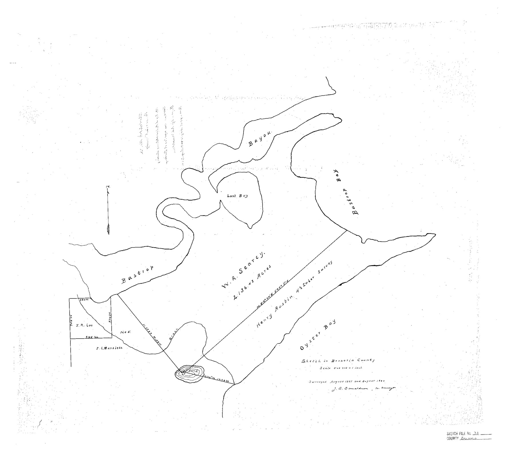
Brazoria County Sketch File 33
Sketch in Brazoria County [showing surveys on Bastrop Bay and Oyster Bay]
-
Map/Doc
10957
-
Collection
General Map Collection
-
Object Dates
1899 (Survey Date)
1900 (Survey Date)
-
People and Organizations
J.A. Donaldson (Surveyor/Engineer)
-
Counties
Brazoria
-
Subjects
Surveying Sketch File
-
Height x Width
21.9 x 24.1 inches
55.6 x 61.2 cm
-
Medium
linen, manuscript
-
Scale
1" = 500 varas
-
Features
Bastrop Bay
Lost Bay
Bastrop Bayou
Oyster Bay
Part of: General Map Collection
Cooke County Working Sketch 19

Print $20.00
- Digital $50.00
Cooke County Working Sketch 19
1954
Size 23.8 x 20.7 inches
Map/Doc 68256
Upton County Sketch File 36

Print $14.00
- Digital $50.00
Upton County Sketch File 36
1952
Size 11.3 x 8.8 inches
Map/Doc 38893
Brewster County Rolled Sketch 27

Print $40.00
- Digital $50.00
Brewster County Rolled Sketch 27
Size 35.1 x 48.8 inches
Map/Doc 8474
Henderson County Boundary File 2b

Print $14.00
- Digital $50.00
Henderson County Boundary File 2b
Size 14.1 x 8.7 inches
Map/Doc 54662
Flight Mission No. DAG-23K, Frame 152, Matagorda County

Print $20.00
- Digital $50.00
Flight Mission No. DAG-23K, Frame 152, Matagorda County
1953
Size 15.9 x 15.9 inches
Map/Doc 86500
Map of Dallas County

Print $20.00
- Digital $50.00
Map of Dallas County
1886
Size 21.9 x 17.0 inches
Map/Doc 3466
Matagorda County Sketch File 33

Print $6.00
- Digital $50.00
Matagorda County Sketch File 33
1938
Size 14.2 x 8.8 inches
Map/Doc 30817
Flight Mission No. DCL-7C, Frame 25, Kenedy County

Print $20.00
- Digital $50.00
Flight Mission No. DCL-7C, Frame 25, Kenedy County
1943
Size 15.4 x 15.4 inches
Map/Doc 86017
Erath County Sketch File 15

Print $4.00
- Digital $50.00
Erath County Sketch File 15
1872
Size 6.2 x 7.6 inches
Map/Doc 22292
Brewster County Sketch File FN-30

Print $4.00
- Digital $50.00
Brewster County Sketch File FN-30
1975
Size 12.0 x 8.7 inches
Map/Doc 15850
Randall County Sketch File 11

Print $4.00
- Digital $50.00
Randall County Sketch File 11
1944
Size 3.4 x 5.7 inches
Map/Doc 34974
Zavala County Sketch File 11

Print $4.00
- Digital $50.00
Zavala County Sketch File 11
1885
Size 14.4 x 8.8 inches
Map/Doc 41270
You may also like
Stephens County Working Sketch 15

Print $20.00
- Digital $50.00
Stephens County Working Sketch 15
1963
Size 35.8 x 36.8 inches
Map/Doc 63958
Val Verde County Working Sketch 36

Print $20.00
- Digital $50.00
Val Verde County Working Sketch 36
1942
Size 34.5 x 44.9 inches
Map/Doc 72171
[Mrs. May Vinson Survey]
![91877, [Mrs. May Vinson Survey], Twichell Survey Records](https://historictexasmaps.com/wmedia_w700/maps/91877-1.tif.jpg)
Print $20.00
- Digital $50.00
[Mrs. May Vinson Survey]
Size 26.7 x 14.8 inches
Map/Doc 91877
Frio County Sketch File 10

Print $20.00
- Digital $50.00
Frio County Sketch File 10
1906
Size 19.3 x 23.2 inches
Map/Doc 11518
![94161, Austin and Vicinity [Verso], General Map Collection](https://historictexasmaps.com/wmedia_w700/maps/94161.tif.jpg)
Marion County Working Sketch 35

Print $20.00
- Digital $50.00
Marion County Working Sketch 35
1985
Size 27.3 x 28.2 inches
Map/Doc 70811
Potter County Sketch File 18

Print $20.00
- Digital $50.00
Potter County Sketch File 18
Size 34.3 x 43.4 inches
Map/Doc 10577
Rusk County Sketch File 45

Print $8.00
Rusk County Sketch File 45
1959
Size 11.3 x 8.8 inches
Map/Doc 35591
[Blks. B9, J, D19, John Walker]
![90482, [Blks. B9, J, D19, John Walker], Twichell Survey Records](https://historictexasmaps.com/wmedia_w700/maps/90482-1.tif.jpg)
Print $20.00
- Digital $50.00
[Blks. B9, J, D19, John Walker]
Size 27.8 x 15.9 inches
Map/Doc 90482
Map Showing a Resurvey of Part of Blk. I, H. &. G. N. Ry. Co. Pecos County, Texas, following field notes copied from Jacob Kuechler's field book of his original survey made in October and November 1876

Print $20.00
- Digital $50.00
Map Showing a Resurvey of Part of Blk. I, H. &. G. N. Ry. Co. Pecos County, Texas, following field notes copied from Jacob Kuechler's field book of his original survey made in October and November 1876
1930
Size 19.2 x 14.4 inches
Map/Doc 91549
Polk County Working Sketch 4

Print $20.00
- Digital $50.00
Polk County Working Sketch 4
1925
Size 46.3 x 42.6 inches
Map/Doc 71619
Battlefields of the Civil War

Battlefields of the Civil War
1961
Size 25.8 x 19.7 inches
Map/Doc 92373