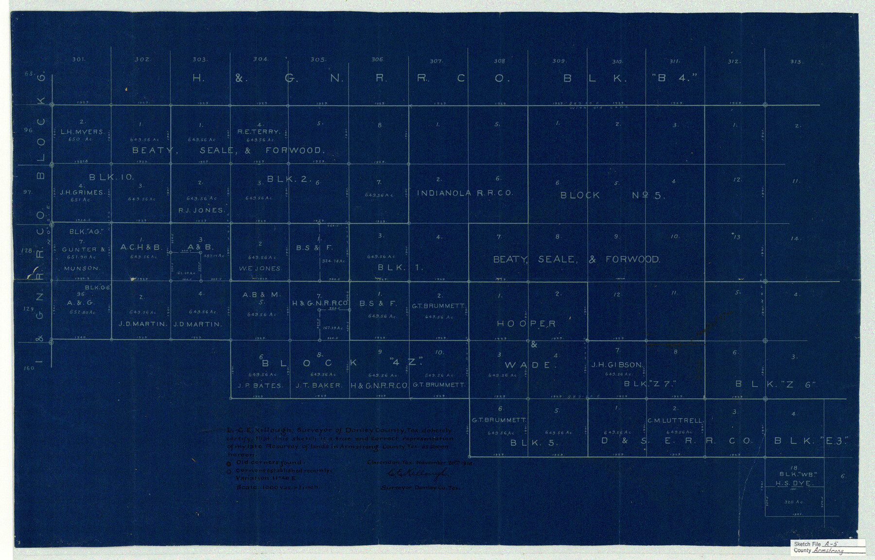
Armstrong County Sketch File A-5
[Sketch showing parts of Blocks 10 and 2, B. S. & F. and Blocks 4Z, Z6, 5, and E3]
- 
                          Map/Doc
10846
 - 
                            Collection
General Map Collection
 - 
                            Object Dates
1918/11/20 (Creation Date)
1919/1/18 (File Date)
 - 
                            People and Organizations
C.E. Killough (Surveyor/Engineer)
 - 
                            Counties
Armstrong
 - 
                            Subjects
Surveying Sketch File
 - 
                            Height x Width
18.0 x 28.2 inches
45.7 x 71.6 cm
 - 
                            Medium
blueprint/diazo
 - 
                            Scale
1" = 1000 varas
 
Part of: General Map Collection
            Map of the United States and their Territories between the Mississippi and the Pacific Ocean and part of Mexico


                                            Print $20.00                    
                                             -                         Digital $50.00                                    
                Map of the United States and their Territories between the Mississippi and the Pacific Ocean and part of Mexico
Size 23.5 x 26.5 inches
                                Map/Doc 96526
            
            Pecos County Rolled Sketch 174


                                            Print $20.00                    
                                             -                         Digital $50.00                                    
                Pecos County Rolled Sketch 174
Size 23.3 x 25.0 inches
                                Map/Doc 7294
            
            Young Territory


                                            Print $20.00                    
                                             -                         Digital $50.00                                    
                Young Territory
1873
Size 29.2 x 29.9 inches
                                Map/Doc 1976
            
            Trinity County Working Sketch 3


                                            Print $20.00                    
                                             -                         Digital $50.00                                    
                Trinity County Working Sketch 3
1905
Size 26.7 x 19.2 inches
                                Map/Doc 69451
            
            [Drawings of individual counties for Pressler and Langermann's 1879 Map of Texas]


                                            Print $20.00                    
                                             -                         Digital $50.00                                    
                [Drawings of individual counties for Pressler and Langermann's 1879 Map of Texas]
1878
Size 38.8 x 26.8 inches
                                Map/Doc 4863
            
            Nueces County Sketch File 7


                                            Print $7.00                    
                                             -                         Digital $50.00                                    
                Nueces County Sketch File 7
1849
Size 11.3 x 9.3 inches
                                Map/Doc 32509
            
            Jim Wells County Working Sketch 9


                                            Print $20.00                    
                                             -                         Digital $50.00                                    
                Jim Wells County Working Sketch 9
1948
Size 34.1 x 38.9 inches
                                Map/Doc 66607
            
            Flight Mission No. CGI-1N, Frame 134, Cameron County


                                            Print $20.00                    
                                             -                         Digital $50.00                                    
                Flight Mission No. CGI-1N, Frame 134, Cameron County
1955
Size 18.5 x 22.1 inches
                                Map/Doc 84490
            
            Lubbock County Working Sketch 4


                                            Print $20.00                    
                                             -                         Digital $50.00                                    
                Lubbock County Working Sketch 4
1947
Size 31.8 x 36.8 inches
                                Map/Doc 70664
            
            Floyd County Working Sketch 3


                                            Print $20.00                    
                                             -                         Digital $50.00                                    
                Floyd County Working Sketch 3
1948
Size 27.4 x 22.8 inches
                                Map/Doc 69182
            
            Lamb County Sketch File B


                                            Print $6.00                    
                                             -                         Digital $50.00                                    
                Lamb County Sketch File B
1902
Size 11.2 x 8.8 inches
                                Map/Doc 29344
            
            Flight Mission No. BRA-7M, Frame 39, Jefferson County


                                            Print $20.00                    
                                             -                         Digital $50.00                                    
                Flight Mission No. BRA-7M, Frame 39, Jefferson County
1953
Size 18.7 x 22.5 inches
                                Map/Doc 85490
            You may also like
            Flight Mission No. BRE-1P, Frame 71, Nueces County


                                            Print $20.00                    
                                             -                         Digital $50.00                                    
                Flight Mission No. BRE-1P, Frame 71, Nueces County
1956
Size 18.6 x 22.2 inches
                                Map/Doc 86653
            
            Red River County Working Sketch 71


                                            Print $4.00                    
                                             -                         Digital $50.00                                    
                Red River County Working Sketch 71
1977
Size 17.8 x 28.0 inches
                                Map/Doc 72054
            
            Nacogdoches County Sketch File 16


                                            Print $20.00                    
                                             -                         Digital $50.00                                    
                Nacogdoches County Sketch File 16
1945
Size 24.6 x 18.5 inches
                                Map/Doc 42155
            
            Crockett County Rolled Sketch 88E


                                            Print $40.00                    
                                             -                         Digital $50.00                                    
                Crockett County Rolled Sketch 88E
1973
Size 44.4 x 30.6 inches
                                Map/Doc 8730
            
            [Atchison, Topeka & Santa Fe from Paisano to south of Plata]


                                            Print $40.00                    
                                             -                         Digital $50.00                                    
                [Atchison, Topeka & Santa Fe from Paisano to south of Plata]
Size 32.2 x 116.3 inches
                                Map/Doc 64713
            
            Presidio County Working Sketch 48


                                            Print $20.00                    
                                             -                         Digital $50.00                                    
                Presidio County Working Sketch 48
1950
Size 36.2 x 31.0 inches
                                Map/Doc 71725
            
            Controlled Mosaic by Jack Amman Photogrammetric Engineers, Inc - Sheet 35


                                            Print $20.00                    
                                             -                         Digital $50.00                                    
                Controlled Mosaic by Jack Amman Photogrammetric Engineers, Inc - Sheet 35
1954
Size 20.0 x 24.0 inches
                                Map/Doc 83488
            
            Map of Wise County


                                            Print $20.00                    
                                             -                         Digital $50.00                                    
                Map of Wise County
1862
Size 23.5 x 19.0 inches
                                Map/Doc 4162
            
            Flight Mission No. DAG-18K, Frame 70, Matagorda County


                                            Print $20.00                    
                                             -                         Digital $50.00                                    
                Flight Mission No. DAG-18K, Frame 70, Matagorda County
1952
Size 16.3 x 16.2 inches
                                Map/Doc 86363
            
            Revised Sectional Map Number 2, Showing Land Surveys in Counties of Howard, Martin, Andrews, Glasscock, Midland, Ector, and Portions of Borden, Dawson, Irion, Reagan, Upton, Crane, Ward, and Winkler, Texas


                                            Print $20.00                    
                                             -                         Digital $50.00                                    
                Revised Sectional Map Number 2, Showing Land Surveys in Counties of Howard, Martin, Andrews, Glasscock, Midland, Ector, and Portions of Borden, Dawson, Irion, Reagan, Upton, Crane, Ward, and Winkler, Texas
Size 20.0 x 25.4 inches
                                Map/Doc 91358
            
            Potter County Boundary File 6a


                                            Print $20.00                    
                                             -                         Digital $50.00                                    
                Potter County Boundary File 6a
Size 43.8 x 15.6 inches
                                Map/Doc 58039