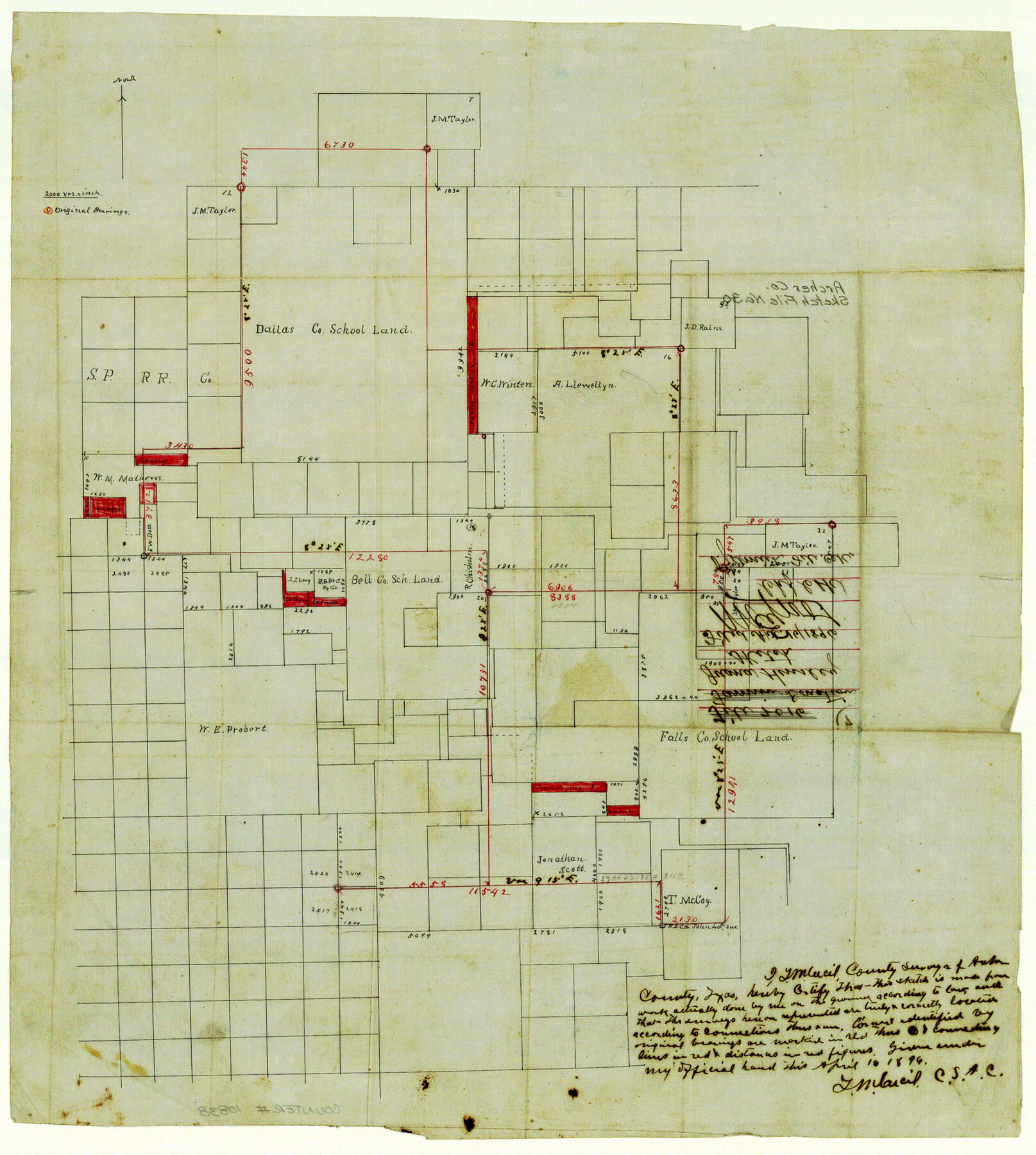
Archer County Sketch File 30
[Sketch of surveys around Bell County School Land southwest of Archer City]
-
Map/Doc
10838
-
Collection
General Map Collection
-
Object Dates
1896/4/16 (Creation Date)
-
People and Organizations
T.M. Cecil (Surveyor/Engineer)
-
Counties
Archer
-
Subjects
Surveying Sketch File
-
Height x Width
20.6 x 18.5 inches
52.3 x 47.0 cm
-
Medium
linen, manuscript
-
Scale
1" = 2000 varas
-
Comments
Sketch transferred from FAN B-2016.
Part of: General Map Collection
Ward County Working Sketch 48

Print $20.00
- Digital $50.00
Ward County Working Sketch 48
1974
Size 28.2 x 44.1 inches
Map/Doc 72354
Johnson County Sketch File 22

Print $20.00
- Digital $50.00
Johnson County Sketch File 22
1873
Size 18.8 x 16.2 inches
Map/Doc 11891
McMullen County Sketch File 11

Print $4.00
- Digital $50.00
McMullen County Sketch File 11
1876
Size 7.3 x 8.4 inches
Map/Doc 31355
Val Verde County Sketch File 51a

Print $8.00
- Digital $50.00
Val Verde County Sketch File 51a
1959
Size 11.4 x 8.8 inches
Map/Doc 39325
Harris County Working Sketch 18

Print $20.00
- Digital $50.00
Harris County Working Sketch 18
1919
Size 12.1 x 14.8 inches
Map/Doc 65910
Johnson County Working Sketch 12

Print $20.00
- Digital $50.00
Johnson County Working Sketch 12
1959
Size 22.9 x 22.6 inches
Map/Doc 66625
Newton County Sketch File 4b

Print $22.00
- Digital $50.00
Newton County Sketch File 4b
Size 7.6 x 12.2 inches
Map/Doc 32364
Flight Mission No. CRC-4R, Frame 185, Chambers County

Print $20.00
- Digital $50.00
Flight Mission No. CRC-4R, Frame 185, Chambers County
1956
Size 18.5 x 22.2 inches
Map/Doc 84936
Webb County Rolled Sketch 42

Print $20.00
- Digital $50.00
Webb County Rolled Sketch 42
1941
Size 25.2 x 37.1 inches
Map/Doc 8197
South Part Presidio County

Print $20.00
- Digital $50.00
South Part Presidio County
1975
Size 31.6 x 37.2 inches
Map/Doc 77400
Flight Mission No. DIX-8P, Frame 75, Aransas County

Print $20.00
- Digital $50.00
Flight Mission No. DIX-8P, Frame 75, Aransas County
1956
Size 18.9 x 22.3 inches
Map/Doc 83906
Refugio County Working Sketch 8

Print $40.00
- Digital $50.00
Refugio County Working Sketch 8
1940
Size 56.7 x 42.9 inches
Map/Doc 63517
You may also like
Irion County Sketch File 3

Print $20.00
- Digital $50.00
Irion County Sketch File 3
1891
Size 22.4 x 22.1 inches
Map/Doc 11823
Starr County Working Sketch 29

Print $20.00
- Digital $50.00
Starr County Working Sketch 29
2007
Size 28.6 x 34.0 inches
Map/Doc 87208
Copy of Surveyor's Field Book, Morris Browning - In Blocks 7, 5 & 4, I&GNRRCo., Hutchinson and Carson Counties, Texas

Print $2.00
- Digital $50.00
Copy of Surveyor's Field Book, Morris Browning - In Blocks 7, 5 & 4, I&GNRRCo., Hutchinson and Carson Counties, Texas
1888
Size 8.9 x 7.1 inches
Map/Doc 62287
Kinney County Sketch File 35

Print $6.00
- Digital $50.00
Kinney County Sketch File 35
1944
Size 14.2 x 8.7 inches
Map/Doc 29185
University Land Field Notes for Blocks 34 through 37 in Terrell County

University Land Field Notes for Blocks 34 through 37 in Terrell County
Map/Doc 81720
Map of Texas to accompany "Brady's Glimpses of Texas"

Print $20.00
- Digital $50.00
Map of Texas to accompany "Brady's Glimpses of Texas"
1871
Size 13.0 x 16.1 inches
Map/Doc 93907
General Highway Map. Detail of Cities and Towns in Dallas County, Texas [Dallas and vicinity]
![79069, General Highway Map. Detail of Cities and Towns in Dallas County, Texas [Dallas and vicinity], Texas State Library and Archives](https://historictexasmaps.com/wmedia_w700/maps/79069.tif.jpg)
Print $20.00
General Highway Map. Detail of Cities and Towns in Dallas County, Texas [Dallas and vicinity]
1936
Size 18.4 x 25.2 inches
Map/Doc 79069
[Blocks O, N, 34, B19, B29]
![92969, [Blocks O, N, 34, B19, B29], Twichell Survey Records](https://historictexasmaps.com/wmedia_w700/maps/92969-1.tif.jpg)
Print $20.00
- Digital $50.00
[Blocks O, N, 34, B19, B29]
Size 24.1 x 24.4 inches
Map/Doc 92969
Hopkins County Sketch File 2a

Print $4.00
- Digital $50.00
Hopkins County Sketch File 2a
Size 13.6 x 8.6 inches
Map/Doc 26683
San Jacinto County Working Sketch 33

Print $20.00
- Digital $50.00
San Jacinto County Working Sketch 33
1955
Size 25.4 x 31.8 inches
Map/Doc 63746
Cass County Rolled Sketch 3

Print $20.00
- Digital $50.00
Cass County Rolled Sketch 3
1937
Size 34.9 x 34.6 inches
Map/Doc 8585
Wichita County Sketch File 17

Print $20.00
- Digital $50.00
Wichita County Sketch File 17
1889
Size 29.7 x 22.4 inches
Map/Doc 12680