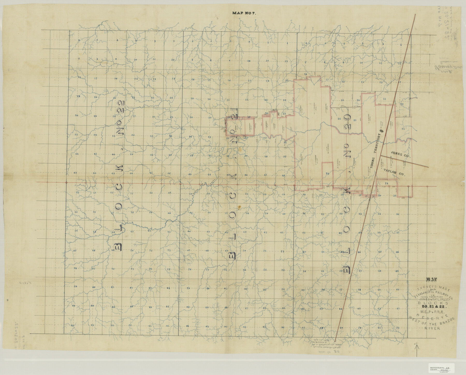
Nolan County Sketch File 1b
Map of surveys made for the Texas Pacific Railway Co. in Young Territory, Jones & Taylor Cos. Blocks 20, 21, & 22 M. El. P. & P. R.R. Reserve west of the Brazos River
-
Map/Doc
10555
-
Collection
General Map Collection
-
Object Dates
8/10/1875 (Creation Date)
-
Counties
Nolan Fisher
-
Subjects
Surveying Sketch File
-
Height x Width
37.6 x 46.7 inches
95.5 x 118.6 cm
-
Medium
paper, manuscript
-
Features
South Elm Creek
T&P
Brazos River
Part of: General Map Collection
Comanche County Boundary File 2a

Print $4.00
- Digital $50.00
Comanche County Boundary File 2a
Size 14.3 x 8.8 inches
Map/Doc 51788
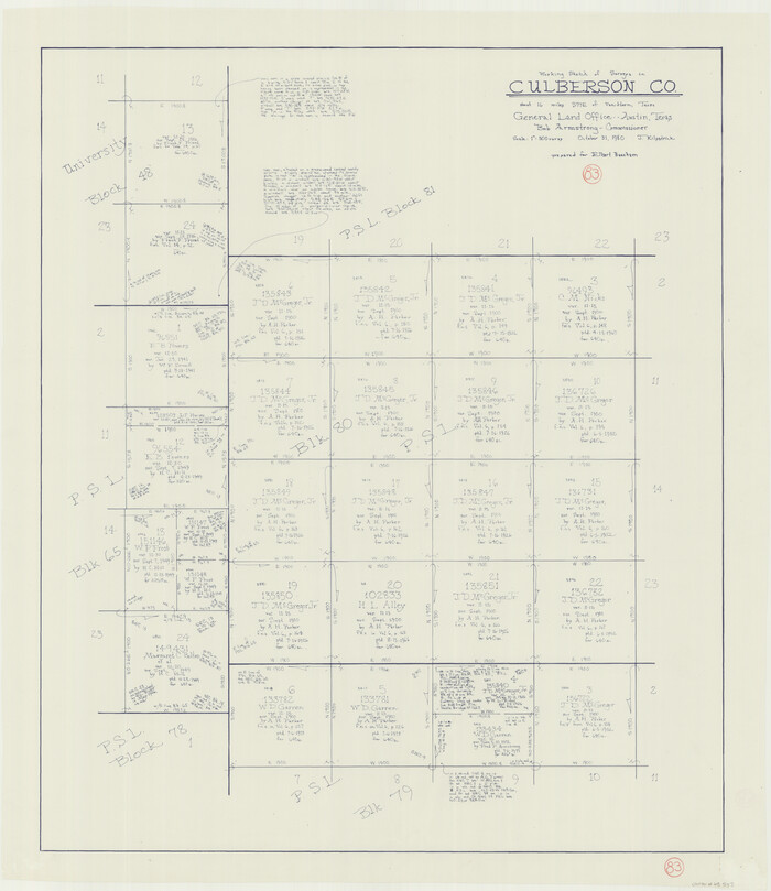
Culberson County Working Sketch 83
Print $20.00
- Digital $50.00
Culberson County Working Sketch 83
1980
Size 33.4 x 28.9 inches
Map/Doc 68537
Brazoria County NRC Article 33.136 Sketch 16

Print $72.00
- Digital $50.00
Brazoria County NRC Article 33.136 Sketch 16
2014
Size 22.0 x 36.0 inches
Map/Doc 95037
Baylor County Aerial Photograph Index Sheet 3

Print $20.00
- Digital $50.00
Baylor County Aerial Photograph Index Sheet 3
1950
Size 20.4 x 15.5 inches
Map/Doc 83665
Rusk County Working Sketch 10

Print $20.00
- Digital $50.00
Rusk County Working Sketch 10
1980
Size 22.4 x 20.6 inches
Map/Doc 63645
[Surveys in Austin's Colony along the Navidad River, Caney Fork, and upper Rocky Creek]
![201, [Surveys in Austin's Colony along the Navidad River, Caney Fork, and upper Rocky Creek], General Map Collection](https://historictexasmaps.com/wmedia_w700/maps/201-1.tif.jpg)
Print $20.00
- Digital $50.00
[Surveys in Austin's Colony along the Navidad River, Caney Fork, and upper Rocky Creek]
1831
Size 20.5 x 26.7 inches
Map/Doc 201
Irion County Working Sketch 1

Print $20.00
- Digital $50.00
Irion County Working Sketch 1
Size 24.3 x 26.8 inches
Map/Doc 66410
Galveston County Rolled Sketch 46

Print $40.00
- Digital $50.00
Galveston County Rolled Sketch 46
2000
Size 32.0 x 48.3 inches
Map/Doc 5981
Working Sketch No. IV in Pecos County

Print $20.00
- Digital $50.00
Working Sketch No. IV in Pecos County
1886
Size 36.7 x 23.6 inches
Map/Doc 3954
Val Verde County Sketch File B2

Print $20.00
- Digital $50.00
Val Verde County Sketch File B2
1910
Size 24.5 x 12.2 inches
Map/Doc 12544
Cooke County Sketch File 16-17-18

Print $16.00
- Digital $50.00
Cooke County Sketch File 16-17-18
1860
Size 12.7 x 8.1 inches
Map/Doc 19252
Webb County Working Sketch 87

Print $20.00
- Digital $50.00
Webb County Working Sketch 87
1981
Size 46.3 x 39.6 inches
Map/Doc 72454
You may also like
Kinney County Rolled Sketch 9

Print $20.00
- Digital $50.00
Kinney County Rolled Sketch 9
Size 39.4 x 27.5 inches
Map/Doc 6538
Sketch of 103rd Meridian, W. L. showing Conflict of Capitol Leagues

Print $20.00
- Digital $50.00
Sketch of 103rd Meridian, W. L. showing Conflict of Capitol Leagues
Size 8.1 x 22.1 inches
Map/Doc 90578
Navarro County Boundary File 1

Print $66.00
- Digital $50.00
Navarro County Boundary File 1
Size 10.3 x 8.2 inches
Map/Doc 57582
Tarrant County Boundary File 2a

Print $62.00
- Digital $50.00
Tarrant County Boundary File 2a
Size 9.0 x 4.8 inches
Map/Doc 59114
Sabine and Neches Rivers

Print $20.00
- Digital $50.00
Sabine and Neches Rivers
Size 19.6 x 43.7 inches
Map/Doc 94444
Hardin County Sketch File 46

Print $8.00
- Digital $50.00
Hardin County Sketch File 46
1875
Size 12.8 x 8.4 inches
Map/Doc 25196
Atascosa County Working Sketch 1b

Print $20.00
- Digital $50.00
Atascosa County Working Sketch 1b
1908
Size 36.2 x 39.0 inches
Map/Doc 67195
Flight Mission No. BRE-3P, Frame 38, Nueces County

Print $20.00
- Digital $50.00
Flight Mission No. BRE-3P, Frame 38, Nueces County
1956
Size 18.5 x 22.4 inches
Map/Doc 86816
Montague County Working Sketch 11

Print $20.00
- Digital $50.00
Montague County Working Sketch 11
1936
Size 33.8 x 21.3 inches
Map/Doc 71077
Atascosa County Boundary File 2

Print $52.00
- Digital $50.00
Atascosa County Boundary File 2
Size 8.9 x 36.2 inches
Map/Doc 50160
Rand McNally Standard Map of Texas

Print $20.00
- Digital $50.00
Rand McNally Standard Map of Texas
1926
Size 27.3 x 39.9 inches
Map/Doc 95855
Sutton County Working Sketch 15

Print $40.00
- Digital $50.00
Sutton County Working Sketch 15
1972
Size 37.0 x 81.1 inches
Map/Doc 62358