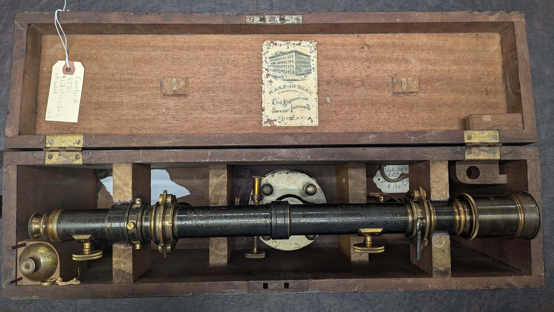
Gurley 20" Wye Level
Manufacturer: Gurley Engineering Instruments Case: Wooden Box Manufacture Location: Troy, NY
-
Map/Doc
97301
-
Collection
Equipment and Tools
-
Object Dates
ca. 1880 - 1890 (Manufacture Date)
-
People and Organizations
W. & L. E. Gurley (Manufacturer)
-
Height x Width
9.5 x 22.3 inches
24.1 x 56.5 cm
Part of: Equipment and Tools

Wooden Arrow with metal arrowhead

Wooden Arrow with metal arrowhead
Size 31.5 x 0.0 inches
Map/Doc 97334


K&E Paragon N4238 Compensating Polar Planimeter

K&E Paragon N4238 Compensating Polar Planimeter
1930
Size 1.5 x 9.3 inches
Map/Doc 97308
Dietzgen "Federal" 986 Proportional Divider Drafting Tool

Dietzgen "Federal" 986 Proportional Divider Drafting Tool
Size 1.0 x 8.3 inches
Map/Doc 97307

You may also like
Flight Mission No. DAH-9M, Frame 201, Orange County

Print $20.00
- Digital $50.00
Flight Mission No. DAH-9M, Frame 201, Orange County
1953
Size 18.6 x 22.5 inches
Map/Doc 86869
Coast Chart No. 210 Aransas Pass and Corpus Christi Bay with the coast to latitude 27° 12' Texas

Print $20.00
- Digital $50.00
Coast Chart No. 210 Aransas Pass and Corpus Christi Bay with the coast to latitude 27° 12' Texas
1913
Size 27.7 x 18.3 inches
Map/Doc 72798
Kimble County Working Sketch 97

Print $20.00
- Digital $50.00
Kimble County Working Sketch 97
2012
Size 42.8 x 36.6 inches
Map/Doc 93388
[Section 2, Block 5, Dawson County, Texas]
![92617, [Section 2, Block 5, Dawson County, Texas], Twichell Survey Records](https://historictexasmaps.com/wmedia_w700/maps/92617-1.tif.jpg)
Print $2.00
- Digital $50.00
[Section 2, Block 5, Dawson County, Texas]
Size 9.2 x 12.3 inches
Map/Doc 92617
Map of Ramsey State Farm, Brazoria County, Texas

Print $20.00
- Digital $50.00
Map of Ramsey State Farm, Brazoria County, Texas
Size 29.0 x 37.1 inches
Map/Doc 62997
Galveston County Sketch File 69

Print $226.00
- Digital $50.00
Galveston County Sketch File 69
1884
Size 14.4 x 9.0 inches
Map/Doc 23815
Refugio County NRC Article 33.136 Sketch 2

Print $26.00
- Digital $50.00
Refugio County NRC Article 33.136 Sketch 2
2003
Size 24.5 x 36.5 inches
Map/Doc 78536
Goliad County Sketch File 22

Print $12.00
- Digital $50.00
Goliad County Sketch File 22
1855
Size 12.8 x 8.1 inches
Map/Doc 24289
Orange County Working Sketch 13

Print $20.00
- Digital $50.00
Orange County Working Sketch 13
1922
Size 12.9 x 15.5 inches
Map/Doc 71345
Map of Fisher and Miller's Colony made from the records in the Office of the District Surveyor of Bexar comprising also all the recent surveys

Print $20.00
- Digital $50.00
Map of Fisher and Miller's Colony made from the records in the Office of the District Surveyor of Bexar comprising also all the recent surveys
1855
Size 27.2 x 39.6 inches
Map/Doc 82026
Flight Mission No. BRA-16M, Frame 95, Jefferson County

Print $20.00
- Digital $50.00
Flight Mission No. BRA-16M, Frame 95, Jefferson County
1953
Size 18.5 x 22.2 inches
Map/Doc 85707
Fannin County Rolled Sketch 18D

Print $2.00
- Digital $50.00
Fannin County Rolled Sketch 18D
Size 12.9 x 8.1 inches
Map/Doc 5871