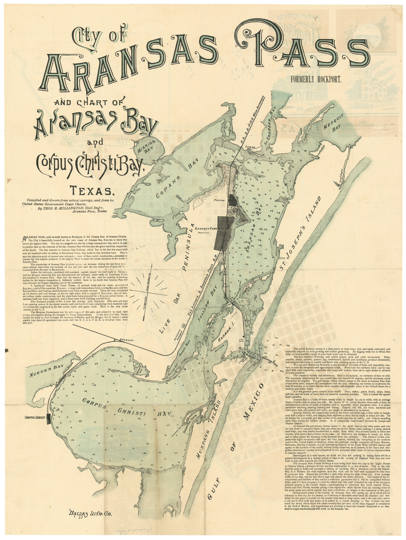
City of Aransas Pass and Chart of Aransas Bay and Corpus Christi Bay, Texas
-
Map/Doc
97265
-
Collection
General Map Collection
-
Object Dates
[1905] (Creation Date)
-
People and Organizations
Thos. H. Millington (Surveyor/Engineer)
-
Counties
Aransas
-
Subjects
City Coastal
-
Height x Width
28.4 x 21.4 inches
72.1 x 54.4 cm
-
Comments
See 97266 for map on verso.
Related maps
Map of the City of Aransas Pass

Print $20.00
- Digital $50.00
Map of the City of Aransas Pass
1905
Size 28.3 x 21.4 inches
Map/Doc 97266
Part of: General Map Collection
Concho County Sketch File 1

Print $5.00
- Digital $50.00
Concho County Sketch File 1
1856
Size 5.0 x 6.6 inches
Map/Doc 19121
Blanco County Working Sketch 6

Print $20.00
- Digital $50.00
Blanco County Working Sketch 6
1923
Size 17.6 x 12.5 inches
Map/Doc 67365
Flight Mission No. DCL-6C, Frame 132, Kenedy County

Print $20.00
- Digital $50.00
Flight Mission No. DCL-6C, Frame 132, Kenedy County
1943
Size 18.6 x 22.3 inches
Map/Doc 85962
Angelina County Sketch File 28a

Print $14.00
- Digital $50.00
Angelina County Sketch File 28a
1910
Size 6.8 x 8.7 inches
Map/Doc 13080
Kinney County Rolled Sketch 13

Print $20.00
- Digital $50.00
Kinney County Rolled Sketch 13
1949
Size 24.9 x 37.4 inches
Map/Doc 77562

Duval County Rolled Sketch 13

Print $20.00
- Digital $50.00
Duval County Rolled Sketch 13
1937
Size 33.8 x 30.4 inches
Map/Doc 5735
St. Louis Southwestern Railway of Texas

Print $20.00
- Digital $50.00
St. Louis Southwestern Railway of Texas
1906
Size 21.7 x 30.0 inches
Map/Doc 64452
Hemphill County Sketch File 2

Print $8.00
- Digital $50.00
Hemphill County Sketch File 2
1900
Size 10.3 x 8.4 inches
Map/Doc 26281
Flight Mission No. DCL-5C, Frame 48, Kenedy County

Print $20.00
- Digital $50.00
Flight Mission No. DCL-5C, Frame 48, Kenedy County
1943
Size 18.6 x 22.2 inches
Map/Doc 85844
Maps & Lists Showing Prison Lands (Oil & Gas) Leased as of June 1955

Digital $50.00
Maps & Lists Showing Prison Lands (Oil & Gas) Leased as of June 1955
1934
Size 35.6 x 32.3 inches
Map/Doc 62879
Bell County Sketch File 27

Print $4.00
- Digital $50.00
Bell County Sketch File 27
1870
Size 8.9 x 9.4 inches
Map/Doc 14435
You may also like
Hudspeth County Working Sketch 4

Print $20.00
- Digital $50.00
Hudspeth County Working Sketch 4
1914
Size 16.9 x 20.5 inches
Map/Doc 66285
Leon County Working Sketch 13

Print $20.00
- Digital $50.00
Leon County Working Sketch 13
1956
Size 23.0 x 22.7 inches
Map/Doc 70412
[Northeast Portion of Moore County]
![91517, [Northeast Portion of Moore County], Twichell Survey Records](https://historictexasmaps.com/wmedia_w700/maps/91517-1.tif.jpg)
Print $20.00
- Digital $50.00
[Northeast Portion of Moore County]
Size 31.7 x 8.5 inches
Map/Doc 91517
[Galveston, Harrisburg & San Antonio Railroad from Cuero to Stockdale]
![64192, [Galveston, Harrisburg & San Antonio Railroad from Cuero to Stockdale], General Map Collection](https://historictexasmaps.com/wmedia_w700/maps/64192.tif.jpg)
Print $20.00
- Digital $50.00
[Galveston, Harrisburg & San Antonio Railroad from Cuero to Stockdale]
1907
Size 14.1 x 34.1 inches
Map/Doc 64192
St. L. S-W. Ry. of Texas Map of Lufkin Branch in Angelina County, Texas

Print $20.00
- Digital $50.00
St. L. S-W. Ry. of Texas Map of Lufkin Branch in Angelina County, Texas
1913
Size 24.0 x 12.1 inches
Map/Doc 64562
Flight Mission No. CUG-3P, Frame 159, Kleberg County

Print $20.00
- Digital $50.00
Flight Mission No. CUG-3P, Frame 159, Kleberg County
1956
Size 18.7 x 22.3 inches
Map/Doc 86279
Matagorda County Working Sketch 17

Print $20.00
- Digital $50.00
Matagorda County Working Sketch 17
1961
Size 31.2 x 42.2 inches
Map/Doc 70875
Chart of the World shewing the tracks of the U.S. Exploring Expedition in 1833, 39, 40, 41 & 42

Print $20.00
- Digital $50.00
Chart of the World shewing the tracks of the U.S. Exploring Expedition in 1833, 39, 40, 41 & 42
1842
Size 26.3 x 37.4 inches
Map/Doc 94057
Map of the N. Orleans, Mobile and Texas Railroad and Connections

Print $20.00
- Digital $50.00
Map of the N. Orleans, Mobile and Texas Railroad and Connections
1871
Size 8.9 x 11.1 inches
Map/Doc 96611
Marion County Working Sketch 12

Print $20.00
- Digital $50.00
Marion County Working Sketch 12
1952
Size 24.5 x 34.2 inches
Map/Doc 70787
San Antonio of the 17th, 18th, and 19th Centuries: A Chronology of Her Romantic Past

San Antonio of the 17th, 18th, and 19th Centuries: A Chronology of Her Romantic Past
1929
Size 8.1 x 5.1 inches
Map/Doc 97044
Lavaca County Working Sketch 20

Print $20.00
- Digital $50.00
Lavaca County Working Sketch 20
1980
Size 19.2 x 26.0 inches
Map/Doc 70373