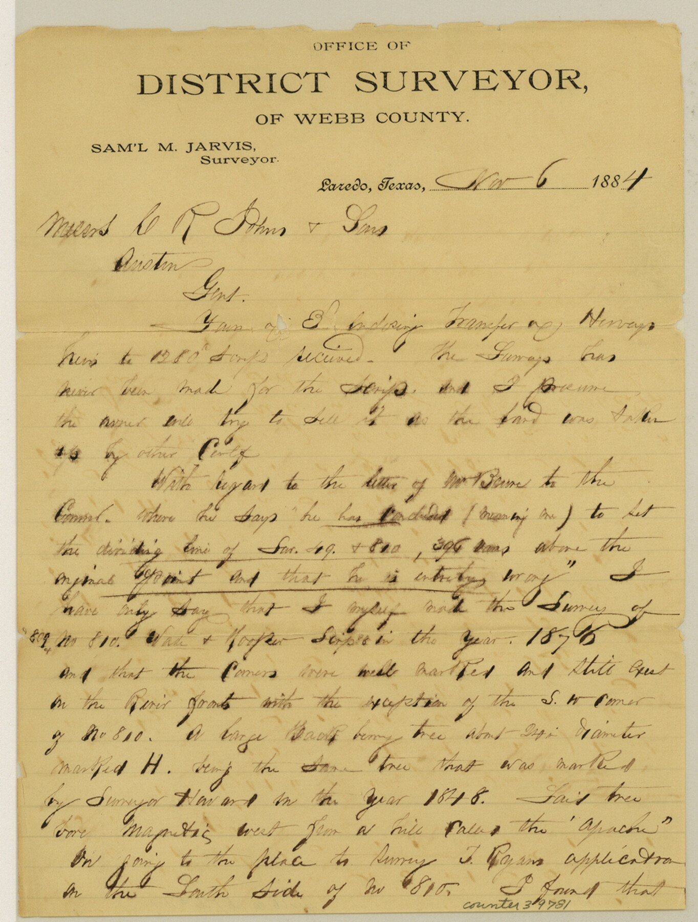
Webb County Sketch File 11-1
[Surveyor's statement relating to Brune's protest of surveys 809 and 810]
-
Map/Doc
39781
-
Collection
General Map Collection
-
Object Dates
11/6/1884 (Creation Date)
11/10/1884 (File Date)
-
People and Organizations
Samuel M. Jarvis (Surveyor/Engineer)
-
Counties
Webb
-
Subjects
Surveying Sketch File
-
Height x Width
11.3 x 8.5 inches
28.7 x 21.6 cm
-
Medium
paper, manuscript
-
Features
Apache Hill
Part of: General Map Collection
Lee County Sketch File 4

Print $4.00
- Digital $50.00
Lee County Sketch File 4
1859
Size 9.5 x 8.1 inches
Map/Doc 29682
Bosque County Sketch File 26

Print $4.00
- Digital $50.00
Bosque County Sketch File 26
1868
Size 8.1 x 7.5 inches
Map/Doc 14811
Harris County NRC Article 33.136 Sketch 11

Print $28.00
- Digital $50.00
Harris County NRC Article 33.136 Sketch 11
2007
Size 24.0 x 36.0 inches
Map/Doc 94658
Culberson County Rolled Sketch 44

Print $20.00
- Digital $50.00
Culberson County Rolled Sketch 44
1949
Size 24.4 x 31.1 inches
Map/Doc 5666
Loving County Working Sketch 6

Print $40.00
- Digital $50.00
Loving County Working Sketch 6
1947
Size 31.3 x 51.0 inches
Map/Doc 70638
Stonewall County Rolled Sketch 7

Print $20.00
- Digital $50.00
Stonewall County Rolled Sketch 7
1890
Size 16.6 x 37.9 inches
Map/Doc 7864
Upton County Rolled Sketch 46

Print $20.00
- Digital $50.00
Upton County Rolled Sketch 46
1955
Size 22.5 x 35.0 inches
Map/Doc 8082
Bee County Sketch File 21

Print $40.00
- Digital $50.00
Bee County Sketch File 21
Size 12.8 x 15.4 inches
Map/Doc 14312
Edwards County Rolled Sketch 30

Print $20.00
- Digital $50.00
Edwards County Rolled Sketch 30
1980
Size 31.6 x 44.0 inches
Map/Doc 8848
Political Essay on the Kingdom of New Spain Vol. 4

Political Essay on the Kingdom of New Spain Vol. 4
1822
Map/Doc 97389
Kenedy County Rolled Sketch 4

Print $40.00
- Digital $50.00
Kenedy County Rolled Sketch 4
1904
Size 39.4 x 57.6 inches
Map/Doc 10654
Flight Mission No. DQN-7K, Frame 12, Calhoun County

Print $20.00
- Digital $50.00
Flight Mission No. DQN-7K, Frame 12, Calhoun County
1953
Size 18.6 x 22.2 inches
Map/Doc 84463
You may also like
Pecos County Sketch File 109

Print $5.00
- Digital $50.00
Pecos County Sketch File 109
1982
Size 14.8 x 9.3 inches
Map/Doc 34039
Hardeman County Sketch File 16

Print $20.00
- Digital $50.00
Hardeman County Sketch File 16
Size 21.9 x 26.8 inches
Map/Doc 11628
Mapa de los Estados Unidos de Méjico, Segun lo organizado y definido por las varias actas del Congreso de dicha Republica: y construido por las mejores autoridades

Print $20.00
- Digital $50.00
Mapa de los Estados Unidos de Méjico, Segun lo organizado y definido por las varias actas del Congreso de dicha Republica: y construido por las mejores autoridades
1828
Size 29.1 x 41.6 inches
Map/Doc 93846
[Brown County]
![3337, [Brown County], General Map Collection](https://historictexasmaps.com/wmedia_w700/maps/3337-1.tif.jpg)
Print $20.00
- Digital $50.00
[Brown County]
1863
Size 25.4 x 22.5 inches
Map/Doc 3337
[Block W, A4, & Part of CL, East Line Sabine County School Land]
![90699, [Block W, A4, & Part of CL, East Line Sabine County School Land], Twichell Survey Records](https://historictexasmaps.com/wmedia_w700/maps/90699-1.tif.jpg)
Print $20.00
- Digital $50.00
[Block W, A4, & Part of CL, East Line Sabine County School Land]
Size 27.5 x 16.6 inches
Map/Doc 90699
[T. & P. Block 35, Townships 4N and 5N]
![90574, [T. & P. Block 35, Townships 4N and 5N], Twichell Survey Records](https://historictexasmaps.com/wmedia_w700/maps/90574-1.tif.jpg)
Print $20.00
- Digital $50.00
[T. & P. Block 35, Townships 4N and 5N]
1907
Size 29.8 x 34.7 inches
Map/Doc 90574
County Map of the State of Texas Showing also portions of the Adjoining States and Territories (Inset: Plan of Galveston and Vicinity)

Print $20.00
- Digital $50.00
County Map of the State of Texas Showing also portions of the Adjoining States and Territories (Inset: Plan of Galveston and Vicinity)
1873
Size 15.5 x 23.1 inches
Map/Doc 93696
Trinity River, McKinney Sheet/East Fork of Trinity River

Print $20.00
- Digital $50.00
Trinity River, McKinney Sheet/East Fork of Trinity River
1931
Size 40.6 x 28.0 inches
Map/Doc 65241
[Surveys along the Frio River at the confluence of the Sabinal River]
![78372, [Surveys along the Frio River at the confluence of the Sabinal River], General Map Collection](https://historictexasmaps.com/wmedia_w700/maps/78372.tif.jpg)
Print $2.00
- Digital $50.00
[Surveys along the Frio River at the confluence of the Sabinal River]
1845
Size 6.2 x 8.9 inches
Map/Doc 78372
Fractional Township No. 7 South Range No. 16 East of the Indian Meridian, Indian Territory

Print $20.00
- Digital $50.00
Fractional Township No. 7 South Range No. 16 East of the Indian Meridian, Indian Territory
1897
Size 19.2 x 24.2 inches
Map/Doc 75229
[North Line of Kent County/South Line of Dickens County]
![90937, [North Line of Kent County/South Line of Dickens County], Twichell Survey Records](https://historictexasmaps.com/wmedia_w700/maps/90937-1.tif.jpg)
Print $20.00
- Digital $50.00
[North Line of Kent County/South Line of Dickens County]
1892
Size 8.4 x 38.1 inches
Map/Doc 90937
Subdivision of Alexander Ranch, Cochran County, Texas

Print $20.00
- Digital $50.00
Subdivision of Alexander Ranch, Cochran County, Texas
Size 15.4 x 29.8 inches
Map/Doc 92496