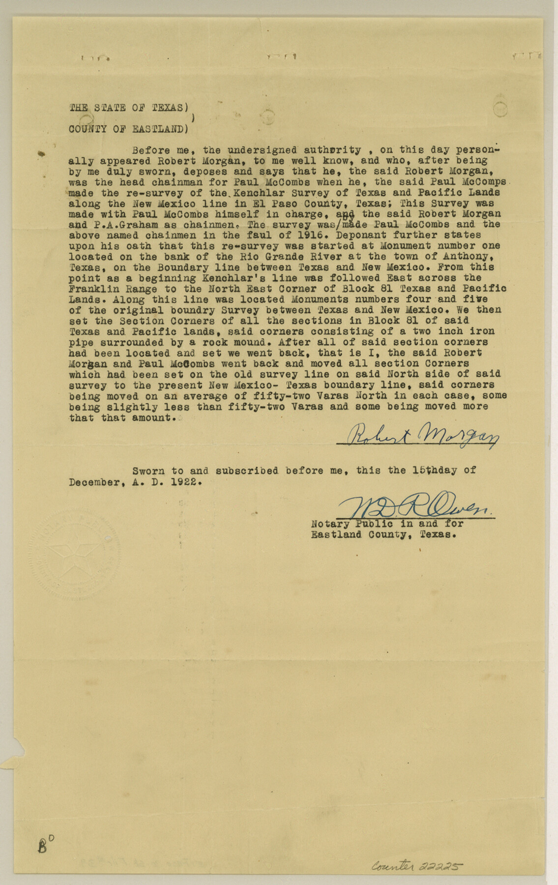
El Paso County Sketch File 39
[Affidavits regarding surveys 3, 91, 174, 252, etc]
-
Map/Doc
22225
-
Collection
General Map Collection
-
Object Dates
1922/11/23 (Creation Date)
1922 (File Date)
1916 (Survey Date)
1922/12/16 (Survey Date)
1859 (Survey Date)
-
People and Organizations
W.L. Rider (Surveyor/Engineer)
Paul McCombs (Surveyor/Engineer)
Robert Morgan (Chainman)
P.A. Graham (Chainman)
Kenchlar (Surveyor/Engineer)
Carter (Surveyor/Engineer)
J.H. Clark (Surveyor/Engineer)
Jacob Kuechler (Surveyor/Engineer)
-
Counties
El Paso Hudspeth
-
Subjects
Surveying Sketch File
-
Height x Width
13.9 x 8.8 inches
35.3 x 22.4 cm
-
Medium
paper, print
-
Features
Rio Grande
Anthony
El Paso-Santa Cruz Road
Franklin Mountains
Hueco Mountains
El Paso, Rio Grande & Santa Fe RR
Upper Valley Road
El Paso
Courchesne Bridge
White Spur Station
Fort Handcock [sic]
Vinton
Part of: General Map Collection
Shackelford County Sketch File 4

Print $40.00
- Digital $50.00
Shackelford County Sketch File 4
Size 38.5 x 53.7 inches
Map/Doc 10600
Kimble County Sketch File L1

Print $22.00
- Digital $50.00
Kimble County Sketch File L1
Size 7.1 x 13.1 inches
Map/Doc 28967
Jones County Sketch File 11

Print $6.00
- Digital $50.00
Jones County Sketch File 11
1875
Size 11.1 x 8.7 inches
Map/Doc 28496
Bosque County

Print $40.00
- Digital $50.00
Bosque County
1945
Size 48.8 x 38.7 inches
Map/Doc 95432
Brewster County Sketch File NS-4b

Print $40.00
- Digital $50.00
Brewster County Sketch File NS-4b
Size 30.4 x 35.8 inches
Map/Doc 10988
Calhoun County Rolled Sketch 27

Print $127.00
- Digital $50.00
Calhoun County Rolled Sketch 27
1976
Size 10.1 x 16.0 inches
Map/Doc 43621
Lipscomb County Boundary File 8

Print $4.00
- Digital $50.00
Lipscomb County Boundary File 8
Size 11.1 x 8.6 inches
Map/Doc 56333
Mills County Boundary File 1

Print $28.00
- Digital $50.00
Mills County Boundary File 1
Size 8.3 x 8.0 inches
Map/Doc 57259
Hockley County

Print $20.00
- Digital $50.00
Hockley County
1914
Size 25.9 x 23.1 inches
Map/Doc 4980
Mills County Working Sketch 21

Print $20.00
- Digital $50.00
Mills County Working Sketch 21
1981
Size 33.6 x 37.6 inches
Map/Doc 71051
Culberson County Working Sketch 31

Print $20.00
- Digital $50.00
Culberson County Working Sketch 31
1958
Size 30.5 x 30.0 inches
Map/Doc 68484
[Map of Denton County]
![4529, [Map of Denton County], General Map Collection](https://historictexasmaps.com/wmedia_w700/maps/4529-1.tif.jpg)
Print $20.00
- Digital $50.00
[Map of Denton County]
1853
Size 24.5 x 29.1 inches
Map/Doc 4529
You may also like
Bexar County Sketch File 37

Print $5.00
- Digital $50.00
Bexar County Sketch File 37
1861
Size 16.2 x 8.2 inches
Map/Doc 14512
Matagorda County NRC Article 33.136 Sketch 18

Print $24.00
Matagorda County NRC Article 33.136 Sketch 18
2023
Map/Doc 97283
General Highway Map. Detail of Cities and Towns in Dallas County, Texas [Dallas and vicinity]
![79431, General Highway Map. Detail of Cities and Towns in Dallas County, Texas [Dallas and vicinity], Texas State Library and Archives](https://historictexasmaps.com/wmedia_w700/maps/79431.tif.jpg)
Print $20.00
General Highway Map. Detail of Cities and Towns in Dallas County, Texas [Dallas and vicinity]
1961
Size 18.1 x 24.4 inches
Map/Doc 79431
Nueces County Aerial Photograph Index Sheet 5

Print $20.00
- Digital $50.00
Nueces County Aerial Photograph Index Sheet 5
1956
Size 19.5 x 23.4 inches
Map/Doc 83738
Robertson County Working Sketch 7

Print $20.00
- Digital $50.00
Robertson County Working Sketch 7
1983
Size 36.6 x 38.3 inches
Map/Doc 78228

United States - Gulf Coast - Galveston to Rio Grande

Print $20.00
- Digital $50.00
United States - Gulf Coast - Galveston to Rio Grande
1941
Size 27.0 x 18.2 inches
Map/Doc 72754
Crockett County Rolled Sketch 77

Print $20.00
- Digital $50.00
Crockett County Rolled Sketch 77
1952
Size 26.9 x 28.6 inches
Map/Doc 5618
Terrell County Working Sketch 79

Print $40.00
- Digital $50.00
Terrell County Working Sketch 79
1983
Size 43.0 x 55.8 inches
Map/Doc 69600
McLennan County Sketch File 43

Print $4.00
- Digital $50.00
McLennan County Sketch File 43
1873
Size 10.0 x 8.1 inches
Map/Doc 31333
North Half of Val Verde Co., Tex.

Print $40.00
- Digital $50.00
North Half of Val Verde Co., Tex.
1948
Size 66.0 x 43.1 inches
Map/Doc 89809
Map of Chambers Co.

Print $20.00
- Digital $50.00
Map of Chambers Co.
1901
Size 24.9 x 25.1 inches
Map/Doc 4907