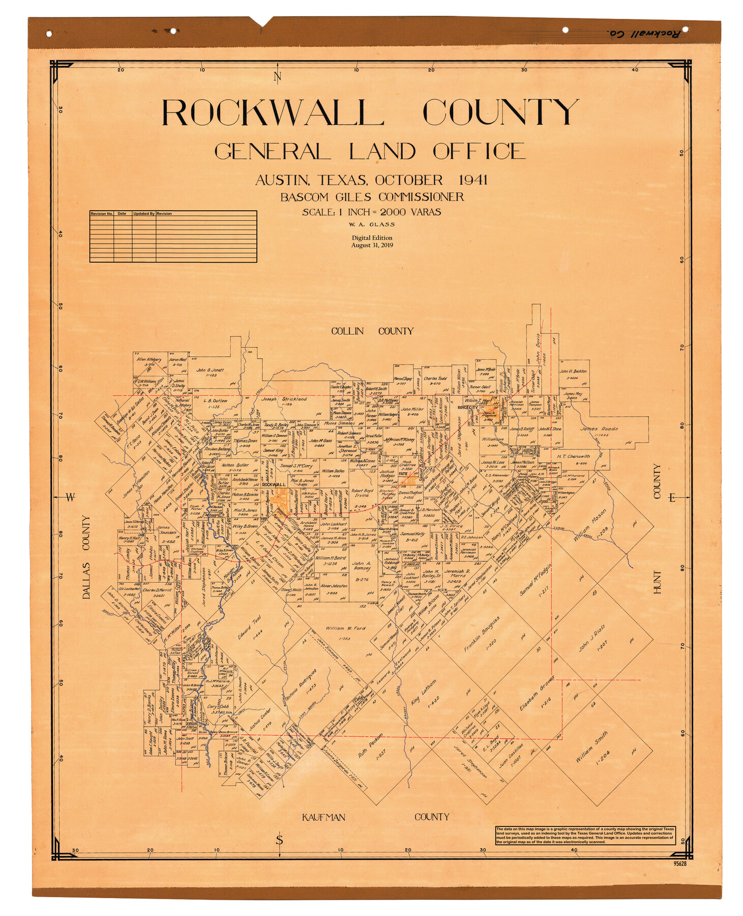
Rockwall County
General Land Office Official County Map
-
Map/Doc
95628
-
Collection
General Map Collection
-
Object Dates
2019/8/31 (Revision Date)
1941 (Creation Date)
-
People and Organizations
Cheyenne Betancourt (Draftsman)
W.A. Glass (Draftsman)
Bascom Giles (GLO Commissioner)
-
Counties
Rockwall
-
Subjects
County OCM
-
Height x Width
29.7 x 24.1 inches
75.4 x 61.2 cm
-
Medium
digital image
-
Scale
1" = 2000 varas
Part of: General Map Collection
Kendall County Working Sketch 26

Print $20.00
- Digital $50.00
Kendall County Working Sketch 26
1985
Size 42.5 x 36.0 inches
Map/Doc 66698
Flight Mission No. DIX-8P, Frame 71, Aransas County

Print $20.00
- Digital $50.00
Flight Mission No. DIX-8P, Frame 71, Aransas County
1956
Size 18.8 x 22.4 inches
Map/Doc 83902

Starr County Working Sketch 17

Print $20.00
- Digital $50.00
Starr County Working Sketch 17
1982
Size 46.1 x 42.7 inches
Map/Doc 63933
Irion County Boundary File 1a

Print $40.00
- Digital $50.00
Irion County Boundary File 1a
Size 33.5 x 9.3 inches
Map/Doc 55325
Randall County Rolled Sketch 9B

Print $20.00
- Digital $50.00
Randall County Rolled Sketch 9B
1985
Size 45.0 x 34.5 inches
Map/Doc 9810
Upton County Working Sketch 36

Print $40.00
- Digital $50.00
Upton County Working Sketch 36
1957
Size 43.5 x 57.3 inches
Map/Doc 69532
Flight Mission No. DCL-7C, Frame 42, Kenedy County

Print $20.00
- Digital $50.00
Flight Mission No. DCL-7C, Frame 42, Kenedy County
1943
Size 15.3 x 15.2 inches
Map/Doc 86030
Flight Mission No. DQN-5K, Frame 78, Calhoun County

Print $20.00
- Digital $50.00
Flight Mission No. DQN-5K, Frame 78, Calhoun County
1953
Size 18.6 x 22.3 inches
Map/Doc 84411
Armstrong County Working Sketch Graphic Index

Print $20.00
- Digital $50.00
Armstrong County Working Sketch Graphic Index
1933
Size 40.3 x 40.0 inches
Map/Doc 76457
Hunt County Rolled Sketch 5

Print $20.00
- Digital $50.00
Hunt County Rolled Sketch 5
1956
Size 27.6 x 24.8 inches
Map/Doc 6270
Blanco County Sketch File 20

Print $4.00
- Digital $50.00
Blanco County Sketch File 20
1879
Size 8.7 x 6.9 inches
Map/Doc 14598
You may also like
Flight Mission No. CGI-3N, Frame 182, Cameron County

Print $20.00
- Digital $50.00
Flight Mission No. CGI-3N, Frame 182, Cameron County
1954
Size 18.7 x 22.3 inches
Map/Doc 84646
Haskell County Working Sketch 2

Print $3.00
- Digital $50.00
Haskell County Working Sketch 2
1914
Size 14.9 x 10.1 inches
Map/Doc 66060
Angelina County Sketch File 15f

Print $4.00
- Digital $50.00
Angelina County Sketch File 15f
Size 10.4 x 7.6 inches
Map/Doc 12994
Translations of Titles - Austin's Second Contract, Vol. 3

Translations of Titles - Austin's Second Contract, Vol. 3
1841
Map/Doc 94548
Roberts County Working Sketch 20

Print $20.00
- Digital $50.00
Roberts County Working Sketch 20
1977
Size 25.6 x 32.9 inches
Map/Doc 63546
[Sketch showing San Augustine, Morris, Stephens and Eastland School Land Leagues and adjacent Blocks]
![89918, [Sketch showing San Augustine, Morris, Stephens and Eastland School Land Leagues and adjacent Blocks], Twichell Survey Records](https://historictexasmaps.com/wmedia_w700/maps/89918-1.tif.jpg)
Print $40.00
- Digital $50.00
[Sketch showing San Augustine, Morris, Stephens and Eastland School Land Leagues and adjacent Blocks]
Size 54.7 x 43.5 inches
Map/Doc 89918
Harris County Rolled Sketch 77

Print $20.00
- Digital $50.00
Harris County Rolled Sketch 77
1914
Size 30.0 x 35.6 inches
Map/Doc 6114
Flight Mission No. DCL-6C, Frame 98, Kenedy County

Print $20.00
- Digital $50.00
Flight Mission No. DCL-6C, Frame 98, Kenedy County
1943
Size 18.6 x 22.3 inches
Map/Doc 85928
Brooks County Working Sketch 9

Print $20.00
- Digital $50.00
Brooks County Working Sketch 9
1931
Size 25.7 x 38.7 inches
Map/Doc 67793
Liberty County Sketch File 54

Print $54.00
- Digital $50.00
Liberty County Sketch File 54
1889
Size 14.3 x 8.7 inches
Map/Doc 30022
Flight Mission No. BRA-16M, Frame 86, Jefferson County

Print $20.00
- Digital $50.00
Flight Mission No. BRA-16M, Frame 86, Jefferson County
1953
Size 18.5 x 22.3 inches
Map/Doc 85698
Plat of Resurvey of Sections 5, 7 and 8, T. 5S., R. 14W. Indian Meridian, Oklahoma

Print $4.00
- Digital $50.00
Plat of Resurvey of Sections 5, 7 and 8, T. 5S., R. 14W. Indian Meridian, Oklahoma
1917
Size 18.5 x 22.6 inches
Map/Doc 75140