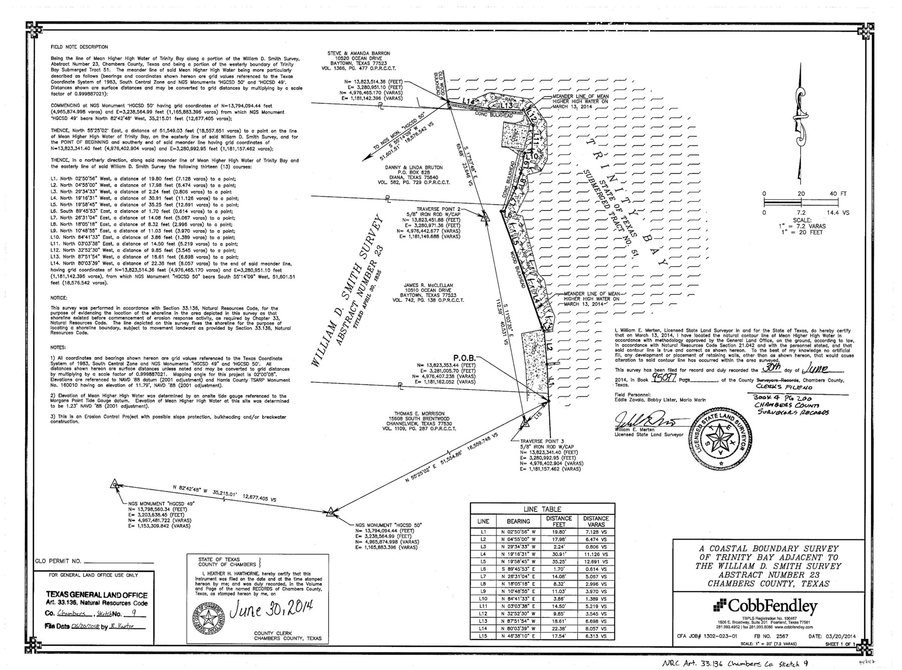
Chambers County NRC Article 33.136 Sketch 9
A coastal boundary survey of Trinity Bay adjacent to the William D. Smith survey abstract number 23
-
Map/Doc
94747
-
Collection
General Map Collection
-
Object Dates
2014/3/20 (Creation Date)
2018/6/20 (File Date)
-
People and Organizations
William E. Merten (Surveyor/Engineer)
-
Counties
Chambers
-
Subjects
Surveying CBS
-
Height x Width
17.7 x 24.0 inches
45.0 x 61.0 cm
-
Medium
multi-page, multi-format
-
Scale
1" = 20 feet = 7.2 varas
-
Comments
Project: Trinity Bay - McClellan Breakwater Project No.: SL20140014
Part of: General Map Collection
Matagorda County NRC Article 33.136 Sketch 8

Print $30.00
- Digital $50.00
Matagorda County NRC Article 33.136 Sketch 8
2011
Size 24.0 x 36.0 inches
Map/Doc 94621
Flight Mission No. DAG-19K, Frame 57, Matagorda County

Print $20.00
- Digital $50.00
Flight Mission No. DAG-19K, Frame 57, Matagorda County
1952
Size 18.5 x 22.3 inches
Map/Doc 86384
Borden County Boundary File 4

Print $2.00
- Digital $50.00
Borden County Boundary File 4
Size 13.3 x 8.3 inches
Map/Doc 50636
Trinity County

Print $20.00
- Digital $50.00
Trinity County
1946
Size 42.7 x 43.2 inches
Map/Doc 95656
Rio Grande - Fernando Sheet

Print $40.00
- Digital $50.00
Rio Grande - Fernando Sheet
1925
Size 28.8 x 66.7 inches
Map/Doc 65115
Crockett County Sketch File 69

Print $6.00
- Digital $50.00
Crockett County Sketch File 69
1931
Size 14.5 x 8.9 inches
Map/Doc 19855
Aransas County NRC Article 33.136 Sketch 16

Print $24.00
- Digital $50.00
Aransas County NRC Article 33.136 Sketch 16
Size 24.0 x 36.0 inches
Map/Doc 95381

Grayson County

Print $20.00
- Digital $50.00
Grayson County
1935
Size 45.9 x 41.2 inches
Map/Doc 1844
Map of R. H. Welder Ranch, San Patricio County, Texas

Print $40.00
- Digital $50.00
Map of R. H. Welder Ranch, San Patricio County, Texas
1953
Size 30.0 x 61.4 inches
Map/Doc 61406
Wharton County Sketch File 13a

Print $20.00
- Digital $50.00
Wharton County Sketch File 13a
1894
Size 18.3 x 28.7 inches
Map/Doc 12663
Flight Mission No. CGI-3N, Frame 167, Cameron County

Print $20.00
- Digital $50.00
Flight Mission No. CGI-3N, Frame 167, Cameron County
1954
Size 18.6 x 22.4 inches
Map/Doc 84631
You may also like
Map of Kyle, Lockhart & Southern Ry.

Print $40.00
- Digital $50.00
Map of Kyle, Lockhart & Southern Ry.
1882
Size 14.5 x 94.9 inches
Map/Doc 64285
Map of New York and Adjacent Cities

Print $20.00
- Digital $50.00
Map of New York and Adjacent Cities
1860
Size 17.8 x 28.7 inches
Map/Doc 94439
United States - Gulf Coast - From Latitude 26° 33' to the Rio Grande Texas

Print $20.00
- Digital $50.00
United States - Gulf Coast - From Latitude 26° 33' to the Rio Grande Texas
1918
Size 18.4 x 24.3 inches
Map/Doc 72846
General Highway Map. Detail of Cities and Towns in Jefferson County, Texas [Beaumont-Port Arthur vicinity]
![79145, General Highway Map. Detail of Cities and Towns in Jefferson County, Texas [Beaumont-Port Arthur vicinity], Texas State Library and Archives](https://historictexasmaps.com/wmedia_w700/maps/79145.tif.jpg)
Print $20.00
General Highway Map. Detail of Cities and Towns in Jefferson County, Texas [Beaumont-Port Arthur vicinity]
1940
Size 24.8 x 18.3 inches
Map/Doc 79145
San Jacinto County Sketch File 22

Print $136.00
San Jacinto County Sketch File 22
1935
Size 11.3 x 8.7 inches
Map/Doc 35734
The Republic County of Austin. Defined, May 24, 1838

Print $20.00
The Republic County of Austin. Defined, May 24, 1838
2020
Size 14.7 x 21.6 inches
Map/Doc 96082
Mills County Rolled Sketch 7

Print $20.00
- Digital $50.00
Mills County Rolled Sketch 7
2025
Size 23.7 x 29.8 inches
Map/Doc 97434
From Citizens of Austin County Requesting to be Attached to Washington County, Undated

Print $20.00
From Citizens of Austin County Requesting to be Attached to Washington County, Undated
2020
Size 18.8 x 21.7 inches
Map/Doc 96398
Flight Mission No. CLL-1N, Frame 112, Willacy County

Print $20.00
- Digital $50.00
Flight Mission No. CLL-1N, Frame 112, Willacy County
1954
Size 18.4 x 20.1 inches
Map/Doc 87046
Jeff Davis County Sketch File 1

Print $20.00
- Digital $50.00
Jeff Davis County Sketch File 1
Size 35.8 x 24.2 inches
Map/Doc 11855
[H. & T. C. 46, Sections 79- 84]
![91262, [H. & T. C. 46, Sections 79- 84], Twichell Survey Records](https://historictexasmaps.com/wmedia_w700/maps/91262-1.tif.jpg)
Print $20.00
- Digital $50.00
[H. & T. C. 46, Sections 79- 84]
Size 27.3 x 32.6 inches
Map/Doc 91262
Flight Mission No. CRE-1R, Frame 131, Jackson County

Print $20.00
- Digital $50.00
Flight Mission No. CRE-1R, Frame 131, Jackson County
1956
Size 16.1 x 15.9 inches
Map/Doc 85339