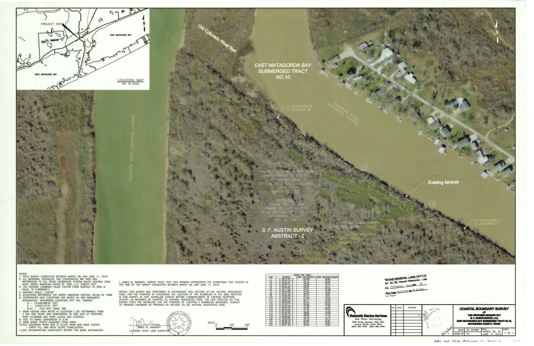
Matagorda County NRC Article 33.136 Sketch 6
Coastal Boundary Survey at the proposed Bragg's Cut S.F. Austin survey, A-2, East Matagorda Bay submerged tract No. 10
-
Map/Doc
94646
-
Collection
General Map Collection
-
Object Dates
2010/8/23 (Creation Date)
2018/6/20 (File Date)
-
People and Organizations
James M. Naismith (Surveyor/Engineer)
-
Counties
Matagorda
-
Subjects
Surveying CBS
-
Height x Width
22.0 x 34.0 inches
55.9 x 86.4 cm
-
Medium
multi-page, multi-format
-
Comments
Project: Bragg's Cut - Matagorda County Project No.: SL20100061 (GLO)
Part of: General Map Collection
Galveston County Working Sketch 14

Print $20.00
- Digital $50.00
Galveston County Working Sketch 14
1978
Size 33.6 x 40.4 inches
Map/Doc 69351
Trinity River, Hughes Crossing Sheet/Chambers Creek

Print $6.00
- Digital $50.00
Trinity River, Hughes Crossing Sheet/Chambers Creek
1931
Size 32.5 x 30.2 inches
Map/Doc 65239
Hutchinson County Working Sketch 16

Print $20.00
- Digital $50.00
Hutchinson County Working Sketch 16
1953
Size 23.0 x 36.3 inches
Map/Doc 66374

Austin County Sketch File 3

Print $40.00
- Digital $50.00
Austin County Sketch File 3
Size 17.1 x 13.6 inches
Map/Doc 10870
Flight Mission No. CRC-5R, Frame 41, Chambers County

Print $20.00
- Digital $50.00
Flight Mission No. CRC-5R, Frame 41, Chambers County
1956
Size 18.7 x 22.3 inches
Map/Doc 84960
Milam County Working Sketch 13

Print $20.00
- Digital $50.00
Milam County Working Sketch 13
2004
Size 34.1 x 46.0 inches
Map/Doc 83578

Terrell County

Print $40.00
- Digital $50.00
Terrell County
1931
Size 48.5 x 40.5 inches
Map/Doc 73300
Flight Mission No. BRA-6M, Frame 152, Jefferson County

Print $20.00
- Digital $50.00
Flight Mission No. BRA-6M, Frame 152, Jefferson County
1953
Size 18.6 x 22.3 inches
Map/Doc 85453
Plot of a survey made to connect the surveys in Jackson County with those heretofore made in connection with Colorado County

Print $2.00
- Digital $50.00
Plot of a survey made to connect the surveys in Jackson County with those heretofore made in connection with Colorado County
1847
Size 12.8 x 7.7 inches
Map/Doc 188
Jeff Davis County Sketch File 33

Print $40.00
- Digital $50.00
Jeff Davis County Sketch File 33
1944
Size 48.2 x 26.0 inches
Map/Doc 10507
You may also like
Val Verde County Sketch File A2

Print $10.00
- Digital $50.00
Val Verde County Sketch File A2
1916
Size 14.5 x 9.1 inches
Map/Doc 39041
Maverick County Working Sketch 13

Print $20.00
- Digital $50.00
Maverick County Working Sketch 13
1969
Size 27.3 x 35.8 inches
Map/Doc 70905
Cottle County

Print $20.00
- Digital $50.00
Cottle County
1908
Size 45.0 x 41.0 inches
Map/Doc 66789
Flight Mission No. CRK-5P, Frame 155, Refugio County

Print $20.00
- Digital $50.00
Flight Mission No. CRK-5P, Frame 155, Refugio County
1956
Size 18.7 x 22.6 inches
Map/Doc 86936
Red River County Sketch File 8b

Print $6.00
- Digital $50.00
Red River County Sketch File 8b
1860
Size 8.2 x 3.7 inches
Map/Doc 35114

Freestone County Working Sketch 9

Print $20.00
- Digital $50.00
Freestone County Working Sketch 9
1975
Size 26.3 x 38.4 inches
Map/Doc 69251
Terrell County Sketch File 22A

Print $20.00
- Digital $50.00
Terrell County Sketch File 22A
Size 21.7 x 11.4 inches
Map/Doc 12422
Schleicher County Sketch File 34

Print $20.00
- Digital $50.00
Schleicher County Sketch File 34
1949
Size 18.7 x 31.7 inches
Map/Doc 12307
Flight Mission No. DIX-5P, Frame 111, Aransas County

Print $20.00
- Digital $50.00
Flight Mission No. DIX-5P, Frame 111, Aransas County
1956
Size 17.6 x 18.0 inches
Map/Doc 83790
Erath County Sketch File 35

Print $8.00
- Digital $50.00
Erath County Sketch File 35
1992
Size 14.5 x 8.8 inches
Map/Doc 22326
Loving County Rolled Sketch 1

Print $40.00
- Digital $50.00
Loving County Rolled Sketch 1
Size 42.5 x 79.5 inches
Map/Doc 9460