Harris County NRC Article 33.136 Sketch 13
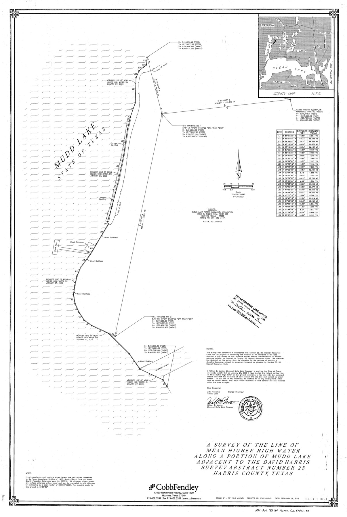
A survey of the line of mean higher high water along a portin of Mudd Lake adjacent to the David Harris survey abstract number 25
- 
                          Map/Doc
94641
 - 
                            Collection
General Map Collection
 - 
                            Object Dates
2009/2/16 (Creation Date)
2018/6/20 (File Date)
 - 
                            People and Organizations
William E. Merten (Surveyor/Engineer)
 - 
                            Counties
Harris
 - 
                            Subjects
Surveying CBS
 - 
                            Height x Width
36.0 x 24.3 inches
91.4 x 61.7 cm
 - 
                            Medium
multi-page, multi-format
 - 
                            Scale
1" = 30'
 - 
                            Comments
Project: Clear Lake Forest Community Park Marsh Creation/Mudd Lake Project No.: CE970616 (GLO)
 
Part of: General Map Collection
            Brazoria County Rolled Sketch 50A


                                            Print $20.00                    
                                             -                         Digital $50.00                                    
                Brazoria County Rolled Sketch 50A
1932
Size 17.8 x 26.1 inches
                                Map/Doc 5188
            
            Map of Cooke County originally Fannin Land District


                                            Print $20.00                    
                                             -                         Digital $50.00                                    
                Map of Cooke County originally Fannin Land District
1858
Size 25.4 x 18.9 inches
                                Map/Doc 950
            
            Williamson County Working Sketch Graphic Index


                                            Print $40.00                    
                                             -                         Digital $50.00                                    
                Williamson County Working Sketch Graphic Index
1946
Size 38.4 x 55.7 inches
                                Map/Doc 76742
            
            Current Miscellaneous File 23


                                            Print $4.00                    
                                             -                         Digital $50.00                                    
                Current Miscellaneous File 23
1953
Size 14.1 x 5.5 inches
                                Map/Doc 73881
            
            Denton County Boundary File 1a


                                            Print $24.00                    
                                             -                         Digital $50.00                                    
                Denton County Boundary File 1a
Size 12.4 x 8.1 inches
                                Map/Doc 52401
            
            Aransas Pass to Baffin Bay


                                            Print $20.00                    
                                             -                         Digital $50.00                                    
                Aransas Pass to Baffin Bay
1966
Size 42.3 x 35.0 inches
                                Map/Doc 73415
            
            Terrell County Sketch File 4


                                            Print $12.00                    
                                             -                         Digital $50.00                                    
                Terrell County Sketch File 4
1881
Map/Doc 12417
            
            United States Atlantic and Gulf Coasts Including Puerto Rico and the Virgin Islands


                                            Print $40.00                    
                                             -                         Digital $50.00                                    
                United States Atlantic and Gulf Coasts Including Puerto Rico and the Virgin Islands
1973
Size 21.9 x 60.6 inches
                                Map/Doc 76125
            
            Flight Mission No. BRA-7M, Frame 197, Jefferson County


                                            Print $20.00                    
                                             -                         Digital $50.00                                    
                Flight Mission No. BRA-7M, Frame 197, Jefferson County
1953
Size 18.6 x 22.4 inches
                                Map/Doc 85565
            
            Jasper County


                                            Print $40.00                    
                                             -                         Digital $50.00                                    
                Jasper County
1946
Size 48.6 x 42.9 inches
                                Map/Doc 73192
            
            Harris County Sketch File 92


                                            Print $20.00                    
                                             -                         Digital $50.00                                    
                Harris County Sketch File 92
1932
Size 37.9 x 35.0 inches
                                Map/Doc 10483
            
            Right of Way and Track Map, The Missouri, Kansas and Texas Ry. of Texas operated by the Missouri, Kansas and Texas Ry. of Texas, Henrietta Division


                                            Print $40.00                    
                                             -                         Digital $50.00                                    
                Right of Way and Track Map, The Missouri, Kansas and Texas Ry. of Texas operated by the Missouri, Kansas and Texas Ry. of Texas, Henrietta Division
1918
Size 25.4 x 57.2 inches
                                Map/Doc 64073
            You may also like
            Palo Pinto County Boundary File 4a


                                            Print $34.00                    
                                             -                         Digital $50.00                                    
                Palo Pinto County Boundary File 4a
Size 13.3 x 8.9 inches
                                Map/Doc 57817
            
            Palo Pinto County Working Sketch 17


                                            Print $40.00                    
                                             -                         Digital $50.00                                    
                Palo Pinto County Working Sketch 17
1974
Size 30.0 x 53.8 inches
                                Map/Doc 71400
            
            Atascosa County Sketch File 36


                                            Print $20.00                    
                                             -                         Digital $50.00                                    
                Atascosa County Sketch File 36
1947
Size 16.0 x 22.3 inches
                                Map/Doc 10867
            
            Portion of Culberson County, Texas


                                            Print $20.00                    
                                             -                         Digital $50.00                                    
                Portion of Culberson County, Texas
1948
Size 31.1 x 33.2 inches
                                Map/Doc 92609
            
            Bee County Working Sketch 10


                                            Print $20.00                    
                                             -                         Digital $50.00                                    
                Bee County Working Sketch 10
1941
Size 41.2 x 20.4 inches
                                Map/Doc 67260
            
            Flight Mission No. DAG-18K, Frame 184, Matagorda County


                                            Print $20.00                    
                                             -                         Digital $50.00                                    
                Flight Mission No. DAG-18K, Frame 184, Matagorda County
1952
Size 18.6 x 22.4 inches
                                Map/Doc 86376
            
            Somervell County Working Sketch 5


                                            Print $20.00                    
                                             -                         Digital $50.00                                    
                Somervell County Working Sketch 5
1975
Size 33.3 x 39.4 inches
                                Map/Doc 63909
            
            Township No. 5 South Range No. 13 West of the Indian Meridian


                                            Print $4.00                    
                                             -                         Digital $50.00                                    
                Township No. 5 South Range No. 13 West of the Indian Meridian
1875
Size 17.9 x 23.5 inches
                                Map/Doc 75153
            
            Flight Mission No. DCL-7C, Frame 111, Kenedy County


                                            Print $20.00                    
                                             -                         Digital $50.00                                    
                Flight Mission No. DCL-7C, Frame 111, Kenedy County
1943
Size 18.5 x 22.3 inches
                                Map/Doc 86076
            
            Sanderson and Terrell County, Texas


            Sanderson and Terrell County, Texas
1920
Size 6.3 x 3.5 inches
                                Map/Doc 97073
            
            Cooke County Sketch File 28


                                            Print $4.00                    
                                             -                         Digital $50.00                                    
                Cooke County Sketch File 28
1872
Size 12.8 x 8.5 inches
                                Map/Doc 19281
            
            The Rand McNally New Commercial Atlas Map of Texas


                                            Print $20.00                    
                                             -                         Digital $50.00                                    
                The Rand McNally New Commercial Atlas Map of Texas
1920
Size 29.0 x 40.1 inches
                                Map/Doc 95863