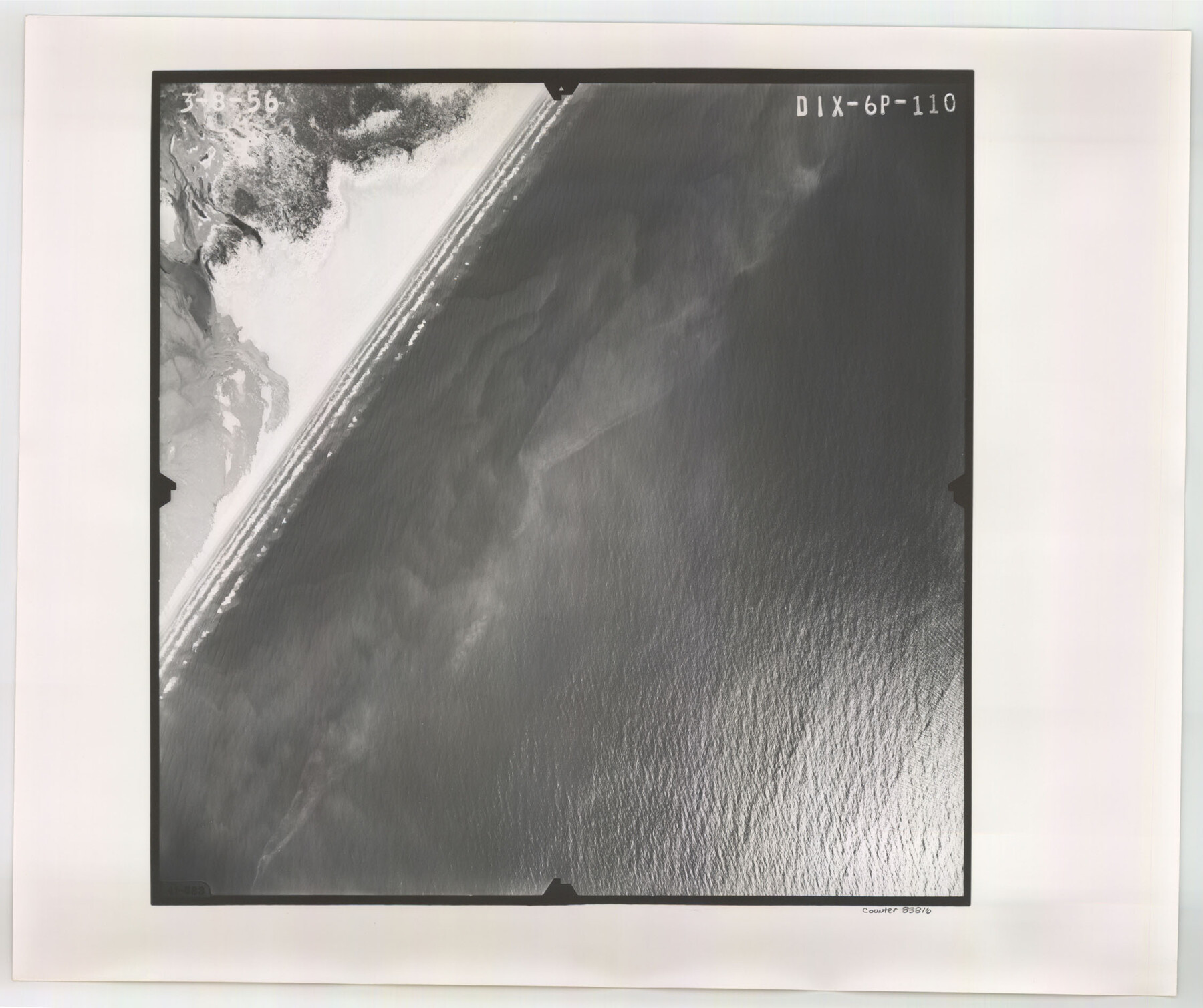
Flight Mission No. DIX-6P, Frame 110, Aransas County
DIX-6P-110
-
Map/Doc
83816
-
Collection
General Map Collection
-
Object Dates
1956/3/8 (Creation Date)
-
People and Organizations
U. S. Department of Agriculture (Publisher)
-
Counties
Aransas
-
Subjects
Aerial Photograph
-
Height x Width
19.7 x 23.4 inches
50.0 x 59.4 cm
-
Comments
Flown by V. L. Beavers and Associates of San Antonio, Texas.
Part of: General Map Collection
Victoria County Boundary File 91

Print $12.00
- Digital $50.00
Victoria County Boundary File 91
Size 8.9 x 6.5 inches
Map/Doc 59620
Map of section no. 6 of a survey of Padre Island made for the Office of the Attorney General of the State of Texas

Print $40.00
- Digital $50.00
Map of section no. 6 of a survey of Padre Island made for the Office of the Attorney General of the State of Texas
1941
Size 57.9 x 40.8 inches
Map/Doc 2262
Hale County Sketch File C

Print $20.00
- Digital $50.00
Hale County Sketch File C
1901
Size 20.1 x 24.1 inches
Map/Doc 11600
Grayson County Rolled Sketch 1

Print $20.00
- Digital $50.00
Grayson County Rolled Sketch 1
1944
Size 43.4 x 29.0 inches
Map/Doc 6029
El Paso County Working Sketch 34

Print $40.00
- Digital $50.00
El Paso County Working Sketch 34
1974
Size 53.4 x 34.7 inches
Map/Doc 69056
Cass County Rolled Sketch 5A

Print $20.00
- Digital $50.00
Cass County Rolled Sketch 5A
Size 15.4 x 18.0 inches
Map/Doc 5411
Palo Pinto County Working Sketch 15

Print $20.00
- Digital $50.00
Palo Pinto County Working Sketch 15
1971
Size 26.4 x 30.8 inches
Map/Doc 71398
Jefferson County Rolled Sketch 37

Print $20.00
- Digital $50.00
Jefferson County Rolled Sketch 37
1957
Size 36.4 x 30.1 inches
Map/Doc 6396
Pecos County Rolled Sketch 59

Print $20.00
- Digital $50.00
Pecos County Rolled Sketch 59
1922
Size 16.6 x 17.0 inches
Map/Doc 7231
Brewster County Working Sketch 62

Print $20.00
- Digital $50.00
Brewster County Working Sketch 62
1956
Size 22.7 x 20.2 inches
Map/Doc 67663
Henderson County Working Sketch 24

Print $20.00
- Digital $50.00
Henderson County Working Sketch 24
1952
Size 29.3 x 22.9 inches
Map/Doc 66157
Colorado River, Buecher State Park

Print $4.00
- Digital $50.00
Colorado River, Buecher State Park
1934
Size 20.8 x 11.6 inches
Map/Doc 65324
You may also like
Kleberg County Rolled Sketch 10-7

Print $20.00
- Digital $50.00
Kleberg County Rolled Sketch 10-7
1953
Size 37.3 x 34.5 inches
Map/Doc 9401
The Judicial District/County of Neches. Created, January 29, 1842

Print $20.00
The Judicial District/County of Neches. Created, January 29, 1842
2020
Size 15.5 x 21.7 inches
Map/Doc 96338
Wichita County

Print $20.00
- Digital $50.00
Wichita County
1971
Size 38.1 x 39.8 inches
Map/Doc 73323
[Leagues 212- 217, 241- 244, and Vicinity]
![91430, [Leagues 212- 217, 241- 244, and Vicinity], Twichell Survey Records](https://historictexasmaps.com/wmedia_w700/maps/91430-1.tif.jpg)
Print $20.00
- Digital $50.00
[Leagues 212- 217, 241- 244, and Vicinity]
1902
Size 20.6 x 6.4 inches
Map/Doc 91430
Collingsworth County, Texas

Print $20.00
- Digital $50.00
Collingsworth County, Texas
Size 18.3 x 16.6 inches
Map/Doc 465
I. & G. N. - International and Great Northern R.R. - International Route - Galveston, Ft. Worth, Waco, Houston, Austin, Laredo, San Antonio

Print $20.00
- Digital $50.00
I. & G. N. - International and Great Northern R.R. - International Route - Galveston, Ft. Worth, Waco, Houston, Austin, Laredo, San Antonio
1910
Size 24.0 x 16.2 inches
Map/Doc 95779
Van Zandt County Working Sketch 12

Print $20.00
- Digital $50.00
Van Zandt County Working Sketch 12
1982
Size 21.5 x 20.7 inches
Map/Doc 72262
[Floyd County School Land Lgs. 180-183, Fisher County School Land Lgs. 105-108, and part of Blk. V]
![90193, [Floyd County Schoo Land Lgs. 180-183, Fisher County School Land Lgs. 105-108, and part of Blk. V], Twichell Survey Records](https://historictexasmaps.com/wmedia_w700/maps/90193-1.tif.jpg)
Print $2.00
- Digital $50.00
[Floyd County School Land Lgs. 180-183, Fisher County School Land Lgs. 105-108, and part of Blk. V]
Size 8.7 x 10.2 inches
Map/Doc 90193
Levelland, Hockley County, Texas

Print $20.00
- Digital $50.00
Levelland, Hockley County, Texas
1950
Size 13.1 x 14.9 inches
Map/Doc 92241
Armstrong County Working Sketch 8

Print $20.00
- Digital $50.00
Armstrong County Working Sketch 8
1902
Size 25.4 x 40.2 inches
Map/Doc 67239

Flight Mission No. BQR-16K, Frame 31, Brazoria County

Print $20.00
- Digital $50.00
Flight Mission No. BQR-16K, Frame 31, Brazoria County
1952
Size 18.5 x 22.1 inches
Map/Doc 84098