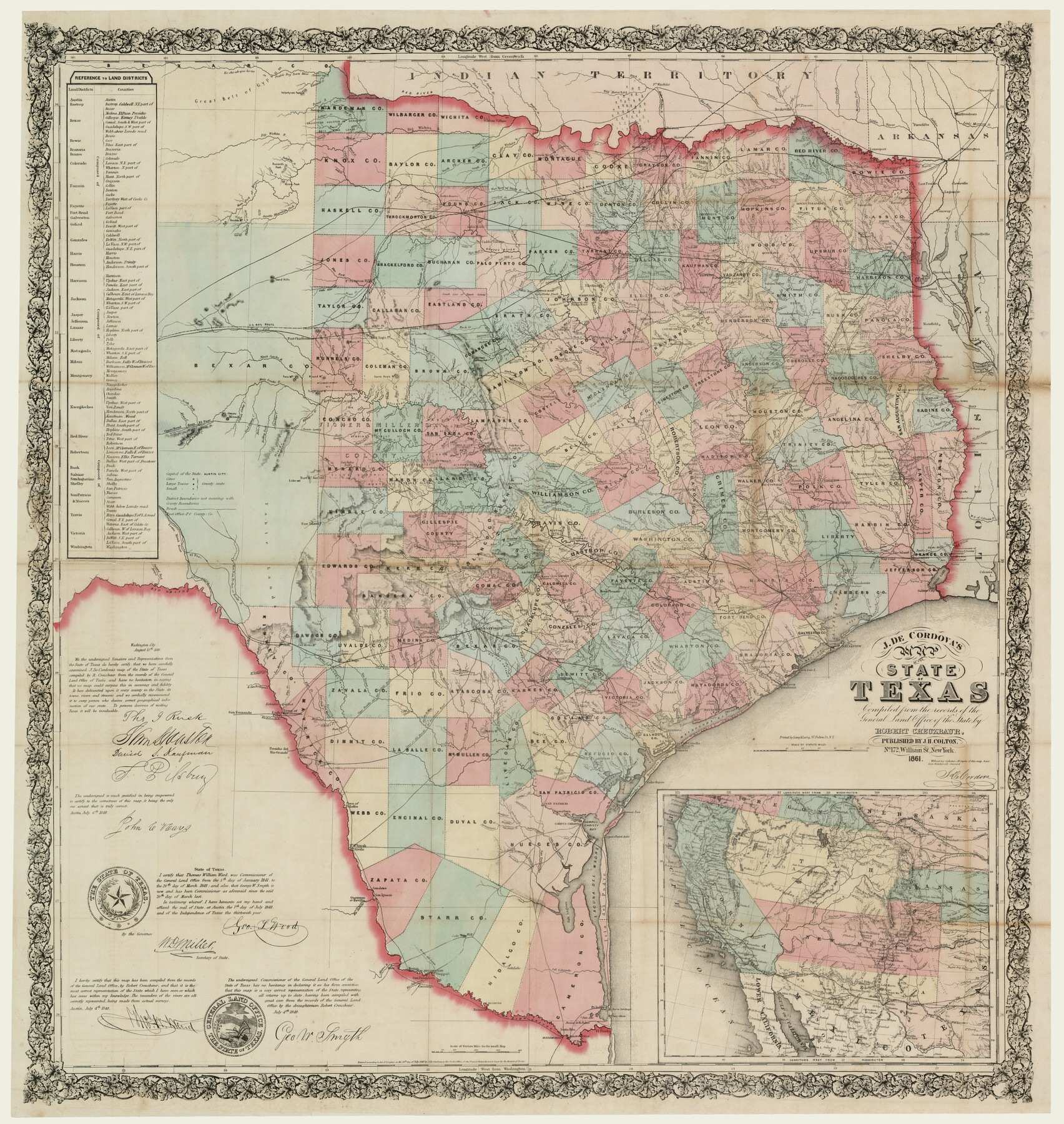
J. De Cordova's Map of the State of Texas Compiled from the records of the General Land Office of the State
K-4-12
-
Map/Doc
93931
-
Collection
Rees-Jones Digital Map Collection
-
Object Dates
1861 (Creation Date)
-
People and Organizations
Jacob De Cordova (Publisher)
J. M. Atwood (Printer)
Thomas William Ward (GLO Commissioner)
Robert Creuzbaur (Compiler)
Robert Creuzbaur (Draftsman)
George W. Smyth (GLO Commissioner)
Jacob De Cordova (Author)
-
Subjects
State of Texas
-
Height x Width
36.9 x 34.9 inches
93.7 x 88.7 cm
-
Comments
Inset shows Texas in present configuration after Compromise of 1850.
Conservation funded in 2001 with donations from Clear Lake Area Chamber of Commerce and Clear Lake and NASA Area Convention and Visitors Bureau.
Part of: Rees-Jones Digital Map Collection
Chart of the Antarctic Continent shewing the icy barrier attached to it discovered by the U.S. Ex. Ex.

Print $20.00
- Digital $50.00
Chart of the Antarctic Continent shewing the icy barrier attached to it discovered by the U.S. Ex. Ex.
1840
Size 26.5 x 37.2 inches
Map/Doc 94059
Guide map of the Great Texas Cattle Trail from Red River crossing to the Old Reliable Kansas Pacific Railway

Print $20.00
- Digital $50.00
Guide map of the Great Texas Cattle Trail from Red River crossing to the Old Reliable Kansas Pacific Railway
1873
Size 23.4 x 17.6 inches
Map/Doc 93938
A new map of Texas, Oregon and California with the regions adjoining, compiled from the most recent authorities

Print $20.00
- Digital $50.00
A new map of Texas, Oregon and California with the regions adjoining, compiled from the most recent authorities
1846
Size 23.7 x 21.8 inches
Map/Doc 93940
J. De Cordova's Map of the State of Texas Compiled from the records of the General Land Office of the State

Print $20.00
- Digital $50.00
J. De Cordova's Map of the State of Texas Compiled from the records of the General Land Office of the State
Size 38.5 x 36.4 inches
Map/Doc 93984
Rand, McNally & Co's New Mexico

Print $20.00
- Digital $50.00
Rand, McNally & Co's New Mexico
1880
Size 21.4 x 14.7 inches
Map/Doc 94050
Minnesota Route the shortest and best to the Idaho Gold Mines

Print $20.00
- Digital $50.00
Minnesota Route the shortest and best to the Idaho Gold Mines
Size 21.0 x 46.3 inches
Map/Doc 93989
A New Map of Nebraska, Kansas, New Mexico and Indian Territories

Print $20.00
- Digital $50.00
A New Map of Nebraska, Kansas, New Mexico and Indian Territories
Size 18.6 x 15.2 inches
Map/Doc 93985
Chart of the Antarctic Continent shewing the icy barrier attached to it discovered by the U.S. Ex. Ex.

Print $20.00
- Digital $50.00
Chart of the Antarctic Continent shewing the icy barrier attached to it discovered by the U.S. Ex. Ex.
1840
Size 26.5 x 37.2 inches
Map/Doc 94058
A New Map of Texas with the Contiguous American & Mexican States

Print $20.00
- Digital $50.00
A New Map of Texas with the Contiguous American & Mexican States
1839
Size 13.5 x 16.1 inches
Map/Doc 93941
Kansas and Nebraska

Print $20.00
- Digital $50.00
Kansas and Nebraska
Size 30.8 x 19.4 inches
Map/Doc 93994
A map of the Anthracite Coal Fields of Pennsylvania embracing all of Schuylkill County and parts of Carbon, Luzerne, Columbia, Northumberland, Dauphin, and Lebanon Counties

Print $20.00
- Digital $50.00
A map of the Anthracite Coal Fields of Pennsylvania embracing all of Schuylkill County and parts of Carbon, Luzerne, Columbia, Northumberland, Dauphin, and Lebanon Counties
1863
Size 27.1 x 39.3 inches
Map/Doc 94054
A new map of the states of Texas & California, the territories of Oregon, New Mexico, Utah, and the regions adjacent: compiled from the most recent authorities

Print $20.00
- Digital $50.00
A new map of the states of Texas & California, the territories of Oregon, New Mexico, Utah, and the regions adjacent: compiled from the most recent authorities
1851
Size 22.4 x 20.4 inches
Map/Doc 94051
You may also like
Harrison County Rolled Sketch 7

Print $20.00
- Digital $50.00
Harrison County Rolled Sketch 7
1953
Size 36.0 x 37.1 inches
Map/Doc 9144
Flight Mission No. DCL-5C, Frame 77, Kenedy County

Print $20.00
- Digital $50.00
Flight Mission No. DCL-5C, Frame 77, Kenedy County
1943
Size 18.5 x 22.4 inches
Map/Doc 85860
Wood County Boundary File 5

Print $20.00
- Digital $50.00
Wood County Boundary File 5
Size 10.8 x 8.1 inches
Map/Doc 60170
Bosque County Sketch File 15

Print $14.00
- Digital $50.00
Bosque County Sketch File 15
1863
Size 12.3 x 7.7 inches
Map/Doc 14774
Panola County Sketch File 18

Print $20.00
- Digital $50.00
Panola County Sketch File 18
1909
Size 24.2 x 18.7 inches
Map/Doc 12138
Duval County Sketch File 4c1

Print $4.00
- Digital $50.00
Duval County Sketch File 4c1
1874
Size 10.4 x 7.9 inches
Map/Doc 21286
Atascosa County Sketch File 30

Print $18.00
- Digital $50.00
Atascosa County Sketch File 30
1900
Size 11.2 x 8.8 inches
Map/Doc 13816
Map of Galveston, Harrisburg & San Antonio Railway in Pecos County

Print $40.00
- Digital $50.00
Map of Galveston, Harrisburg & San Antonio Railway in Pecos County
1888
Size 26.0 x 80.9 inches
Map/Doc 64399
Trinity River, Boyd Crossing Sheet/Chambers Creek

Print $20.00
- Digital $50.00
Trinity River, Boyd Crossing Sheet/Chambers Creek
1931
Size 17.5 x 43.1 inches
Map/Doc 65238
Nueces County Sketch File 52

Print $10.00
- Digital $50.00
Nueces County Sketch File 52
1947
Size 14.1 x 8.6 inches
Map/Doc 32858
Bandera County Working Sketch 51

Print $40.00
- Digital $50.00
Bandera County Working Sketch 51
1985
Size 49.8 x 44.3 inches
Map/Doc 67647
Montgomery County Working Sketch 6

Print $20.00
- Digital $50.00
Montgomery County Working Sketch 6
1932
Size 24.8 x 32.2 inches
Map/Doc 71112