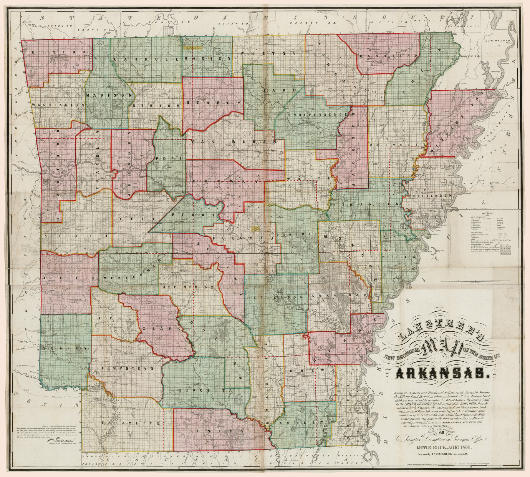
Langtree's New Sectional Map of the State of Arkansas
-
Map/Doc
93987
-
Collection
Rees-Jones Digital Map Collection
-
People and Organizations
C. Langtree (Publisher)
Edwin O. Reed (Printer)
-
Subjects
Old Southwest
-
Height x Width
34.6 x 38.4 inches
87.9 x 97.5 cm
-
Medium
paper
-
Comments
Courtesy of the Rees-Jones Collection, Dallas, TX.
Part of: Rees-Jones Digital Map Collection
Map of the Oregon Territory by the U.S. Ex. Ex.

Print $20.00
- Digital $50.00
Map of the Oregon Territory by the U.S. Ex. Ex.
1841
Size 26.2 x 37.3 inches
Map/Doc 94060
Minnesota Route the shortest and best to the Idaho Gold Mines

Print $20.00
- Digital $50.00
Minnesota Route the shortest and best to the Idaho Gold Mines
Size 21.0 x 46.3 inches
Map/Doc 93989
Part of the boundary between the United States and Texas; from Sabine River northward to the 36th mile mound

Print $2.00
- Digital $50.00
Part of the boundary between the United States and Texas; from Sabine River northward to the 36th mile mound
1842
Size 12.5 x 7.6 inches
Map/Doc 93769
Colton's new map of the State of Texas, the Indian Territory and adjoining portions of New Mexico, Louisiana and Arkansas

Print $20.00
- Digital $50.00
Colton's new map of the State of Texas, the Indian Territory and adjoining portions of New Mexico, Louisiana and Arkansas
1874
Size 34.7 x 38.7 inches
Map/Doc 93762
Nouvelle carte du Mexique, du Texas et d'une partie des États Limitrophes

Print $20.00
- Digital $50.00
Nouvelle carte du Mexique, du Texas et d'une partie des États Limitrophes
1834
Size 39.5 x 27.2 inches
Map/Doc 93764
Langtree's New Sectional Map of the State of Arkansas

Print $20.00
- Digital $50.00
Langtree's New Sectional Map of the State of Arkansas
Size 34.6 x 38.4 inches
Map/Doc 93987
Chart of the World shewing the tracks of the U.S. Exploring Expedition in 1833, 39, 40, 41 & 42

Print $20.00
- Digital $50.00
Chart of the World shewing the tracks of the U.S. Exploring Expedition in 1833, 39, 40, 41 & 42
1842
Size 26.3 x 37.4 inches
Map/Doc 94057
Guide map of the Great Texas Cattle Trail from Red River crossing to the Old Reliable Kansas Pacific Railway

Print $20.00
- Digital $50.00
Guide map of the Great Texas Cattle Trail from Red River crossing to the Old Reliable Kansas Pacific Railway
1873
Size 23.4 x 17.6 inches
Map/Doc 93938
Geological map of Texas showing approximate locations and drilling wells. Also names of companies drilling

Print $20.00
- Digital $50.00
Geological map of Texas showing approximate locations and drilling wells. Also names of companies drilling
1920
Size 26.9 x 26.6 inches
Map/Doc 93937
A New Map of the United States upon which are delineated its vast works of internal communication, routes across the continent &c. showing also Canada and the Island of Cuba

Print $20.00
- Digital $50.00
A New Map of the United States upon which are delineated its vast works of internal communication, routes across the continent &c. showing also Canada and the Island of Cuba
Size 25.8 x 30.6 inches
Map/Doc 93996
Map of part of the island of Hawaii Sandwich Islands shewing the craters and eruption of May and June 1840 by the U.S. Ex. Ex.

Print $20.00
- Digital $50.00
Map of part of the island of Hawaii Sandwich Islands shewing the craters and eruption of May and June 1840 by the U.S. Ex. Ex.
1841
Size 18.4 x 25.9 inches
Map/Doc 94061
A new map of Texas, Oregon and California with the regions adjoining, compiled from the most recent authorities

Print $20.00
- Digital $50.00
A new map of Texas, Oregon and California with the regions adjoining, compiled from the most recent authorities
1846
Size 23.7 x 21.8 inches
Map/Doc 93940
You may also like
Ward County Rolled Sketch 9

Print $40.00
- Digital $50.00
Ward County Rolled Sketch 9
1936
Size 51.5 x 41.9 inches
Map/Doc 10105
Southeast Corner of Gray County

Print $20.00
- Digital $50.00
Southeast Corner of Gray County
1882
Size 18.8 x 22.6 inches
Map/Doc 90757
Oil and Gas Fields of the State of Texas

Print $40.00
- Digital $50.00
Oil and Gas Fields of the State of Texas
1931
Size 38.4 x 59.2 inches
Map/Doc 89885
Flight Mission No. BQY-4M, Frame 69, Harris County

Print $20.00
- Digital $50.00
Flight Mission No. BQY-4M, Frame 69, Harris County
1953
Size 18.6 x 22.4 inches
Map/Doc 85278
McCulloch County Working Sketch 10

Print $20.00
- Digital $50.00
McCulloch County Working Sketch 10
1979
Size 19.1 x 21.2 inches
Map/Doc 70685
Flight Mission No. BRE-2P, Frame 100, Nueces County

Print $20.00
- Digital $50.00
Flight Mission No. BRE-2P, Frame 100, Nueces County
1956
Size 18.5 x 22.3 inches
Map/Doc 86785
Garza County Sketch File 7

Print $4.00
- Digital $50.00
Garza County Sketch File 7
1900
Size 13.3 x 8.5 inches
Map/Doc 24060
Morley's Map of New Mexico compiled from the latest government surveys and other reliable sources

Print $20.00
- Digital $50.00
Morley's Map of New Mexico compiled from the latest government surveys and other reliable sources
1873
Size 26.2 x 28.0 inches
Map/Doc 94052
Cuadro Historico-Geroglifico de la Peregrinacion de las Tribus Aztecas que Poblaron el Valle de Mexico (Num. 2)

Print $20.00
- Digital $50.00
Cuadro Historico-Geroglifico de la Peregrinacion de las Tribus Aztecas que Poblaron el Valle de Mexico (Num. 2)
Size 22.9 x 31.3 inches
Map/Doc 97012
Hood County Working Sketch 10

Print $20.00
- Digital $50.00
Hood County Working Sketch 10
1974
Size 26.7 x 35.6 inches
Map/Doc 66204
Eastland County Rolled Sketch 19

Print $20.00
- Digital $50.00
Eastland County Rolled Sketch 19
1980
Size 28.9 x 30.9 inches
Map/Doc 8825
Duval County Boundary File 3c

Print $12.00
- Digital $50.00
Duval County Boundary File 3c
Size 11.7 x 8.4 inches
Map/Doc 52732