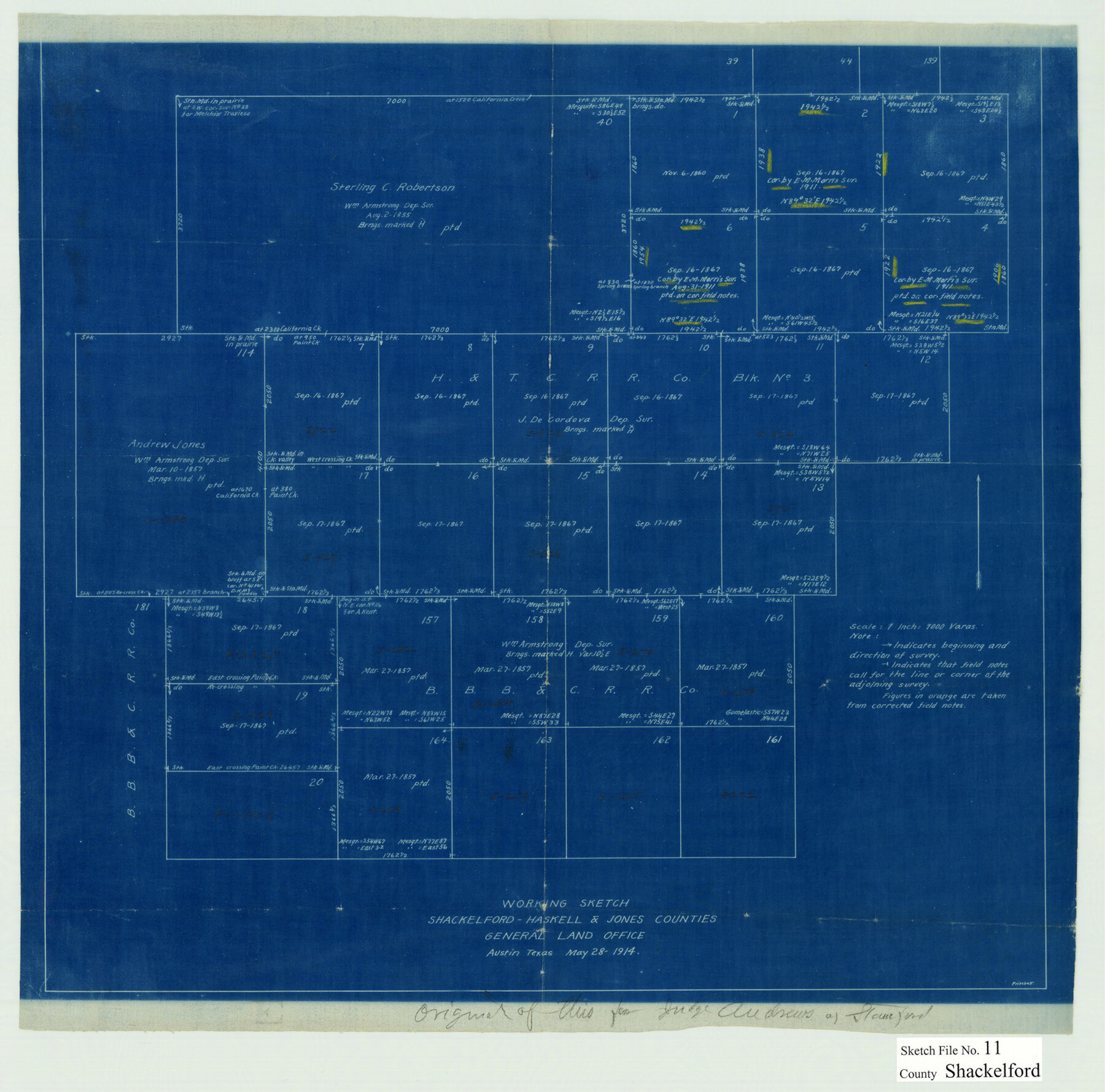
Shackelford County Sketch File 11
[Working sketch of surveys at the intersection of Shackelford, Haskell, and Jones Counties]
-
Map/Doc
12317
-
Collection
General Map Collection
-
Object Dates
5/28/1914 (Creation Date)
-
Counties
Shackelford Haskell Jones
-
Subjects
Surveying Sketch File
-
Height x Width
16.8 x 17.0 inches
42.7 x 43.2 cm
-
Medium
blueprint/diazo
-
Scale
1" = 1000 varas
Part of: General Map Collection
Coleman County Sketch File 20

Print $4.00
- Digital $50.00
Coleman County Sketch File 20
1871
Size 12.9 x 8.0 inches
Map/Doc 18694
Sabine County Sketch File 5

Print $8.00
Sabine County Sketch File 5
1876
Size 12.9 x 8.5 inches
Map/Doc 35608
[Texas & Pacific Railway through Callahan County]
![64237, [Texas & Pacific Railway through Callahan County], General Map Collection](https://historictexasmaps.com/wmedia_w700/maps/64237.tif.jpg)
Print $20.00
- Digital $50.00
[Texas & Pacific Railway through Callahan County]
1918
Size 21.8 x 9.2 inches
Map/Doc 64237
Ashburn's San Antonio City Map

Ashburn's San Antonio City Map
1951
Size 24.5 x 19.5 inches
Map/Doc 97144
Texas-Oklahoma Clarksville Quadrangle

Print $20.00
- Digital $50.00
Texas-Oklahoma Clarksville Quadrangle
Size 22.2 x 18.3 inches
Map/Doc 75109
Mitchell County Boundary File 66

Print $13.00
- Digital $50.00
Mitchell County Boundary File 66
Size 7.9 x 3.7 inches
Map/Doc 57372
Nueces County NRC Article 33.136 Sketch 6

Print $44.00
- Digital $50.00
Nueces County NRC Article 33.136 Sketch 6
2002
Size 23.4 x 35.2 inches
Map/Doc 78658
Cass County Rolled Sketch 5B

Print $20.00
- Digital $50.00
Cass County Rolled Sketch 5B
1949
Size 23.5 x 16.4 inches
Map/Doc 5412
Flight Mission No. DQO-8K, Frame 44, Galveston County

Print $20.00
- Digital $50.00
Flight Mission No. DQO-8K, Frame 44, Galveston County
1952
Size 18.5 x 22.3 inches
Map/Doc 85151
Haskell County Rolled Sketch 6

Print $20.00
- Digital $50.00
Haskell County Rolled Sketch 6
1940
Size 22.3 x 19.6 inches
Map/Doc 6166
Flight Mission No. CRC-4R, Frame 97, Chambers County

Print $20.00
- Digital $50.00
Flight Mission No. CRC-4R, Frame 97, Chambers County
1956
Size 18.6 x 22.2 inches
Map/Doc 84894

You may also like
Brewster County Rolled Sketch 102

Print $20.00
- Digital $50.00
Brewster County Rolled Sketch 102
Size 37.0 x 43.4 inches
Map/Doc 8513
Working Sketch Compiled from Original Field Notes Irion County, Texas

Print $20.00
- Digital $50.00
Working Sketch Compiled from Original Field Notes Irion County, Texas
Size 19.4 x 19.5 inches
Map/Doc 92187
Map of Brown County

Print $20.00
- Digital $50.00
Map of Brown County
Size 25.4 x 23.5 inches
Map/Doc 3340
[William Steele Survey near Copano Bay]
![60285, [William Steele Survey near Copano Bay], General Map Collection](https://historictexasmaps.com/wmedia_w700/maps/60285-1.tif.jpg)
Print $3.00
- Digital $50.00
[William Steele Survey near Copano Bay]
1927
Size 14.9 x 9.8 inches
Map/Doc 60285
Roberts County

Print $20.00
- Digital $50.00
Roberts County
1878
Size 20.1 x 18.0 inches
Map/Doc 3991
Stonewall County Working Sketch 12

Print $20.00
- Digital $50.00
Stonewall County Working Sketch 12
1950
Size 27.9 x 27.9 inches
Map/Doc 62319
Pecos County Rolled Sketch 133

Print $40.00
- Digital $50.00
Pecos County Rolled Sketch 133
1952
Size 50.8 x 12.1 inches
Map/Doc 9729
Angelina County Working Sketch 39

Print $20.00
- Digital $50.00
Angelina County Working Sketch 39
1959
Size 25.6 x 30.0 inches
Map/Doc 67122
Baylor County, Texas

Print $20.00
- Digital $50.00
Baylor County, Texas
1879
Size 22.2 x 17.4 inches
Map/Doc 586
Map of Fannin County

Print $20.00
- Digital $50.00
Map of Fannin County
1845
Size 34.7 x 36.5 inches
Map/Doc 16827
The Republic County of Nacogdoches. January 1, 1838

Print $20.00
The Republic County of Nacogdoches. January 1, 1838
2020
Size 17.5 x 21.7 inches
Map/Doc 96244
Flight Mission No. DIX-7P, Frame 88, Aransas County

Print $20.00
- Digital $50.00
Flight Mission No. DIX-7P, Frame 88, Aransas County
1956
Size 18.7 x 22.3 inches
Map/Doc 83882