Kleberg County Rolled Sketch 10-22
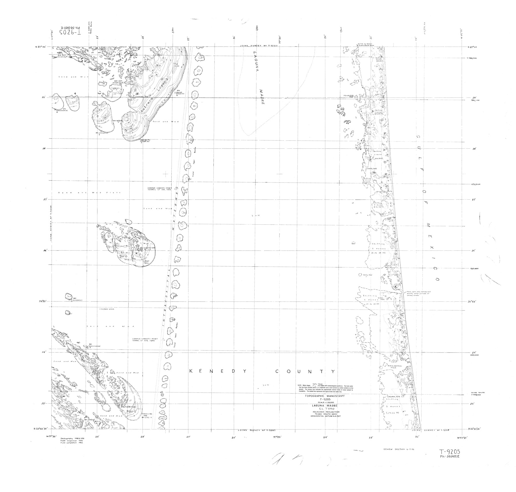
Topographic Manuscript T-9205, Laguna Madre, El Toro
-
Map/Doc
9376
-
Collection
General Map Collection
-
Object Dates
1952 (Creation Date)
-
Counties
Kenedy
-
Subjects
Surveying Rolled Sketch
-
Height x Width
35.1 x 36.8 inches
89.2 x 93.5 cm
Part of: General Map Collection
Palo Pinto County Working Sketch 1

Print $20.00
- Digital $50.00
Palo Pinto County Working Sketch 1
1903
Size 19.0 x 14.6 inches
Map/Doc 71384
[Surveys in the Jasper District]
![69734, [Surveys in the Jasper District], General Map Collection](https://historictexasmaps.com/wmedia_w700/maps/69734.tif.jpg)
Print $2.00
- Digital $50.00
[Surveys in the Jasper District]
1847
Size 9.4 x 6.9 inches
Map/Doc 69734
Gulf Intracoastal Waterway - Aransas Bay to Corpus Christi Bay - Modified Route Main Channel

Print $20.00
- Digital $50.00
Gulf Intracoastal Waterway - Aransas Bay to Corpus Christi Bay - Modified Route Main Channel
1960
Size 30.9 x 42.8 inches
Map/Doc 61900
Presidio County Rolled Sketch 93A

Print $20.00
- Digital $50.00
Presidio County Rolled Sketch 93A
Size 29.6 x 28.2 inches
Map/Doc 7379
Map of The Surveyed Part of Peters Colony Texas

Print $40.00
- Digital $50.00
Map of The Surveyed Part of Peters Colony Texas
1854
Size 53.7 x 32.0 inches
Map/Doc 83007
Part of Laguna Madre from Mosquito Trangulation Station to Sand Triangulation Station

Print $20.00
- Digital $50.00
Part of Laguna Madre from Mosquito Trangulation Station to Sand Triangulation Station
1881
Size 16.4 x 26.9 inches
Map/Doc 73488
Eastland County Working Sketch 4

Print $20.00
- Digital $50.00
Eastland County Working Sketch 4
1918
Size 39.1 x 29.1 inches
Map/Doc 68785
Jasper County

Print $40.00
- Digital $50.00
Jasper County
1946
Size 48.6 x 42.9 inches
Map/Doc 73192
[Sketch for Mineral Application 19560 - 19588 - San Bernard River]
![65660, [Sketch for Mineral Application 19560 - 19588 - San Bernard River], General Map Collection](https://historictexasmaps.com/wmedia_w700/maps/65660.tif.jpg)
Print $40.00
- Digital $50.00
[Sketch for Mineral Application 19560 - 19588 - San Bernard River]
Size 98.0 x 33.0 inches
Map/Doc 65660
Melish's Map Tracing, Surveys on the Red River [See Texas-US Boundary Line File 2]

Digital $50.00
Melish's Map Tracing, Surveys on the Red River [See Texas-US Boundary Line File 2]
Map/Doc 2072
Map of Uvalde County

Print $20.00
- Digital $50.00
Map of Uvalde County
1862
Size 27.4 x 20.7 inches
Map/Doc 4109
El Paso County Working Sketch 59

Print $20.00
- Digital $50.00
El Paso County Working Sketch 59
2000
Size 28.1 x 35.7 inches
Map/Doc 69081
You may also like
Map of east part of West Bay & SW part of Galveston Bay, Galveston County showing subdivision for mineral development

Print $40.00
- Digital $50.00
Map of east part of West Bay & SW part of Galveston Bay, Galveston County showing subdivision for mineral development
1963
Size 42.0 x 59.6 inches
Map/Doc 3069
Parker County Sketch File B

Print $24.00
- Digital $50.00
Parker County Sketch File B
1858
Size 12.5 x 8.2 inches
Map/Doc 33509
Bastrop County Sketch File 13

Print $6.00
- Digital $50.00
Bastrop County Sketch File 13
1845
Size 10.1 x 15.8 inches
Map/Doc 14070
Concho County Sketch File 23

Print $6.00
- Digital $50.00
Concho County Sketch File 23
Size 11.0 x 7.3 inches
Map/Doc 19146
Map of La Salle County

Print $20.00
- Digital $50.00
Map of La Salle County
1877
Size 29.7 x 21.6 inches
Map/Doc 3796
Donley County Boundary File 8

Print $4.00
- Digital $50.00
Donley County Boundary File 8
Size 11.2 x 8.7 inches
Map/Doc 52655
[R. T. Bucy's Survey 3, League 321]
![91348, [R. T. Bucy's Survey 3, League 321], Twichell Survey Records](https://historictexasmaps.com/wmedia_w700/maps/91348.tif.jpg)
Digital $50.00
[R. T. Bucy's Survey 3, League 321]
Map/Doc 91348
Roberts County

Print $20.00
- Digital $50.00
Roberts County
1889
Size 20.8 x 19.8 inches
Map/Doc 3993
J.K Gill & Cos Map of Oregon

Print $20.00
- Digital $50.00
J.K Gill & Cos Map of Oregon
1882
Size 29.0 x 32.3 inches
Map/Doc 94055
Johnson County Sketch File 10a

Print $4.00
- Digital $50.00
Johnson County Sketch File 10a
1877
Size 6.7 x 10.6 inches
Map/Doc 28445
Palo Pinto County Sketch File 4

Print $4.00
- Digital $50.00
Palo Pinto County Sketch File 4
1870
Size 8.2 x 12.9 inches
Map/Doc 33394
