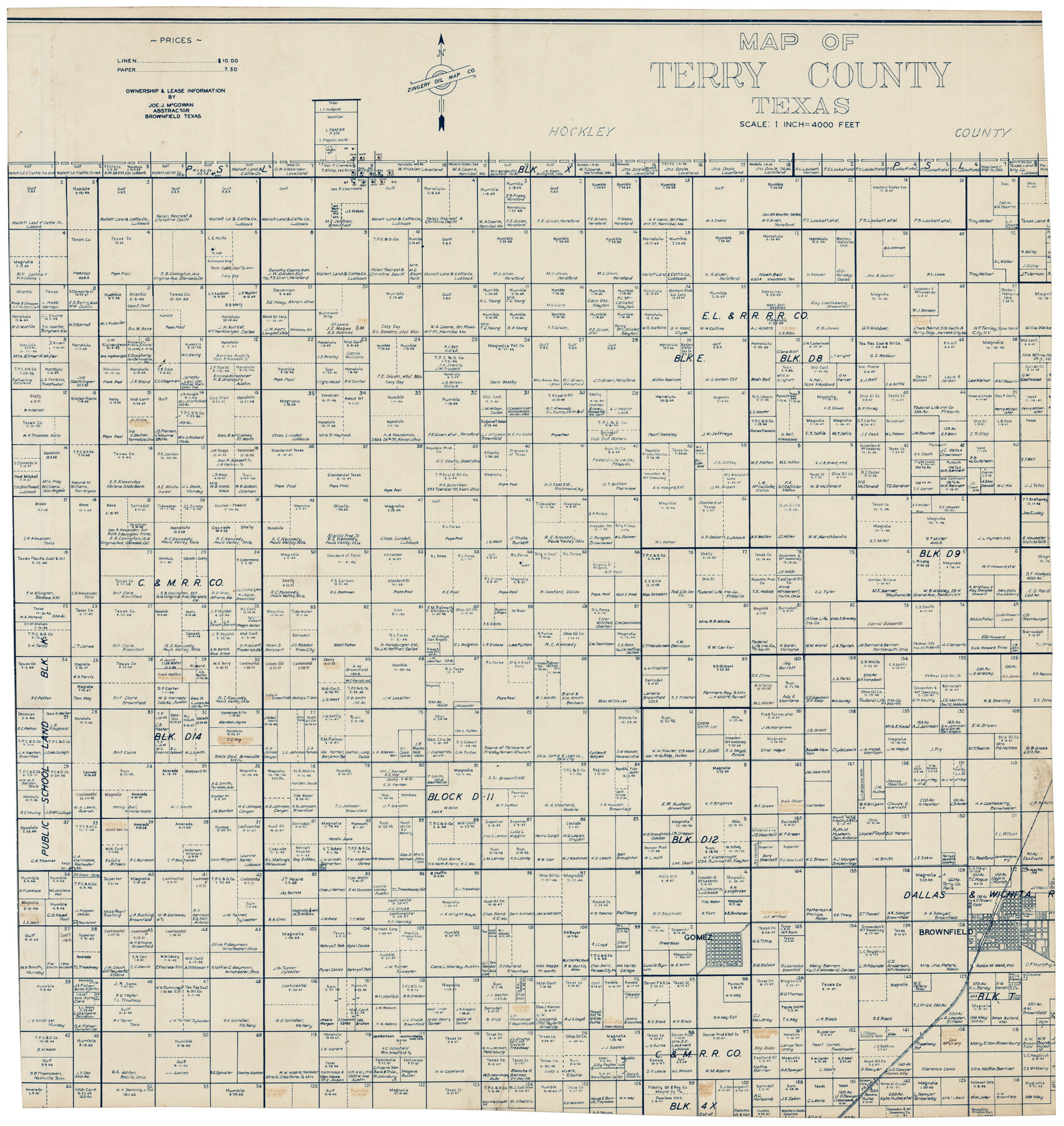
Map of Terry County
-
Map/Doc
92908
-
Collection
Twichell Survey Records
-
People and Organizations
Zingery Oil Map Co. (Compiler)
-
Counties
Terry
-
Subjects
County
-
Height x Width
26.5 x 27.8 inches
67.3 x 70.6 cm
Part of: Twichell Survey Records
[Northwest part of the County]
![90841, [Northwest part of the County], Twichell Survey Records](https://historictexasmaps.com/wmedia_w700/maps/90841-2.tif.jpg)
Print $20.00
- Digital $50.00
[Northwest part of the County]
Size 17.9 x 34.9 inches
Map/Doc 90841
Sketch in Southeastern Portion of Stephens County

Print $20.00
- Digital $50.00
Sketch in Southeastern Portion of Stephens County
1919
Size 29.0 x 21.7 inches
Map/Doc 91841
[Blocks A-10, A-11, and A-12]
![92669, [Blocks A-10, A-11, and A-12], Twichell Survey Records](https://historictexasmaps.com/wmedia_w700/maps/92669-1.tif.jpg)
Print $20.00
- Digital $50.00
[Blocks A-10, A-11, and A-12]
Size 19.7 x 20.0 inches
Map/Doc 92669
[Sketch showing H. T. & B. section 126 and B. H. Epperson]
![90932, [Sketch showing H. T. & B. section 126 and B. H. Epperson], Twichell Survey Records](https://historictexasmaps.com/wmedia_w700/maps/90932-1.tif.jpg)
Print $20.00
- Digital $50.00
[Sketch showing H. T. & B. section 126 and B. H. Epperson]
Size 23.9 x 32.5 inches
Map/Doc 90932
[Sketch showing I. G. Yates SF 12341 and surrounding surveys]
![93106, [Sketch showing I. G. Yates SF 12341 and surrounding surveys], Twichell Survey Records](https://historictexasmaps.com/wmedia_w700/maps/93106-1.tif.jpg)
Print $20.00
- Digital $50.00
[Sketch showing I. G. Yates SF 12341 and surrounding surveys]
Size 25.9 x 21.6 inches
Map/Doc 93106
[Leagues 11 and 22]
![91111, [Leagues 11 and 22], Twichell Survey Records](https://historictexasmaps.com/wmedia_w700/maps/91111-1.tif.jpg)
Print $20.00
- Digital $50.00
[Leagues 11 and 22]
1925
Size 14.0 x 13.6 inches
Map/Doc 91111
[Sketch showing various County School Land Leagues]
![89736, [Sketch showing various County School Land Leagues], Twichell Survey Records](https://historictexasmaps.com/wmedia_w700/maps/89736-1.tif.jpg)
Print $40.00
- Digital $50.00
[Sketch showing various County School Land Leagues]
Size 60.6 x 38.5 inches
Map/Doc 89736
[Sketch showing E. line of Lipscomb County along Oklahoma border]
![89718, [Sketch showing E. line of Lipscomb County along Oklahoma border], Twichell Survey Records](https://historictexasmaps.com/wmedia_w700/maps/89718-1.tif.jpg)
Print $40.00
- Digital $50.00
[Sketch showing E. line of Lipscomb County along Oklahoma border]
Size 68.7 x 9.6 inches
Map/Doc 89718
Tascotal Mesa Quadrangle

Print $20.00
- Digital $50.00
Tascotal Mesa Quadrangle
1917
Size 17.0 x 20.7 inches
Map/Doc 90134
J. N. Watson Subdivision of Blocks 1, 6, 7, and 43, Lamesa, Texas

Print $20.00
- Digital $50.00
J. N. Watson Subdivision of Blocks 1, 6, 7, and 43, Lamesa, Texas
Size 11.6 x 24.8 inches
Map/Doc 92574
Plat in Pecos County, Texas

Print $20.00
- Digital $50.00
Plat in Pecos County, Texas
Size 39.1 x 36.2 inches
Map/Doc 89830
Sundown Located on Tracts Number 58 and 59 Bob Slaughter Block Hockley County, Texas

Print $20.00
- Digital $50.00
Sundown Located on Tracts Number 58 and 59 Bob Slaughter Block Hockley County, Texas
1928
Size 21.4 x 19.4 inches
Map/Doc 92233
You may also like
Leon County Rolled Sketch 34

Print $20.00
- Digital $50.00
Leon County Rolled Sketch 34
1999
Size 31.8 x 37.1 inches
Map/Doc 87502
Liberty County Sketch File 33a

Print $4.00
- Digital $50.00
Liberty County Sketch File 33a
1874
Size 7.9 x 8.2 inches
Map/Doc 29969
Parker County Sketch File 38

Print $20.00
- Digital $50.00
Parker County Sketch File 38
Size 21.7 x 13.3 inches
Map/Doc 12149
Part of west line of Dawson County rough sketch from surveyor's blueprint

Print $20.00
- Digital $50.00
Part of west line of Dawson County rough sketch from surveyor's blueprint
1915
Size 14.0 x 20.2 inches
Map/Doc 90628
Intracoastal Waterway - Gibbstown to Port Arthur

Print $20.00
- Digital $50.00
Intracoastal Waterway - Gibbstown to Port Arthur
1961
Size 26.6 x 38.7 inches
Map/Doc 69833
Real County Working Sketch 83

Print $20.00
- Digital $50.00
Real County Working Sketch 83
1986
Size 25.7 x 43.0 inches
Map/Doc 71975
Panola County Sketch File 19

Print $14.00
- Digital $50.00
Panola County Sketch File 19
Size 11.7 x 7.7 inches
Map/Doc 33478
Culberson County Working Sketch Graphic Index, Sheet A (Sketches 1 to 40)

Print $40.00
- Digital $50.00
Culberson County Working Sketch Graphic Index, Sheet A (Sketches 1 to 40)
1943
Size 51.6 x 32.7 inches
Map/Doc 76514
Jack County Working Sketch 18

Print $20.00
- Digital $50.00
Jack County Working Sketch 18
1986
Size 29.8 x 35.5 inches
Map/Doc 66444
Terry County Sketch File 17

Print $5.00
- Digital $50.00
Terry County Sketch File 17
1956
Size 27.7 x 24.7 inches
Map/Doc 12429
Dallas County Boundary File 6b

Print $40.00
- Digital $50.00
Dallas County Boundary File 6b
Size 14.1 x 8.6 inches
Map/Doc 52207
Map of The Surveyed Part of Peters Colony Texas

Print $40.00
- Digital $50.00
Map of The Surveyed Part of Peters Colony Texas
1858
Size 45.6 x 58.5 inches
Map/Doc 1982